Fryeburg - Eastern Slopes Regional
Airport details
| Country | United States of America |
| State | Maine |
| Region | K6 |
| Airspace | Boston Ctr |
| Municipality | Fryeburg |
| Elevation | 454ft (138m) |
| Timezone | GMT -5 |
| Coordinates | 43.99114, -70.94789 |
| Magnetic var | |
| Type | land |
| Available since | X-Plane v10.40 |
| ICAO code | KIZG |
| IATA code | FRY |
| FAA code | IZG |
Communication
| Eastern Slopes Regional ASOS | 135.775 |
| Eastern Slopes Regional CTAF/UNICOM | 122.800 |
| Eastern Slopes Regional PORTLAND Approach/Departure | 125.500 |
Nearby Points of Interest:
Fryeburg Public Library
-Marion Parsons House
-Fryeburg Registry of Deeds
-Barrows-Steadman Homestead
-Squire Chase House
-Rivercroft Farm
-Former Fryeburg Town House
-Conway Public Library
-Majestic Theatre
-William K. Eastman House
-John Watson House
-Lovell Village Church
-North Conway 5 and 10 Cent Store
-Soldiers Memorial Library
-Hubbard-Cotton Store
-Abenaki Indian Shop and Camp
-White Meetinghouse
-Peabody-Fitch House
-Moses Hutchins House
-Porter Old Meetinghouse
-Lt. Robert Andrews House
-Benjamin Cleaves House
-William F. Perry House
-Dalton Holmes Davis Memorial Library
-John and Maria Webb House
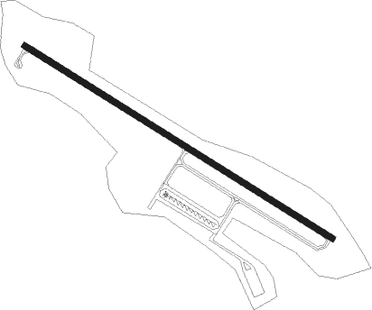
Runway info
| Runway 14 / 32 | ||
| length | 1278m (4193ft) | |
| bearing | 118° / 298° | |
| width | 23m (75ft) | |
| surface | asphalt | |
Nearby beacons
| code | identifier | dist | bearing | frequency |
|---|---|---|---|---|
| LE | LEWIE (AUBURN-LEWISTON) NDB | 26.4 | 93° | 240 |
| ENE | KENNEBUNK VOR/DME | 36.9 | 149° | 117.10 |
| LC | BLNAP (LACONIA) NDB | 37.3 | 232° | 328 |
| GMA | MAHN (WHITEFIELD) NDB | 38.8 | 297° | 386 |
| SF | SANFD (SANFORD) NDB | 39.7 | 170° | 349 |
| BML | DME | 39.9 | 340° | 116.55 |
| ESG | ROLLINS (ROLLINSFORD) NDB | 46.5 | 171° | 260 |
| CON | CONCORD VOR/DME | 53.7 | 219° | 112.90 |
| PSM | (PORTSMOUTH) DME | 54.6 | 173° | 116.50 |
| CO | EPSOM (CONCORD) NDB | 56.8 | 210° | 216 |
| RQM | RANGELEY NDB | 57.2 | 12° | 221 |
Instrument approach procedures
| runway | airway (heading) | route (dist, bearing) |
|---|---|---|
| RW32 | SERPA (298°) | SERPA 3600ft |
| RNAV | SERPA 3600ft ANDRU (6mi, 298°) 3100ft HIRMN (3mi, 298°) 2200ft KIZG (6mi, 298°) 471ft (4589mi, 122°) 1040ft USNEC (4586mi, 302°) WESOV (7mi, 107°) SERPA (13mi, 175°) 3600ft SERPA (turn) |
Disclaimer
The information on this website is not for real aviation. Use this data with the X-Plane flight simulator only! Data taken with kind consent from X-Plane 12 source code and data files. Content is subject to change without notice.