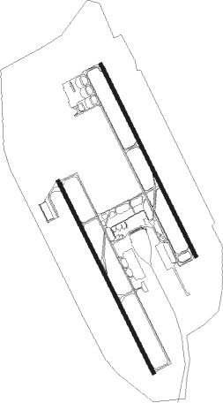
Jackson - Jackson Evers Intl
Airport details
| Country | United States of America |
| State | Mississippi |
| Region | K7 |
| Airspace | Memphis Ctr |
| Municipality | Jackson |
| Elevation | 346ft (105m) |
| Timezone | GMT -6 |
| Coordinates | 32.31116, -90.07589 |
| Magnetic var | |
| Type | land |
| Available since | X-Plane v10.40 |
| ICAO code | KJAN |
| IATA code | JAN |
| FAA code | JAN |
Communication
| Jackson Evers Intl ATIS | 121.050 |
| Jackson Evers Intl CTAF | 120.900 |
| Jackson Evers Intl UNICOM | 122.950 |
| Jackson Evers Intl Ground Control | 121.700 |
| Jackson Evers Intl Tower | 120.900 |
| Jackson Evers Intl Approach/Departure | 123.900 |
Approach frequencies
| ILS-cat-III | RW16L | 110.5 | 18.00mi |
| ILS-cat-I | RW34L | 109.3 | 18.00mi |
| 3° GS | RW34L | 109.3 | 18.00mi |
| 3° GS | RW16L | 110.5 | 18.00mi |
Nearby Points of Interest:
Pearl Street Historic District
-Fountainhead
-Castle Crest
-Downtown Brandon Historic District
-Stevens-Buchanan House
-Warren-Guild-Simmons House
-Millsaps-Buie House
-Virden-Patton House
-Garner Wynn Green House
-Sims House
-Joseph Henry Morris House
-Old Mississippi State Capitol
-Manship House
-Woodrow Wilson Bridge
-Mississippi State Capitol
-Spengler–Thomas Building
-Central Fire Station
-Jackson City Hall
-Mississippi Governor's Mansion
-Smith Park Architectural District
-Farish Street Neighborhood Historic District
-Ervin Lewis House
-The Cedars
-Sub Rosa
-Wolfe House

Nearby beacons
| code | identifier | dist | bearing | frequency |
|---|---|---|---|---|
| JA | ALLEN (JACKSON) NDB | 6.4 | 337° | 365 |
| MHZ | MAGNOLIA (MADISON) VORTAC | 7.4 | 349° | 113.20 |
| JH | BRENZ (JACKSON) NDB | 11.2 | 299° | 260 |
| TKH | TALLULAH (VICKSBURG/TALLULAH) NDB | 48.3 | 266° | 344 |
| LBY | EATON (HATTIESBURG) VORTAC | 65.5 | 140° | 110.60 |
Instrument approach procedures
| runway | airway (heading) | route (dist, bearing) |
|---|---|---|
| RW16L | KAYER (156°) | KAYER 3000ft |
| RNAV | KAYER 3000ft HARAG (7mi, 154°) 2200ft HIGPU (3mi, 154°) 1340ft KJAN (4mi, 159°) 360ft (5409mi, 110°) 512ft MASPY (5404mi, 290°) 3000ft MASPY (turn) | |
| RW16R | MOPKE (153°) | MOPKE 3000ft |
| RNAV | MOPKE 3000ft DEKLE (7mi, 154°) 2000ft WIRSI (2mi, 155°) 1280ft KJAN (3mi, 149°) 360ft (5409mi, 110°) 621ft FAVIN (5405mi, 290°) 3000ft FAVIN (turn) | |
| RW34L | FAVIN (336°) | FAVIN 3000ft |
| RNAV | FAVIN 3000ft DABEY (7mi, 335°) 1800ft CEKBI (2mi, 335°) 1020ft KJAN (3mi, 341°) 387ft (5409mi, 110°) 579ft MOPKE (5414mi, 290°) 3000ft MOPKE (turn) | |
| RW34R | MASPY (333°) | MASPY 3000ft |
| RNAV | MASPY 3000ft ZUTSI (7mi, 335°) 2300ft KJAN (6mi, 332°) 401ft (5409mi, 110°) 646ft KAYER (5414mi, 290°) 3000ft KAYER (turn) |
Disclaimer
The information on this website is not for real aviation. Use this data with the X-Plane flight simulator only! Data taken with kind consent from X-Plane 12 source code and data files. Content is subject to change without notice.