Springerville - Springerville Muni
Airport details
| Country | United States of America |
| State | Arizona |
| Region | K2 |
| Airspace | Albuquerque Ctr |
| Municipality | Springerville |
| Elevation | 7049ft (2149m) |
| Timezone | GMT -7 |
| Coordinates | 34.13166, -109.30674 |
| Magnetic var | |
| Type | land |
| Available since | X-Plane v10.40 |
| ICAO code | KJTC |
| IATA code | n/a |
| FAA code | n/a |
Communication
| Springerville Muni AWOS-3PT | 119.650 |
| Springerville Muni CTAF/UNICOM | 122.800 |
Nearby Points of Interest:
Casa Malpaís
-Eagar Townsite Historic District
-Colter Ranch Historic District
-Alpine Elementary School
-Isaacson Building
-Lake Mountain Lookout Complex
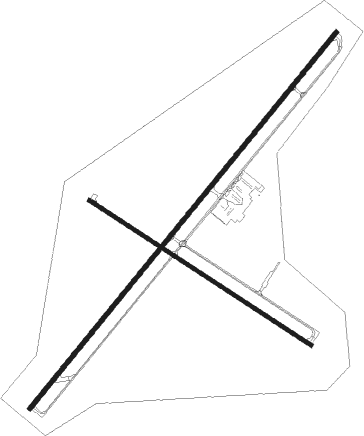
Runway info
Runway 3 / 21  | ||
| length | 2567m (8422ft) | |
| bearing | 49° / 229° | |
| width | 23m (75ft) | |
| surface | asphalt | |
| Runway 11 / 29 | ||
| length | 1402m (4600ft) | |
| bearing | 123° / 303° | |
| width | 18m (60ft) | |
| surface | asphalt | |
Nearby beacons
| code | identifier | dist | bearing | frequency |
|---|---|---|---|---|
| SJN | ST JOHNS VORTAC | 19.3 | 29° | 112.30 |
| ZUN | ZUNI VORTAC | 50.6 | 10° | 113.40 |
Instrument approach procedures
| runway | airway (heading) | route (dist, bearing) |
|---|---|---|
| RW21 | IFADE (215°) | IFADE 9500ft |
| RW21 | SJN (209°) | SJN IFADE (9mi, 203°) 9500ft |
| RNAV | IFADE 9500ft IWEDU (5mi, 214°) 8700ft CHAPN (2mi, 214°) 7900ft MIKVE (2mi, 214°) 7216ft (6358mi, 107°) 7455ft IFADE (6352mi, 287°) 12000ft IFADE (turn) |
Disclaimer
The information on this website is not for real aviation. Use this data with the X-Plane flight simulator only! Data taken with kind consent from X-Plane 12 source code and data files. Content is subject to change without notice.