Janesville - Southern Wisconsin Regl
Airport details
| Country | United States of America |
| State | Wisconsin |
| Region | K5 |
| Airspace | Chicago Ctr |
| Municipality | Janesville |
| Elevation | 808ft (246m) |
| Timezone | GMT -6 |
| Coordinates | 42.61414, -89.03838 |
| Magnetic var | |
| Type | land |
| Available since | X-Plane v10.40 |
| ICAO code | KJVL |
| IATA code | JVL |
| FAA code | JVL |
Communication
| Southern Wisconsin Regl ATIS | 128.250 |
| Southern Wisconsin Regl UNICOM | 122.950 |
| Southern Wisconsin Regl CTAF | 118.800 |
| Southern Wisconsin Regl JANESVILLE Ground Control/CLE Delivery | 121.650 |
| Southern Wisconsin Regl JANESVILLE Tower | 118.800 |
| Southern Wisconsin Regl ROCKFORD Approach/Departure | 121.000 |
Approach frequencies
| ILS-cat-I | RW04 | 109.1 | 18.00mi |
| ILS-cat-I | RW32 | 111.35 | 18.00mi |
| 3° GS | RW04 | 109.1 | 18.00mi |
| 3° GS | RW32 | 111.35 | 18.00mi |
Nearby Points of Interest:
John H. Jones House
-Court Street Methodist Church
-Jefferson Avenue Historic District
-James B. Crosby House
-Shopiere Congregational Church
-Beloit Water Tower
-City of Beloit Waterworks and Pump Station
-Dougan Round Barn
-First Congregational Church
-Lathrop-Munn Cobblestone House
-Erastus Dean Farmstead
-John Smith House
-Richardson-Brinkman Cobblestone House
-H.D. Jameson House
-Orfordville Depot
-Macktown Historic District
-Samuel S. Jones Cobblestone House
-Milton College
-Abram Allen House
-Risum Round Barn
-Chicago & North Western Railway Stone Arch Bridge
-West Luther Valley Lutheran Church
-Edgerton Depot
-Robert Weber Round Barn
-Francis West Smith House
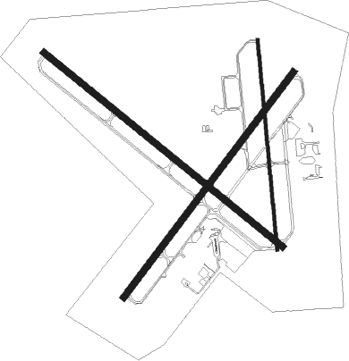
Runway info
Runway 14 / 32  | ||
| length | 2224m (7297ft) | |
| bearing | 125° / 305° | |
| width | 46m (150ft) | |
| surface | concrete | |
| Runway 4 / 22 | ||
| length | 2041m (6696ft) | |
| bearing | 50° / 230° | |
| width | 46m (150ft) | |
| surface | asphalt | |
| Runway 18 / 36 | ||
| length | 1527m (5010ft) | |
| bearing | 179° / 359° | |
| width | 23m (75ft) | |
| surface | asphalt | |
Nearby beacons
| code | identifier | dist | bearing | frequency |
|---|---|---|---|---|
| JVL | JANESVILLE VOR/DME | 4.4 | 230° | 114.30 |
| RFD | DME | 24.4 | 202° | 110.80 |
| BUU | (BURLINGTON) DME | 32.8 | 84° | 114.50 |
| MSN | MADISON VORTAC | 34.5 | 330° | 108.60 |
| RYV | ROCK RIVER (WATERTOWN) NDB | 36.3 | 29° | 371 |
| PLL | POLO VOR/DME | 44.5 | 217° | 111.20 |
| BAE | BADGER (MILWAUKEE) VOR/DME | 44.8 | 56° | 116.40 |
| UNU | JUNEAU NDB | 51.1 | 22° | 344 |
| DPA | DUPAGE (CHICAGO) VOR/DME | 53.1 | 136° | 108.40 |
| BJB | WEST BEND VOR | 62.9 | 49° | 109.80 |
| DLL | DELLS (BARABOO) VORTAC | 64.6 | 322° | 117 |
Instrument approach procedures
| runway | airway (heading) | route (dist, bearing) |
|---|---|---|
| RW04 | CULMO (51°) | CULMO 3100ft |
| RW04 | DAVIS (63°) | DAVIS CULMO (7mi, 81°) 3100ft |
| RW04 | LOCEN (317°) | LOCEN KATYE (11mi, 244°) 3100ft CULMO (5mi, 303°) 3100ft |
| RW04 | TAVNE (121°) | TAVNE HESAN (12mi, 223°) 3100ft CULMO (5mi, 123°) 3100ft |
| RNAV | CULMO 3100ft TAVOC (6mi, 50°) 2700ft FIRDU (4mi, 50°) 1480ft KJVL (2mi, 57°) 854ft OTLEE (12mi, 49°) 3100ft OTLEE (turn) | |
| RW14 | DAVIS (63°) | DAVIS WITAL (16mi, 14°) 3100ft TAYOR (5mi, 52°) 3100ft |
| RW14 | RASTT (237°) | RASTT WOROX (22mi, 266°) 3100ft TAYOR (5mi, 232°) 3100ft |
| RW14 | TAYOR (125°) | TAYOR 3100ft |
| RNAV | TAYOR 3100ft JESKO (6mi, 125°) 2600ft VOGMY (3mi, 125°) 1740ft KJVL (4mi, 126°) 855ft (5363mi, 116°) 1003ft TIRRO (5354mi, 296°) 3100ft TIRRO (turn) | |
| RW22 | LOCEN (317°) | LOCEN DACEK (14mi, 38°) 3100ft OTLEE (5mi, 303°) 3100ft WUTSI (4mi, 230°) 2700ft |
| RW22 | OTLEE (229°) | OTLEE 3100ft WUTSI (4mi, 230°) 2700ft |
| RW22 | RASTT (237°) | RASTT OTLEE (10mi, 245°) 3100ft WUTSI (4mi, 230°) 2700ft |
| RW22 | TAVNE (121°) | TAVNE FORVO (12mi, 57°) 3100ft OTLEE (5mi, 123°) 3100ft WUTSI (4mi, 230°) 2700ft |
| RNAV | WUTSI 2700ft TEGGU (2mi, 230°) 2500ft KJVL (6mi, 227°) 865ft CULMO (12mi, 231°) 3100ft CULMO (turn) | |
| RW32 | DAVIS (63°) | DAVIS WASOR (21mi, 93°) 3100ft TIRRO (5mi, 52°) 3100ft |
| RW32 | RASTT (237°) | RASTT WEPAX (20mi, 197°) 3100ft TIRRO (5mi, 232°) 3100ft |
| RW32 | TIRRO (305°) | TIRRO 3100ft |
| RNAV | TIRRO 3100ft JODER (6mi, 305°) 2600ft KJVL (5mi, 304°) 857ft (5363mi, 116°) 1200ft TAYOR (5372mi, 296°) 3100ft TAYOR (turn) |
Disclaimer
The information on this website is not for real aviation. Use this data with the X-Plane flight simulator only! Data taken with kind consent from X-Plane 12 source code and data files. Content is subject to change without notice.