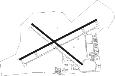
Jackson - Jackson Co Reynolds Fld
Airport details
| Country | United States of America |
| State | Michigan |
| Region | K5 |
| Airspace | Cleveland Ctr |
| Municipality | Blackman Charter Township |
| Elevation | 1000ft (305m) |
| Timezone | GMT -5 |
| Coordinates | 42.26042, -84.46044 |
| Magnetic var | |
| Type | land |
| Available since | X-Plane v10.40 |
| ICAO code | KJXN |
| IATA code | JXN |
| FAA code | JXN |
Communication
| Jackson Co Reynolds Fld ATIS | 125.725 |
| Jackson Co Reynolds Fld ATIS | 127.950 |
| Jackson Co Reynolds Fld CTAF | 128.475 |
| Jackson Co Reynolds Fld UNICOM | 122.950 |
| Jackson Co Reynolds Fld Ground Control/Clearance DEL | 121.900 |
| Jackson Co Reynolds Fld Tower | 128.475 |
| Jackson Co Reynolds Fld Great Lakes Approach | 127.300 |
| Jackson Co Reynolds Fld Great Lakes Departure | 127.300 |
Approach frequencies
| ILS-cat-I | RW25 | 109.1 | 18.00mi |
| 3° GS | RW25 | 109.1 | 18.00mi |
Nearby Points of Interest:
Michigan State Prison
-Peoples National Bank Building
-Andrew Wilcox House
-M-50–Sandstone Creek Bridge
-Paddock-Hubbard House
-Mann House (Concord, Michigan)
-Concord Village Historic District
-Gordon Hitt Farmstead
-Superior Street Commercial Historic District
-Mill Street–South Branch Raisin River Bridge
-Ford Motor Company Brooklyn Plant
-Walker Tavern
-Saint Michael and All Angels' Episcopal Church and Cambridge Township Cemetery
-Stockbridge Town Hall
-Homer Village Historic District
-Isaac N. Reynolds House
-Saint Joseph Church and Shrine
-Irish Hills Towers
-Grace Episcopal Church
-J.J. Deal and Son Carriage Factory
-Merrylees-Post House
-John Raynor House
-Ingham County Courthouse
-Ash Street-Sycamore Creek Bridge
-Michigan Central Railroad Mason Depot
Nearby beacons
| code | identifier | dist | bearing | frequency |
|---|---|---|---|---|
| JXN | DME | 0.1 | 122° | 115.45 |
| LFD | LITCHFIELD VOR/DME | 18 | 237° | 111.20 |
| TCU | TECUMSEH NDB | 28.9 | 112° | 239 |
| ADG | ADRIAN NDB | 29 | 136° | 278 |
| BT | BATOL (BATTLE CREEK) NDB | 32.7 | 278° | 272 |
| SVM | SALEM VORTAC | 39.4 | 80° | 114.30 |
| PSI | DME | 48.8 | 65° | 111 |
| TO | TOPHR (TOLEDO) NDB | 48.8 | 143° | 219 |
| TOL | TOLEDO TACAN | 49.7 | 135° | 112.50 |
| IRS | STURGIS NDB | 51 | 245° | 382 |
| FNT | FLINT VORTAC | 52.8 | 45° | 116.90 |
| GR | KNOBS (GRAND RAPIDS) NDB | 55.7 | 305° | 263 |
| GW | SHENK (AUBURN) NDB | 61.1 | 207° | 227 |
Instrument approach procedures
| runway | airway (heading) | route (dist, bearing) |
|---|---|---|
| RW07 | DOSGE (45°) | DOSGE LNDEN (7mi, 330°) 2700ft |
| RW07 | LNDEN (73°) | LNDEN 2700ft |
| RW07 | PYRON (96°) | PYRON LNDEN (7mi, 150°) 2700ft |
| RNAV | LNDEN 2700ft BERWI (6mi, 73°) 2700ft KONGZ (3mi, 73°) 1600ft KJXN (2mi, 74°) 1022ft (5159mi, 117°) 1258ft IGLAW (5149mi, 297°) 3000ft IGLAW (turn) | |
| RW14 | RIGSE (125°) | RIGSE 3000ft |
| RNAV | RIGSE 3000ft ORECO (7mi, 125°) 2700ft ZAVED (4mi, 125°) 1540ft KJXN (2mi, 123°) 1017ft (5159mi, 117°) 1345ft JERIK (5150mi, 297°) 3100ft JERIK (turn) | |
| RW25 | FEROM (224°) | FEROM IGLAW (7mi, 151°) 3100ft |
| RW25 | IGLAW (253°) | IGLAW 3100ft |
| RW25 | JAYCC (276°) | JAYCC IGLAW (7mi, 331°) 3100ft |
| RNAV | IGLAW 3100ft DUBWY (6mi, 253°) 2700ft HERMY (3mi, 253°) 1900ft KJXN (3mi, 252°) 1039ft (5159mi, 117°) 1195ft LNDEN (5170mi, 296°) 2700ft LNDEN (turn) | |
| RW32 | CIPOR (330°) | CIPOR JERIK (5mi, 52°) 3100ft |
| RW32 | JERIK (305°) | JERIK 3100ft |
| RW32 | WYLLD (285°) | WYLLD JERIK (5mi, 232°) 3100ft |
| RNAV | JERIK 3100ft KUSRE (6mi, 305°) 2700ft KJXN (5mi, 306°) 1046ft (5159mi, 117°) 1401ft RIGSE (5169mi, 297°) 3000ft RIGSE (turn) |
Disclaimer
The information on this website is not for real aviation. Use this data with the X-Plane flight simulator only! Data taken with kind consent from X-Plane 12 source code and data files. Content is subject to change without notice.

