Sylvania - Plantation Arpk
Airport details
| Country | United States of America |
| State | Georgia |
| Region | K7 |
| Airspace | Jacksonville Ctr |
| Municipality | Screven County |
| Elevation | 187ft (57m) |
| Timezone | GMT -5 |
| Coordinates | 32.64528, -81.59711 |
| Magnetic var | |
| Type | land |
| Available since | X-Plane v10.40 |
| ICAO code | KJYL |
| IATA code | JYL |
| FAA code | JYL |
Communication
| Plantation Arpk AWOS 3 | 118.875 |
| Plantation Arpk CTAF/UNICOM | 122.800 |
Nearby Points of Interest:
Harris-Murrow-Trowell House
-Seaborn Goodall House
-Donehoo-Brannen House
-Savannah Avenue Historic District
-Bulloch County Courthouse
-Dr. Madison Monroe Holland House
-James Alonzo Brannen House
-Georgia Welcome Center
-The Pineland
-John Lawton House
-Downtown Millen Historic District
-Jenkins County Courthouse
-J.C. Richardson House
-Erwin House (Allendale, South Carolina)
-McCanaan Missionary Baptist Church and Cemetery
-Upper Lott's Creek Primitive Baptist Church and Cemetery
-Old Effingham County Courthouse
-Gravel Hill Plantation (Allendale, South Carolina)
-Camp Lawton
-Roselawn (Allendale, South Carolina)
-Sapp Plantation
-Oak Grove
-Hampton County Courthouse
-Virginia Durant Young House
-Colding-Walker House
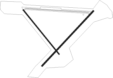
Runway info
Runway 5 / 23  | ||
| length | 1525m (5003ft) | |
| bearing | 52° / 232° | |
| width | 30m (100ft) | |
| surface | asphalt | |
| Runway 15 / 33 | ||
| length | 1156m (3793ft) | |
| bearing | 141° / 321° | |
| width | 23m (75ft) | |
| surface | asphalt | |
| blast zone | 94m (308ft) / 255m (837ft) | |
Nearby beacons
| code | identifier | dist | bearing | frequency |
|---|---|---|---|---|
| JYL | SYLVANIA NDB | 0.2 | 36° | 245 |
| BZ | BULLO (STATESBORO) NDB | 14.2 | 196° | 407 |
| ALD | ALLENDALE VOR | 26.8 | 40° | 116.70 |
| SAV | SAVANNAH VORTAC | 36.1 | 141° | 115.95 |
| AG | BUSHE (AUGUSTA) NDB | 42.3 | 331° | 233 |
| EEX | EMANUEL COUNTY (SWAINSBORO) NDB | 43.2 | 271° | 309 |
| UQN | ONYUN (VIDALIA) NDB | 43.6 | 239° | 372 |
| SVN | HUNTER (SAVANNAH) VOR/DME | 44.5 | 144° | 111.60 |
| NBC | BEAUFORT TACAN | 45.6 | 101° | 110.50 |
| MOQ | MC INTOSH (HINESVILLE) NDB | 49 | 174° | 263 |
| SV | WASSA (SAVANNAH) NDB | 49.4 | 136° | 335 |
| EMR | EMORY (AUGUSTA) NDB | 53 | 334° | 385 |
| BHC | BAXLEY NDB | 69 | 220° | 376 |
Instrument approach procedures
| runway | airway (heading) | route (dist, bearing) |
|---|---|---|
| RW05 | TIKIE (52°) | TIKIE 2500ft |
| RNAV | TIKIE 2500ft LIPSE (7mi, 52°) 1900ft CESOR (2mi, 52°) 1200ft KJYL (3mi, 50°) 210ft (4981mi, 112°) 428ft HOBOB (4972mi, 292°) 2000ft HOBOB (turn) | |
| RW23 | HOBOB (233°) | HOBOB 2000ft |
| RNAV | HOBOB 2000ft BUYDA (7mi, 232°) 1900ft THOLN (3mi, 232°) 800ft KJYL (3mi, 234°) 228ft (4981mi, 112°) 494ft TIKIE (4989mi, 292°) 2500ft TIKIE (turn) |
Disclaimer
The information on this website is not for real aviation. Use this data with the X-Plane flight simulator only! Data taken with kind consent from X-Plane 12 source code and data files. Content is subject to change without notice.