Lafayette - Purdue University
Airport details
| Country | United States of America |
| State | Indiana |
| Region | K5 |
| Airspace | Chicago Ctr |
| Municipality | West Lafayette |
| Elevation | 604ft (184m) |
| Timezone | GMT -5 |
| Coordinates | 40.41230, -86.93689 |
| Magnetic var | |
| Type | land |
| Available since | X-Plane v10.40 |
| ICAO code | KLAF |
| IATA code | LAF |
| FAA code | LAF |
Communication
| Purdue University Lafayette ATIS | 127.750 |
| Purdue University Lafayette CTAF | 119.600 |
| Purdue University Lafayette Ground | 121.900 |
| Purdue University Lafayette Tower | 119.600 |
| Purdue University Grissom Approach | 123.850 |
Approach frequencies
| ILS-cat-I | RW10 | 110.3 | 18.00mi |
| 3° GS | RW10 | 110.3 | 18.00mi |
Nearby Points of Interest:
Indian Trail Road–Belle River Bridge
-Former Alpha Tau Omega Fraternity House
-Jesse Andrew House
-The Varsity
-Morton School
-Samara
-Tippecanoe County Courthouse
-Downtown Lafayette Historic District
-Falley Home
-Marian Apartments
-Centennial Neighborhood District
-Temple Israel
-Judge Cyrus Ball House
-Upper Main Street Historic District
-Ninth Street Hill Neighborhood Historic District
-Moses Fowler House
-William Potter House
-James H. Ward House
-Jefferson Historic District
-Curtis-Grace House
-St. Mary Historic District
-Scott Street Pavilion
-Waldron-Beck House and Carriage House
-Indiana State Soldiers Home Historic District
-James Pierce Jr. House
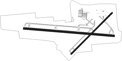
Runway info
Runway 10 / 28  | ||
| length | 2007m (6585ft) | |
| bearing | 97° / 277° | |
| width | 46m (150ft) | |
| surface | asphalt | |
| blast zone | 61m (200ft) / 44m (144ft) | |
| Runway 5 / 23 | ||
| length | 1289m (4229ft) | |
| bearing | 57° / 237° | |
| width | 30m (100ft) | |
| surface | asphalt | |
| displ threshold | 0m (0ft) / 99m (325ft) | |
Nearby beacons
| code | identifier | dist | bearing | frequency |
|---|---|---|---|---|
| LA | EARLE (LAFAYETTE) NDB | 5.3 | 277° | 401 |
| BVT | BOILER (LAFAYETTE) VORTAC | 10.5 | 317° | 115.10 |
| CFJ | CRAWFORDSVILLE NDB | 25.9 | 177° | 388 |
| DN | JULIP (DANVILLE) NDB | 28.1 | 258° | 332 |
| DNV | DANVILLE VORTAC | 29.2 | 259° | 111 |
| GUS | GRISSOM (PERU) VORTAC | 38.4 | 73° | 108.45 |
| OKK | KOKOMO VORTAC | 40.7 | 83° | 113.50 |
| VHP | BRICKYARD VORTAC | 44.4 | 136° | 116.30 |
| UMP | METROPOLITAN (INDIANAPOLIS) NDB | 49.6 | 118° | 338 |
| FV | LAREZ (INDIANAPOLIS) NDB | 50.7 | 130° | 349 |
| OXI | KNOX VOR/DME | 56.1 | 18° | 115.60 |
| CO | COLFA (INDIANAPOLIS) NDB | 57 | 135° | 232 |
| IK | LUKOW (KANKAKEE) NDB | 57 | 302° | 272 |
| TTH | TERRE HAUTE VORTAC | 57.2 | 199° | 115.30 |
| IKK | DME | 57.5 | 306° | 111.60 |
| EON | PEOTONE VORTAC | 64.4 | 315° | 113.20 |
Instrument approach procedures
| runway | airway (heading) | route (dist, bearing) |
|---|---|---|
| RW10 | EXSAT (116°) | EXSAT 2600ft RESAW (5mi, 192°) 2600ft |
| RW10 | MALLA (79°) | MALLA 2600ft RESAW (5mi, 12°) 2600ft |
| RW10 | RESAW (97°) | RESAW 2600ft |
| RNAV | RESAW 2600ft ONAMY (6mi, 97°) 2300ft KLAF (6mi, 97°) 653ft OGREY (12mi, 97°) 2600ft OGREY (turn) | |
| RW28 | JEPFE (296°) | JEPFE 2600ft OGREY (5mi, 12°) 2600ft |
| RW28 | OBOPY (259°) | OBOPY 2600ft OGREY (5mi, 192°) 2600ft |
| RW28 | OGREY (277°) | OGREY 2600ft |
| RNAV | OGREY 2600ft ILRAY (6mi, 277°) 2300ft KUKDE (3mi, 277°) 1460ft KLAF (3mi, 277°) 644ft RESAW (12mi, 277°) 2600ft RESAW (turn) |
Disclaimer
The information on this website is not for real aviation. Use this data with the X-Plane flight simulator only! Data taken with kind consent from X-Plane 12 source code and data files. Content is subject to change without notice.