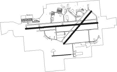
Lakeland - Lakeland Linder Intl
Airport details
| Country | United States of America |
| State | Florida |
| Region | K7 |
| Airspace | Miami Oceanic Ctr |
| Municipality | Lakeland |
| Elevation | 141ft (43m) |
| Timezone | GMT -5 |
| Coordinates | 27.98892, -82.01855 |
| Magnetic var | |
| Type | land |
| Available since | X-Plane v10.40 |
| ICAO code | KLAL |
| IATA code | LAL |
| FAA code | LAL |
Communication
| Lakeland Linder Intl Lakeland ATIS | 118.025 |
| Lakeland Linder Intl Lakeland UNICOM | 122.950 |
| Lakeland Linder Intl Lakeland Ground | 121.400 |
| Lakeland Linder Intl Lakeland Tower | 124.500 |
| Lakeland Linder Intl TAMPA Departure | 120.650 |
Approach frequencies
| ILS-cat-I | RW10 | 110.1 | 18.00mi |
| 3° GS | RW10 | 110.1 | 18.00mi |
Nearby Points of Interest:
Beacon Hill-Alta Vista Residential District
-Lake Hunter Terrace Historic District
-Dixieland Historic District
-South Lake Morton Historic District
-Child of the Sun
-Oates Building
-Polk Theatre
-East Lake Morton Residential District
-Old Lakeland High School
-Frances Langford Promenade
-Biltmore-Cumberland Historic District
-Bing Rooming House
-North Plant City Residential District
-Plant City High School
-Standard Oil Service Station
-Downtown Plant City Historic Residential District
-Old Polk County Courthouse
-Northeast Bartow Residential District
-South Bartow Residential District
-Benjamin Franklin Holland House
-John J. Swearingen House
-Lawrence Brown House
-Auburndale Citrus Growers Association Packing House
-Holland Jenks House
-Homeland School
Runway info
Nearby beacons
| code | identifier | dist | bearing | frequency |
|---|---|---|---|---|
| LAL | LAKELAND VORTAC | 0.2 | 120° | 116 |
| MCF | MACDILL (TAMPA) TACAN | 27.3 | 256° | 111 |
| TP | COSME (TAMPA) NDB | 27.4 | 281° | 368 |
| PIE | SAINT PETERSBURG VORTAC | 35.6 | 263° | 116.40 |
| PI | CAPOK(ST PETERSBURG-CLEARWATER NDB | 36.3 | 271° | 360 |
| OR | HERNY (ORLANDO) NDB | 43.8 | 48° | 221 |
| SRQ | SARASOTA VOR/DME | 45.4 | 223° | 117 |
| ORL | ORLANDO VORTAC | 49.1 | 51° | 112.20 |
Departure and arrival routes
| Transition altitude | 18000ft |
| Transition level | 18000ft |
| STAR starting points | distance | inbound heading | |
|---|---|---|---|
| ALL | |||
| RAYZZ2 | 61.1 | 86° | |
| LUBBR2 | 41.7 | 172° | |
| RW05 | |||
| MAATY2 | 58.1 | 114° | |
| RW10 | |||
| MAATY2 | 58.1 | 114° | |
| RW23 | |||
| MAATY2 | 58.1 | 114° | |
| RW28 | |||
| MAATY2 | 58.1 | 114° | |
Instrument approach procedures
| runway | airway (heading) | route (dist, bearing) |
|---|---|---|
| RW05 | IPUNE (71°) | IPUNE ZUXON (5mi, 131°) 2700ft |
| RW05 | SANOY (22°) | SANOY ZUXON (5mi, 311°) 2700ft |
| RW05 | ZUXON (47°) | ZUXON 2700ft |
| RNAV | ZUXON 2700ft BIYAT (6mi, 48°) 1700ft KLAL (5mi, 46°) 186ft (4982mi, 109°) 336ft OBTOQ (4979mi, 289°) PLUMY (12mi, 304°) 2000ft PLUMY (turn) | |
| RW10 | ARSHW (90°) | ARSHW 2700ft |
| RW10 | BOMRR (66°) | BOMRR ARSHW (6mi, 360°) 2700ft |
| RW10 | GUUNR (114°) | GUUNR ARSHW (6mi, 180°) 2700ft |
| RNAV | ARSHW 2700ft FLYEN (6mi, 90°) 1700ft SUNFN (3mi, 90°) 720ft KLAL (2mi, 90°) 187ft (4982mi, 109°) 1100ft PLUMY (4989mi, 289°) 2000ft PLUMY (turn) | |
| RW23 | EHAGU (252°) | EHAGU JOVMU (5mi, 312°) 2700ft |
| RW23 | JOVMU (229°) | JOVMU 2700ft |
| RW23 | LEZTI (204°) | LEZTI JOVMU (5mi, 131°) 2700ft |
| RNAV | JOVMU 2700ft OBTOQ (6mi, 228°) 1700ft KLAL (5mi, 230°) 191ft (4982mi, 109°) 426ft BIYAT (4985mi, 289°) MIREE (7mi, 321°) PLUMY (9mi, 9°) 2000ft PLUMY (turn) | |
| RW28 | GILDE (270°) | GILDE 2700ft |
| RW28 | KONDE (245°) | KONDE GILDE (6mi, 180°) 2700ft |
| RW28 | RETME (294°) | RETME GILDE (6mi, 360°) 2700ft |
| RNAV | GILDE 2700ft ECADE (6mi, 270°) 1700ft CUVNA (3mi, 270°) 800ft KLAL (3mi, 269°) 187ft (4982mi, 109°) 1000ft PLUMY (4989mi, 289°) 2000ft PLUMY (turn) |
Holding patterns
| STAR name | hold at | type | turn | heading* | altitude | leg | speed limit |
|---|---|---|---|---|---|---|---|
| LUBBR2 | LUBBR | VHF | right | 4 (184)° | DME 8.0mi | ICAO rules | |
| MAATY2 | HEVVN | VHF | left | 336 (156)° | DME 10.0mi | ICAO rules | |
| MAATY2 | MAATY | VHF | right | 336 (156)° | DME 8.0mi | ICAO rules | |
| RAYZZ2 | DAAWG | VHF | right | 272 (92)° | DME 10.0mi | ICAO rules | |
| RAYZZ2 | RAYZZ | VHF | right | 270 (90)° | DME 10.0mi | ICAO rules | |
| *) magnetic outbound (inbound) holding course | |||||||
Disclaimer
The information on this website is not for real aviation. Use this data with the X-Plane flight simulator only! Data taken with kind consent from X-Plane 12 source code and data files. Content is subject to change without notice.

