Lebanon - Lebanon Muni
Airport details
| Country | United States of America |
| State | New Hampshire |
| Region | K6 |
| Airspace | Boston Ctr |
| Municipality | Lebanon |
| Elevation | 603ft (184m) |
| Timezone | GMT -5 |
| Coordinates | 43.62611, -72.30419 |
| Magnetic var | |
| Type | land |
| Available since | X-Plane v10.40 |
| ICAO code | KLEB |
| IATA code | LEB |
| FAA code | LEB |
Communication
| Lebanon Muni ATIS | 118.650 |
| Lebanon Muni Ground Control | 121.600 |
| Lebanon Muni Tower | 125.950 |
| Lebanon Muni BOSTON Approach | 134.700 |
| Lebanon Muni BOSTON Departure | 134.700 |
Approach frequencies
| ILS-cat-I | RW18 | 111.9 | 18.00mi |
| 3.1° GS | RW18 | 111.9 | 18.00mi |
Nearby Points of Interest:
Progressive Market
-White River Junction Historic District
-Terraces Historic District
-Ottauquechee River Bridge
-Hartford (village), Vermont
-Hartford Library
-Christian Street Rural Historic District
-Jedediah Strong II House
-Joseph and Daniel Marsh House
-Meriden Town Hall
-Norwich Mid-Century Modern Historic District
-Hanover Town Library
-Jericho Rural Historic District
-Mothers' and Daughters' Club House
-Plainfield Town Hall
-Blow-Me-Down Grange
-Damon Hall
-David Sumner House
-Hewitt House
-Blow-Me-Down Covered Bridge
-Louis St. Gaudens House and Studio
-Root School
-Enfield Center Town House
-Centre Village Meeting House
-Beaver Meadow School
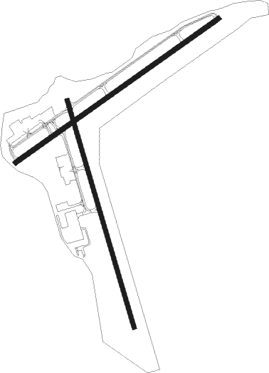
Runway info
Runway 18 / 36  | ||
| length | 1587m (5207ft) | |
| bearing | 164° / 344° | |
| width | 30m (100ft) | |
| surface | asphalt | |
| blast zone | 91m (299ft) / 10m (33ft) | |
| Runway 7 / 25 | ||
| length | 1673m (5489ft) | |
| bearing | 67° / 247° | |
| width | 30m (100ft) | |
| surface | asphalt | |
Nearby beacons
| code | identifier | dist | bearing | frequency |
|---|---|---|---|---|
| LEB | DME | 4.9 | 59° | 113.70 |
| LAH | HANOVER (LEBANON) NDB | 7.1 | 59° | 276 |
| CNH | CLAREMONT NDB | 15.7 | 195° | 233 |
| MPV | MONTPELIER VOR/DME | 28.2 | 342° | 116.90 |
| DYO | SMUTO (RUTLAND) NDB | 28.7 | 277° | 221 |
| RUT | DME | 28.7 | 261° | 111 |
| LC | BLNAP (LACONIA) NDB | 33.8 | 97° | 328 |
| CON | CONCORD VOR/DME | 40 | 119° | 112.90 |
| CO | EPSOM (CONCORD) NDB | 48 | 121° | 216 |
| EEN | DME | 49.9 | 179° | 109.40 |
| GMA | MAHN (WHITEFIELD) NDB | 51.6 | 40° | 386 |
| MJ | FITZY (MANCHESTER) NDB | 56.9 | 135° | 209 |
| BTV | BURLINGTON VOR/DME | 59.8 | 311° | 117.50 |
| MHT | MANCHESTER VOR/DME | 61.1 | 129° | 114.40 |
| BJA | BURLINGTON TACAN | 62.9 | 315° | 112.40 |
| BT | HERRO (BURLINGTON) NDB | 68 | 314° | 382 |
Instrument approach procedures
| runway | airway (heading) | route (dist, bearing) |
|---|---|---|
| RW07 | CON (299°) | CON HAIZO (44mi, 280°) 5000ft KEZUP (5mi, 14°) 3900ft |
| RW07 | MPV (162°) | MPV EJOCA (34mi, 196°) 5000ft KEZUP (5mi, 127°) 3900ft |
| RNAV | KEZUP 3900ft CEHJI (5mi, 55°) 2800ft AKHOM (1mi, 55°) 2500ft JORAB (3mi, 53°) 1620ft ZERKI (3mi, 53°) 768ft (4642mi, 121°) 1003ft HOMUN (4639mi, 301°) ZIECH (9mi, 324°) 4000ft ZIECH (turn) | |
| RW18 | CABIP (209°) | CABIP JIKOR (9mi, 261°) 4700ft |
| RW18 | JIKOR (163°) | JIKOR 4700ft |
| RW18 | PAKTE (125°) | PAKTE JIKOR (9mi, 81°) 4700ft |
| RNAV | JIKOR 4700ft YASUP (6mi, 164°) 2900ft WONGI (3mi, 164°) 1840ft KLEB (4mi, 162°) 606ft (4642mi, 121°) 2050ft JIKOR (4647mi, 301°) 4700ft JIKOR (turn) 4700ft | |
| RW25 | CON (299°) | CON ULAKY (32mi, 319°) 5000ft ROMRE (5mi, 321°) 4800ft |
| RW25 | MPV (162°) | MPV ELHOY (22mi, 126°) 5000ft ROMRE (5mi, 141°) 4800ft |
| RNAV | ROMRE 4800ft SHYMO (6mi, 247°) 3400ft WEBIN (3mi, 247°) 2300ft KLEB (5mi, 245°) 628ft (4642mi, 121°) 1003ft ZIECH (4644mi, 301°) 4000ft ZIECH (turn) | |
| RW36 | CON (299°) | CON UNKER (30mi, 281°) 5000ft HIRER (7mi, 304°) 3500ft |
| RW36 | JAMMA (38°) | JAMMA HIRER (14mi, 56°) 3500ft |
| RNAV | HIRER 3500ft ZULAR (6mi, 27°) 2600ft OSICE (5mi, 4°) 819ft (4641mi, 121°) 1003ft UCEKA (4642mi, 301°) ZIECH (9mi, 357°) 4000ft ZIECH (turn) |
Disclaimer
The information on this website is not for real aviation. Use this data with the X-Plane flight simulator only! Data taken with kind consent from X-Plane 12 source code and data files. Content is subject to change without notice.