Leesburg - Leesburg Intl
Airport details
| Country | United States of America |
| State | Florida |
| Region | K7 |
| Airspace | Jacksonville Ctr |
| Municipality | Lake County |
| Elevation | 77ft (23m) |
| Timezone | GMT -5 |
| Coordinates | 28.82289, -81.80842 |
| Magnetic var | |
| Type | land |
| Available since | X-Plane v10.40 |
| ICAO code | KLEE |
| IATA code | LEE |
| FAA code | LEE |
Communication
| Leesburg Intl ASOS | 134.325 |
| Leesburg Intl GROUND | 121.725 |
| Leesburg Intl TOWER | 119.350 |
| Leesburg Intl ORLANDO Approach/Departure | 121.100 |
Nearby Points of Interest:
Mote-Morris House
-Old Lake County Courthouse
-Harry C. Duncan House
-Howey House
-Campbell House
-Ferran Park and the Alice McClelland Memorial Bandshell
-Clifford House
-William Kimbrough Pendleton House
-Purdy Villa
-Gould Hyde Norton House
-Moses J. Taylor House
-LaRoe Family Homestead Historic District
-Old Mount Dora Atlantic Coast Line Railroad Station
-Donnelly House
-Mount Dora Historic District
-Witherspoon Lodge of Free and Accepted Masons, No. 111
-James Riley Josselyn House
-Gen. Robert Bullock House
-Thomas R. Ayer House
-Alfred Ayer House
-Harper House
-Edge House
-Clermont Woman's Club
-Nelson and Company Historic District
-Waite-Davis House
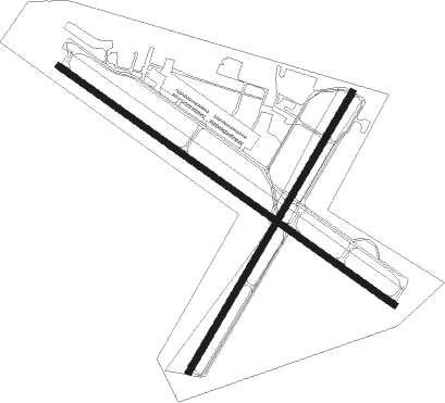
Runway info
Runway 13 / 31  | ||
| length | 1922m (6306ft) | |
| bearing | 126° / 306° | |
| width | 30m (100ft) | |
| surface | asphalt | |
| displ threshold | 91m (299ft) / 122m (400ft) | |
| Runway 3 / 21 | ||
| length | 1513m (4964ft) | |
| bearing | 38° / 218° | |
| width | 30m (100ft) | |
| surface | asphalt | |
| displ threshold | 0m (0ft) / 94m (308ft) | |
Nearby beacons
| code | identifier | dist | bearing | frequency |
|---|---|---|---|---|
| OR | HERNY (ORLANDO) NDB | 27.3 | 130° | 221 |
| ORL | ORLANDO VORTAC | 30 | 121° | 112.20 |
| OCF | OCALA VORTAC | 30.5 | 310° | 113.70 |
| OMN | ORMOND BEACH VORTAC | 46.5 | 55° | 112.60 |
| LAL | LAKELAND VORTAC | 51.4 | 194° | 116 |
| GN | WYNDS (GAINESVILLE) NDB | 54.3 | 337° | 269 |
| GNV | GATORS VORTAC | 57.5 | 332° | 116.20 |
| TP | COSME (TAMPA) NDB | 58.2 | 224° | 368 |
| PI | CAPOK(ST PETERSBURG-CLEARWATER NDB | 68.6 | 227° | 360 |
| MCF | MACDILL (TAMPA) TACAN | 68.7 | 216° | 111 |
| PIE | SAINT PETERSBURG VORTAC | 71.8 | 224° | 116.40 |
Departure and arrival routes
| Transition altitude | 18000ft |
| Transition level | 18000ft |
| STAR starting points | distance | inbound heading | |
|---|---|---|---|
| RW03 | |||
| PRICY1 | 46.8 | 12° | |
| TTHOR2 | 58.8 | 214° | |
| ALYNA1 | 41.0 | 273° | |
| RIDES1 | 66.2 | 322° | |
| GOOFY7 | 64.0 | 322° | |
| JOKRS2 | 47.5 | 354° | |
| MINEE5 | 42.4 | 355° | |
| RW13 | |||
| PRICY1 | 46.8 | 12° | |
| TTHOR2 | 58.8 | 214° | |
| ALYNA1 | 41.0 | 273° | |
| RIDES1 | 66.2 | 322° | |
| GOOFY7 | 64.0 | 322° | |
| JOKRS2 | 47.5 | 354° | |
| MINEE5 | 42.4 | 355° | |
| RW21 | |||
| PRICY1 | 46.8 | 12° | |
| TTHOR2 | 58.8 | 214° | |
| ALYNA1 | 41.0 | 273° | |
| GOOFY7 | 64.0 | 322° | |
| RIDES1 | 66.2 | 322° | |
| JOKRS2 | 47.5 | 354° | |
| MINEE5 | 42.4 | 355° | |
| RW31 | |||
| PRICY1 | 46.8 | 12° | |
| TTHOR2 | 58.8 | 214° | |
| ALYNA1 | 41.0 | 273° | |
| RIDES1 | 66.2 | 322° | |
| GOOFY7 | 64.0 | 322° | |
| JOKRS2 | 47.5 | 354° | |
| MINEE5 | 42.4 | 355° | |
Instrument approach procedures
| runway | airway (heading) | route (dist, bearing) |
|---|---|---|
| RW03 | JENSN (355°) | JENSN PUNQU (14mi, 346°) 2000ft JOXON (8mi, 302°) 2000ft |
| RW03 | MAMBO (292°) | MAMBO PUNQU (15mi, 229°) 2000ft JOXON (8mi, 302°) 2000ft |
| RNAV | JOXON 2000ft JUROT (7mi, 38°) 1800ft KLEE (6mi, 38°) 112ft (4974mi, 109°) 1000ft MAMBO (4964mi, 289°) 2000ft MAMBO (turn) | |
| RW13 | CERMO (358°) | CERMO RAVZE (20mi, 314°) 2000ft IBPEP (6mi, 43°) 2000ft |
| RW13 | MAMBO (292°) | MAMBO IBPEP (23mi, 299°) 2000ft IBPEP (turn) 2000ft |
| RW13 | OCF (130°) | OCF IBPEP (19mi, 133°) 2000ft |
| RNAV | IBPEP 2000ft ACMOF (6mi, 126°) 1800ft ZIRIL (2mi, 126°) 1100ft KLEE (4mi, 126°) 129ft (4974mi, 109°) 600ft MAMBO (4964mi, 289°) 2000ft MAMBO (turn) | |
| RW31 | EJOLA (306°) | EJOLA 2000ft |
| RW31 | JENSN (355°) | JENSN JELTT (15mi, 10°) 2000ft EJOLA (8mi, 43°) 2000ft |
| RW31 | KIZER (257°) | KIZER REFOZ (12mi, 230°) 2000ft EJOLA (8mi, 224°) 2000ft |
| RNAV | EJOLA 2000ft AKOJO (7mi, 306°) 1800ft MULKE (3mi, 306°) 860ft KLEE (3mi, 306°) 112ft (4974mi, 109°) 317ft IBPEP (4984mi, 289°) 2000ft IBPEP (turn) |
Holding patterns
| STAR name | hold at | type | turn | heading* | altitude | leg | speed limit |
|---|---|---|---|---|---|---|---|
| ALYNA1 | GRDON | VHF | right | 19 (199)° | DME 10.0mi | ICAO rules | |
| ALYNA1 | SURFR | VHF | left | 79 (259)° | DME 10.0mi | ICAO rules | |
| ALYNA1 | TIMIE | VHF | left | 19 (199)° | DME 10.0mi | ICAO rules | |
| GOOFY7 | BAIRN | VHF | right | 162 (342)° | < 17999ft | 1.0min timed | ICAO rules |
| JOKRS2 | FAZES | VHF | left | 169 (349)° | DME 10.0mi | ICAO rules | |
| JOKRS2 | MOANS | VHF | left | 183 (3)° | < 17999ft | 1.0min timed | ICAO rules |
| MINEE5 | DOWNN | VHF | left | 183 (3)° | 1.0min timed | ICAO rules | |
| MINEE5 | MINEE | VHF | right | 240 (60)° | < 17999ft | 1.0min timed | ICAO rules |
| MINEE5 | MOANS | VHF | left | 183 (3)° | < 17999ft | 1.0min timed | ICAO rules |
| PRICY1 | CHIVE | VHF | right | 273 (93)° | DME 10.0mi | ICAO rules | |
| PRICY1 | DAAWG | VHF | right | 272 (92)° | DME 10.0mi | ICAO rules | |
| PRICY1 | DECKS | VHF | right | 276 (96)° | DME 10.0mi | ICAO rules | |
| PRICY1 | DOZES | VHF | right | 250 (70)° | DME 10.0mi | ICAO rules | |
| PRICY1 | PRICY | VHF | right | 252 (72)° | DME 10.0mi | ICAO rules | |
| RIDES1 | RIDES | VHF | left | 164 (344)° | DME 10.0mi | ICAO rules | |
| RIDES1 | ZALUP | VHF | right | 125 (305)° | DME 10.0mi | ICAO rules | |
| TTHOR2 | LPERD | VHF | right | 14 (194)° | DME 10.0mi | ICAO rules | |
| TTHOR2 | WEEEK | VHF | left | 2 (182)° | DME 10.0mi | ICAO rules | |
| *) magnetic outbound (inbound) holding course | |||||||
Disclaimer
The information on this website is not for real aviation. Use this data with the X-Plane flight simulator only! Data taken with kind consent from X-Plane 12 source code and data files. Content is subject to change without notice.