Lemmon - Lemmon Muni
Airport details
| Country | United States of America |
| State | South Dakota |
| Region | K3 |
| Airspace | Minneapolis Ctr |
| Municipality | Perkins County |
| Elevation | 2570ft (783m) |
| Timezone | GMT -7 |
| Coordinates | 45.91838, -102.10554 |
| Magnetic var | |
| Type | land |
| Available since | X-Plane v10.40 |
| ICAO code | KLEM |
| IATA code | LEM |
| FAA code | LEM |
Communication
| Lemmon Muni CTAF/UNICOM | 122.800 |
Nearby Points of Interest:
Lemmon Petrified Park
-Adams County Courthouse
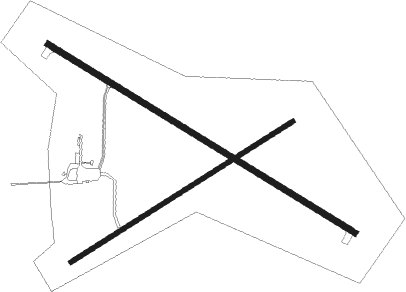
Runway info
Runway 11 / 29  | ||
| length | 1369m (4491ft) | |
| bearing | 117° / 297° | |
| width | 23m (75ft) | |
| surface | asphalt | |
| Runway 7 / 25 | ||
| length | 997m (3271ft) | |
| bearing | 70° / 250° | |
| width | 18m (60ft) | |
| surface | grass | |
Nearby beacons
| code | identifier | dist | bearing | frequency |
|---|---|---|---|---|
| LEM | LEMMON VOR | 0.1 | 54° | 111.40 |
| DPR | DUPREE VOR/DME | 53 | 155° | 116.80 |
| DIK | DICKINSON VORTAC | 62.9 | 325° | 112.90 |
Instrument approach procedures
| runway | airway (heading) | route (dist, bearing) |
|---|---|---|
| RW30 | CODTO (297°) | CODTO 4500ft |
| RNAV | CODTO 4500ft RAYNY (7mi, 297°) 4200ft KLEM (5mi, 296°) 2610ft (5909mi, 114°) 3300ft CODTO (5900mi, 294°) 4500ft CODTO (turn) |
Disclaimer
The information on this website is not for real aviation. Use this data with the X-Plane flight simulator only! Data taken with kind consent from X-Plane 12 source code and data files. Content is subject to change without notice.