Lafayette - Lafayette Regl
Airport details
| Country | United States of America |
| State | Louisiana |
| Region | K4 |
| Municipality | Lafayette |
| Elevation | 41ft (12m) |
| Timezone | GMT -6 |
| Coordinates | 30.20503, -91.98775 |
| Magnetic var | |
| Type | land |
| Available since | X-Plane v10.40 |
| ICAO code | KLFT |
| IATA code | LFT |
| FAA code | LFT |
Communication
| Lafayette Regl ATIS | 134.050 |
| Lafayette Regl CTAF | 118.500 |
| Lafayette Regl UNICOM | 122.950 |
| Lafayette Regl Clearance DEL | 125.550 |
| Lafayette Regl Ground Control | 121.800 |
| Lafayette Regl Tower | 118.500 |
| Lafayette Regl Approach/Departure | 121.100 |
| Lafayette Regl Approach/Departure | 128.700 |
Approach frequencies
| ILS-cat-I | RW22L | 109.5 | 18.00mi |
| ILS-cat-I | RW04R | 110.9 | 18.00mi |
| 3° GS | RW22L | 109.5 | 18.00mi |
| 3° GS | RW04R | 110.9 | 18.00mi |
Nearby Points of Interest:
Freetown-Port Rico Historic District
-Old Lafayette City Hall
-Brandt House (Lafayette, Louisiana)
-Maison Olivier
-Longfellow-Evangeline State Historic Site
-Dr. Joseph Angel Villien House
-Fontenette-Bienvenu House
-St. Martin Parish Courthouse
-Chretien Point Plantation
-Joseph Jefferson House
-Joseph D. Bernard House
-Shadows-on-the-Teche
-New Iberia High School
-Conrad Rice Mill
-St. Mary Congregational Church
-Le Vieux Presbytere
-Edward Benjamin Dubuisson House
-Bayside
-LeJeune's Bakery
-Albania Plantation House
-Bank of Gueydan
-El Dorado Plantation
-Istre Cemetery Grave Houses
-Alexis LaTour House
-Evangeline Bank and Trust Company
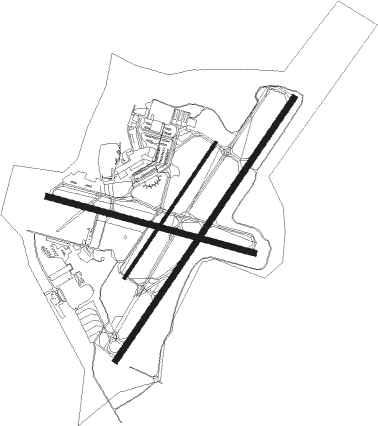
Runway info
Runway 4R / 22L  | ||
| length | 2441m (8009ft) | |
| bearing | 43° / 223° | |
| width | 46m (150ft) | |
| surface | asphalt | |
| displ threshold | 0m (0ft) / 104m (341ft) | |
| blast zone | 183m (600ft) / 31m (102ft) | |
| Runway 11 / 29 | ||
| length | 1644m (5394ft) | |
| bearing | 107° / 287° | |
| width | 45m (148ft) | |
| surface | asphalt | |
| Runway 4L / 22R | ||
| length | 1251m (4104ft) | |
| bearing | 43° / 223° | |
| width | 23m (75ft) | |
| surface | asphalt | |
Nearby beacons
| code | identifier | dist | bearing | frequency |
|---|---|---|---|---|
| LFT | LAFAYETTE VORTAC | 0.7 | 203° | 109.80 |
| LF | LAFFS (LAFARETTE) NDB | 6.5 | 43° | 375 |
| BNZ | ABBEVILLE NDB | 11.1 | 223° | 230 |
| ECY | DURALDE (EUNICE) NDB | 31.9 | 308° | 263 |
| LLA | WHITE LAKE VOR/DME | 38.2 | 215° | 110.40 |
| LSU | FIGHTING TIGER (BATON ROU VORTAC | 39.6 | 68° | 116.50 |
| BT | RUNDI (BATON ROUGE) NDB | 46.1 | 64° | 284 |
Instrument approach procedures
| runway | airway (heading) | route (dist, bearing) |
|---|---|---|
| RW04R | AYOTY (42°) | AYOTY 2000ft |
| RNAV | AYOTY 2000ft LAPNE (7mi, 43°) 1800ft KLFT (6mi, 42°) 88ft (5508mi, 108°) 317ft BEDDY (5497mi, 288°) 2000ft BEDDY (turn) | |
| RW22L | BOZAN (141°) | BOZAN KEBVE (18mi, 87°) 2000ft BEDDY (8mi, 125°) 2000ft |
| RW22L | MYRIC (275°) | MYRIC NEYID (16mi, 314°) 2000ft BEDDY (8mi, 305°) 2000ft |
| RNAV | BEDDY 2000ft JILEV (12mi, 223°) 2000ft KLFT (7mi, 224°) 87ft (5508mi, 108°) 233ft AYOTY (5517mi, 288°) 2000ft AYOTY (turn) | |
| RW29 | SPILL (288°) | SPILL 2100ft |
| RNAV | SPILL 2100ft ATCHA (6mi, 288°) 1700ft TODNE (3mi, 288°) 880ft KLFT (3mi, 288°) 87ft (5508mi, 108°) 292ft SUVDE (5511mi, 288°) RAYNE (13mi, 275°) 2800ft RAYNE (turn) |
Disclaimer
The information on this website is not for real aviation. Use this data with the X-Plane flight simulator only! Data taken with kind consent from X-Plane 12 source code and data files. Content is subject to change without notice.