Little Rock - Little Rock Clinton Natl
Airport details
| Country | United States of America |
| State | Arkansas |
| Region | K4 |
| Airspace | Memphis Ctr |
| Municipality | Little Rock |
| Elevation | 262ft (80m) |
| Timezone | GMT -6 |
| Coordinates | 34.72944, -92.22478 |
| Magnetic var | |
| Type | land |
| Available since | X-Plane v10.40 |
| ICAO code | KLIT |
| IATA code | LIT |
| FAA code | LIT |
Communication
| Little Rock Clinton Natl ATIS | 125.650 |
| Little Rock Clinton Natl UNICOM | 122.950 |
| Little Rock Clinton Natl Clearance DEL | 118.950 |
| Little Rock Clinton Natl Ground Control | 121.900 |
| Little Rock Clinton Natl Tower | 118.700 |
| Little Rock Clinton Natl LITTLE ROCK Approach/Departure | 119.500 |
| Little Rock Clinton Natl LITTLE ROCK Approach/Departure | 135.400 |
Approach frequencies
| ILS-cat-III | RW22R | 110.3 | 18.00mi |
| ILS-cat-I | RW22L | 110.7 | 18.00mi |
| ILS-cat-I | RW04R | 111.3 | 18.00mi |
| ILS-cat-I | RW04L | 110.3 | 18.00mi |
| 3° GS | RW22R | 110.3 | 18.00mi |
| 3° GS | RW22L | 110.7 | 18.00mi |
| 3° GS | RW04R | 111.3 | 18.00mi |
| 3° GS | RW04L | 110.3 | 18.00mi |
Nearby Points of Interest:
Climber Motor Car Factory, Unit A
-Harris House
-Little Rock Confederate Memorial
-East End Methodist Episcopal Church
-Stebbins and Roberts Office Building and Factory
-Hanger Hill Historic District
-Reichardt House
-Oakland-Fraternal Cemetery
-William Woodruff House
-Bechle Apartment Building
-Choctaw Route Station
-St. Edwards Church
-Pike-Fletcher-Terry House
-Johnson House
-Curran Hall
-Angelo Marre House
-Rock Island-Argenta Depot
-Trapnall Hall
-Baer House
-Nash House
-Tuf Nut Historic Commercial District
-Terminal Warehouse Building
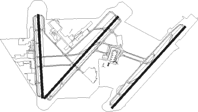
Runway info
Runway 4L / 22R  | ||
| length | 2522m (8274ft) | |
| bearing | 52° / 232° | |
| width | 46m (150ft) | |
| surface | concrete | |
| displ threshold | 91m (299ft) / 0m (0ft) | |
| blast zone | 137m (449ft) / 61m (200ft) | |
| Runway 4R / 22L | ||
| length | 2513m (8245ft) | |
| bearing | 52° / 232° | |
| width | 46m (150ft) | |
| surface | concrete | |
| displ threshold | 320m (1050ft) / 0m (0ft) | |
| blast zone | 61m (200ft) / 61m (200ft) | |
| Runway 18 / 36 | ||
| length | 1903m (6243ft) | |
| bearing | 182° / 2° | |
| width | 46m (150ft) | |
| surface | concrete | |
| displ threshold | 0m (0ft) / 31m (102ft) | |
| blast zone | 0m (0ft) / 64m (210ft) | |
Nearby beacons
| code | identifier | dist | bearing | frequency |
|---|---|---|---|---|
| LIT | LITTLE ROCK VORTAC | 3.8 | 139° | 113.90 |
| LI | LASKY (LITTLE ROCK) NDB | 5.3 | 233° | 353 |
| LRF | JACKSONVILLE TACAN | 11.8 | 20° | 109.20 |
| PBF | PINE BLUFF VOR/DME | 32.5 | 148° | 116 |
| DS | CERCY (SEARCY) NDB | 32.8 | 50° | 375 |
| TT | STUTT (STUTTGART) NDB | 34.5 | 109° | 338 |
| HOT | HOT SPRINGS VOR/DME | 45.3 | 254° | 110 |
| HO | HOSSY (HOT SPRINGS) NDB | 51.1 | 252° | 385 |
| RUE | RUSSELLVILLE NDB | 53.2 | 301° | 379 |
| BV | ALMND (BATESVILLE) NDB | 62.1 | 24° | 335 |
Instrument approach procedures
| runway | airway (heading) | route (dist, bearing) |
|---|---|---|
| RW04L | EJYIB (26°) | EJYIB KUSEJ (6mi, 311°) 2900ft |
| RW04L | KUSEJ (53°) | KUSEJ 2900ft |
| RW04L | NAZXO (73°) | NAZXO KUSEJ (5mi, 131°) 2900ft |
| RNAV | KUSEJ 2900ft RIWLO (6mi, 52°) 2000ft WEBVA (3mi, 52°) 960ft KLIT (3mi, 55°) 300ft (5515mi, 111°) 544ft ODXIH (5511mi, 291°) BRAUM (8mi, 57°) 2900ft BRAUM (turn) | |
| RW04R | BARBO (49°) | BARBO 2900ft |
| RW04R | EJYIB (26°) | EJYIB BARBO (5mi, 311°) 2900ft |
| RW04R | NAZXO (73°) | NAZXO BARBO (6mi, 131°) 2900ft |
| RNAV | BARBO 2900ft MYNIE (6mi, 52°) 2200ft ZULAD (4mi, 52°) 960ft KLIT (2mi, 38°) 309ft (5515mi, 111°) 574ft RIRIW (5510mi, 291°) BRAUM (8mi, 52°) 2900ft BRAUM (turn) | |
| RW18 | BIBBS (120°) | BIBBS ALMOW (20mi, 95°) 2700ft |
| RW18 | DUMPI (232°) | DUMPI ALMOW (13mi, 269°) 2700ft |
| RW18 | LIT (319°) | LIT ALMOW (15mi, 349°) 2700ft ALMOW (turn) 2700ft |
| RNAV | ALMOW 2700ft RUZAL (7mi, 182°) 1900ft ZEDEB (3mi, 182°) 1040ft KLIT (3mi, 166°) 309ft (5515mi, 111°) 666ft FEHXE (5516mi, 291°) 4000ft FEHXE (turn) 4000ft | |
| RW22L | PAZYA (208°) | PAZYA UTEWE (6mi, 131°) 2900ft |
| RW22L | UTEWE (234°) | UTEWE 2900ft |
| RW22L | WIGXO (254°) | WIGXO UTEWE (5mi, 311°) 2900ft |
| RNAV | UTEWE 2900ft RIRIW (6mi, 232°) 2000ft KLIT (6mi, 237°) 309ft (5515mi, 111°) 542ft MYNIE (5519mi, 291°) BAUDE (13mi, 230°) 2900ft BAUDE (turn) | |
| RW22R | PAZYA (208°) | PAZYA VAGXA (5mi, 131°) 2900ft |
| RW22R | VAGXA (231°) | VAGXA 2900ft |
| RW22R | WIGXO (254°) | WIGXO VAGXA (6mi, 311°) 2900ft |
| RNAV | VAGXA 2900ft ODXIH (6mi, 232°) 2100ft KLIT (6mi, 231°) 321ft (5515mi, 111°) 462ft RIWLO (5519mi, 291°) BAUDE (13mi, 226°) 2900ft BAUDE (turn) | |
| RW36 | BAQXI (27°) | BAQXI FEHXE (5mi, 91°) 3300ft |
| RW36 | DOVQA (342°) | DOVQA FEHXE (5mi, 271°) 3300ft |
| RW36 | FEHXE (5°) | FEHXE 3300ft |
| RNAV | FEHXE 3300ft KAGBE (9mi, 2°) 2000ft KLIT (6mi, 10°) 304ft (5515mi, 111°) 666ft HIGHS (5507mi, 291°) 2700ft HIGHS (turn) |
Disclaimer
The information on this website is not for real aviation. Use this data with the X-Plane flight simulator only! Data taken with kind consent from X-Plane 12 source code and data files. Content is subject to change without notice.