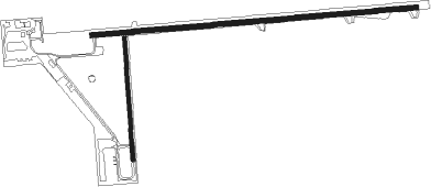
Lone Rock - Tri-county Regional
Airport details
| Country | United States of America |
| State | Wisconsin |
| Region | K5 |
| Airspace | Chicago Ctr |
| Municipality | Town of Spring Green |
| Elevation | 715ft (218m) |
| Timezone | GMT -6 |
| Coordinates | 43.21186, -90.17983 |
| Magnetic var | |
| Type | land |
| Available since | X-Plane v10.40 |
| ICAO code | KLNR |
| IATA code | LNR |
| FAA code | LNR |
Communication
| Tri-County Regional ASOS | 119.425 |
| Tri-County Regional CTAF/UNICOM | 123.000 |
| Tri-County Regional MADISON Approach/Departure | 135.450 |
Approach frequencies
| LOC | RW27 | 108.35 | 18.00mi |
Nearby Points of Interest:
Avoca River-Bottom Prairie
-Tower Hill State Park
-Court Street Commercial Historic District
-Julia B. and Fred P. Bowen House
-Hyde Chapel
-David J. and Maggie Jones House
-Our Lady of Loretto Roman Catholic Church and Cemetery
-Old Rock School
-Iowa County Courthouse
-Iowa Street Historic District
-Salem Evangelical Church
-Plum Grove Primitive Methodist Church
-Grove Street Historic District
-Cassidy Farmhouse
-Roberts House
-Kittleson House
-Mazomanie Downtown Historic District
-Tippesaukee Farm Rural Historic District
-Fort Blue Mounds
-Heiney's Meat Market
-John and Margarethe Kemp Cabin
-Van Hise Rock
-Wisconsin Heights Battlefield
-William Stolte, Sr., House
-William Stolte, Jr., House
Nearby beacons
| code | identifier | dist | bearing | frequency |
|---|---|---|---|---|
| LNR | ROCK DME | 5.3 | 29° | 116.05 |
| DLL | DELLS (BARABOO) VORTAC | 27.2 | 51° | 117 |
| MSN | MADISON VORTAC | 37 | 95° | 108.60 |
| VOK | VOLK (CAMP DOUGLAS) TACAN | 44 | 354° | 110.40 |
| CMY | MC COY NDB | 48 | 328° | 412 |
| DAF | NECEDAH NDB | 49.5 | 7° | 233 |
| DBQ | DUBUQUE VORTAC | 53.9 | 213° | 115.80 |
| DB | ZILOM (DUBUQUE) NDB | 56.4 | 205° | 341 |
| RFD | DME | 73.3 | 135° | 110.80 |
Instrument approach procedures
| runway | airway (heading) | route (dist, bearing) |
|---|---|---|
| RW09 | DALEY (308°) | DALEY GESLE (32mi, 287°) 3000ft FINKO (6mi, 359°) 3000ft |
| RW09 | DLL (231°) | DLL CEBLU (34mi, 251°) 3000ft FINKO (6mi, 179°) 3000ft |
| RW09 | FINKO (90°) | FINKO 3000ft |
| RNAV | FINKO 3000ft ESEVE (6mi, 90°) 2600ft KLNR (6mi, 90°) 750ft (5413mi, 116°) 994ft CABIG (5401mi, 296°) 3000ft CABIG (turn) | |
| RW27 | DALEY (308°) | DALEY CABIG (19mi, 340°) 3200ft CABIG (turn) 3000ft |
| RW27 | DLL (231°) | DLL CABIG (21mi, 202°) 3000ft |
| RW27 | MSN (275°) | MSN CABIG (25mi, 277°) 3000ft |
| RNAV | CABIG 3000ft DIYAS (6mi, 270°) 2600ft CEKDO (3mi, 270°) 1680ft KLNR (3mi, 269°) 750ft (5413mi, 116°) 1117ft FINKO (5425mi, 296°) 3000ft FINKO (turn) |
Disclaimer
The information on this website is not for real aviation. Use this data with the X-Plane flight simulator only! Data taken with kind consent from X-Plane 12 source code and data files. Content is subject to change without notice.

