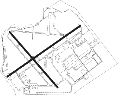
Louisville - Bowman Fld
Airport details
| Country | United States of America |
| State | Kentucky |
| Region | K5 |
| Airspace | Indianapolis Ctr |
| Municipality | Louisville |
| Elevation | 543ft (166m) |
| Timezone | GMT -5 |
| Coordinates | 38.22798, -85.66375 |
| Magnetic var | |
| Type | land |
| Available since | X-Plane v10.40 |
| ICAO code | KLOU |
| IATA code | LOU |
| FAA code | LOU |
Communication
| Bowman Fld CTAF | 119.500 |
| Bowman Fld UNICOM | 122.950 |
| Bowman Fld Ground Control | 121.800 |
| Bowman Fld Tower | 119.500 |
| Bowman Fld LOUISVILLE Approach/Departure | 132.075 |
| Bowman Fld LOUISVILLE Approach/Departure | 123.675 |
Nearby Points of Interest:
Bowman Field
-Masonic Widows and Orphans Home
-Commodore Apartment Building
-Dr. John Lewis House
-Bullock-Clifton House
-Peterson Avenue Hill
-Crescent Hill Branch Library
-Original Highlands
-Schuster Building
-Ridgeway
-Cherokee Triangle
-Crescent Hill
-Repton
-Oxmoor Farm
-Union Monument in Louisville
-Zachary Taylor House
-Butchertown
-St. Elizabeth of Hungary Roman Catholic Church
-Smoketown
-Midlands
-Lincliff
-Henry French House
-St. Paul's German Evangelical Church
-Boxhill
-College Street Presbyterian Church
Nearby beacons
| code | identifier | dist | bearing | frequency |
|---|---|---|---|---|
| BQM | (LOUISVILLE) DME | 0.1 | 336° | 112.20 |
| LK | LAANG (LOUISVILLE) NDB | 5.1 | 160° | 414 |
| IIU | LOUISVILLE VORTAC | 8.5 | 145° | 114.80 |
| JV | CATCH (JEFFERSONVILLE) NDB | 15.1 | 343° | 331 |
| FTK | FORT KNOX VOR/DME | 24.1 | 224° | 109.60 |
| GVR | (MADISON) DME | 33.1 | 20° | 114.65 |
| MYS | MYSTIC VOR | 34 | 240° | 108.20 |
| FFT | FRANKFORT VOR | 35.7 | 93° | 109.40 |
| EWO | NEW HOPE VOR/DME | 35.8 | 181° | 110.80 |
| DVK | GOODALL (DANVILLE) NDB | 57.8 | 126° | 311 |
| CVG | CINCINNATI VORTAC | 65.3 | 51° | 117.30 |
| OOM | HOOSIER (BLOOMINGTON) VORTAC | 70.7 | 314° | 110.20 |
Departure and arrival routes
| Transition altitude | 18000ft |
| Transition level | 18000ft |
| STAR starting points | distance | inbound heading | |
|---|---|---|---|
| ALL | |||
| CHERI4 | 40.1 | 90° | |
| RDSTN6 | 19.4 | 246° | |
| DARBY7 | 48.1 | 309° | |
Instrument approach procedures
| runway | airway (heading) | route (dist, bearing) |
|---|---|---|
| RW24 | NUNYA (245°) | NUNYA 3000ft |
| RNAV | NUNYA 3000ft BNNUS (5mi, 245°) 2300ft RUHEE (3mi, 245°) 1220ft KLOU (2mi, 245°) 587ft (5201mi, 114°) 1100ft CAANT (5194mi, 294°) 3000ft CAANT (turn) | |
| RW33 | ANDYE (341°) | ANDYE CAANT (5mi, 40°) 3000ft |
| RW33 | CAANT (317°) | CAANT 3000ft |
| RW33 | IFALN (290°) | IFALN CAANT (6mi, 241°) 3000ft |
| RNAV | CAANT 3000ft GDUPP (5mi, 317°) 2300ft PUXOJ (3mi, 317°) 1200ft KLOU (2mi, 319°) 561ft (5201mi, 114°) 1000ft ZOPOM (5191mi, 294°) 3000ft ZOPOM (turn) |
Holding patterns
| STAR name | hold at | type | turn | heading* | altitude | leg | speed limit |
|---|---|---|---|---|---|---|---|
| CHERI4 | CHERI | VHF | left | 279 (99)° | 1.0min timed | ICAO rules | |
| DARBY7 | DARBY | VHF | right | 132 (312)° | 1.0min timed | ICAO rules | |
| RDSTN6 | CVG | NDB | right | 59 (239)° | DME 4.0mi | ICAO rules | |
| RDSTN6 | NERVE | VHF | left | 41 (221)° | 1.0min timed | ICAO rules | |
| RDSTN6 | ZOPOM | VHF | left | 36 (216)° | 1.0min timed | ICAO rules | |
| *) magnetic outbound (inbound) holding course | |||||||
Disclaimer
The information on this website is not for real aviation. Use this data with the X-Plane flight simulator only! Data taken with kind consent from X-Plane 12 source code and data files. Content is subject to change without notice.

