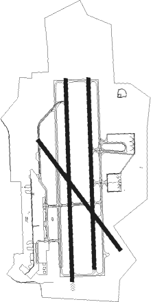
Laredo - Laredo Intl
Airport details
| Country | United States of America |
| State | Texas |
| Region | K4 |
| Airspace | Houston Oceanic Ctr |
| Municipality | Laredo |
| Elevation | 505ft (154m) |
| Timezone | GMT -6 |
| Coordinates | 27.54420, -99.46159 |
| Magnetic var | |
| Type | land |
| Available since | X-Plane v10.40 |
| ICAO code | KLRD |
| IATA code | LRD |
| FAA code | LRD |
Communication
| Laredo Intl ATIS | 125.775 |
| Laredo Intl CTAF | 120.100 |
| Laredo Intl UNICOM | 122.950 |
| Laredo Intl Ground Control | 121.800 |
| Laredo Intl Tower | 120.100 |
| Laredo Intl Houston Center | 127.800 |
Approach frequencies
| ILS-cat-I | RW18R | 111.9 | 18.00mi |
| 3° GS | RW18R | 111.9 | 18.00mi |
Nearby Points of Interest:
Barrio Azteca Historic District
-Webb County Courthouse
-Laredo United States Post Office, Court House and Custom House
-San Agustin de Laredo Historic District
-Laredo Convent Avenue Port of Entry
-Trevino-Uribe Rancho
Runway info
Nearby beacons
| code | identifier | dist | bearing | frequency |
|---|---|---|---|---|
| LRD | LAREDO VORTAC | 4.5 | 146° | 117.40 |
| NLD | NEWLA (NUEVO LAREDO) VOR/DME | 8.3 | 225° | 112.60 |
| COT | COTULLA VORTAC | 58 | 20° | 115.80 |
Instrument approach procedures
| runway | airway (heading) | route (dist, bearing) |
|---|---|---|
| RW14 | HISIK (144°) | HISIK 3000ft |
| RNAV | HISIK 3000ft LEDIY (6mi, 144°) 2200ft KLRD (6mi, 144°) 560ft (5909mi, 105°) 758ft ZERIK (5903mi, 285°) 2500ft ZERIK (turn) | |
| RW18L | PUCIK (183°) | PUCIK 3000ft |
| RNAV | PUCIK 3000ft HOLOV (7mi, 183°) 2300ft CAYAR (4mi, 183°) 1180ft KLRD (3mi, 185°) 550ft (5909mi, 105°) 1000ft ELKOS (5898mi, 285°) 2500ft ELKOS (turn) | |
| RW18R | KAHAN (210°) | KAHAN OVOSE (7mi, 257°) 3000ft |
| RW18R | OVOSE (182°) | OVOSE 3000ft |
| RNAV | OVOSE 3000ft JINSA (6mi, 183°) 2300ft ICANU (3mi, 183°) 1260ft KLRD (3mi, 181°) 561ft (5909mi, 105°) 1000ft ELKOS (5898mi, 285°) 2500ft ELKOS (turn) | |
| RW32 | KAHAN (210°) | KAHAN JUBSU (20mi, 155°) 3000ft LIYIS (10mi, 240°) 3000ft |
| RW32 | NELEE (319°) | NELEE LIYIS (19mi, 315°) 3000ft |
| RNAV | LIYIS 3000ft UCEPU (7mi, 324°) 1800ft YUGUB (2mi, 324°) 1120ft KLRD (2mi, 326°) 517ft (5909mi, 105°) 744ft HISIK (5914mi, 286°) 3000ft HISIK (turn) | |
| RW36L | KAHAN (210°) | KAHAN HUWLA (22mi, 165°) 3000ft WUGRO (7mi, 205°) 3000ft SOSOC (10mi, 272°) 3000ft |
| RW36L | NELEE (319°) | NELEE SOSOC (22mi, 296°) 3000ft |
| RNAV | SOSOC 3000ft JOBIX (7mi, 3°) 2400ft WAMUT (4mi, 3°) 1200ft KLRD (3mi, 5°) 535ft (5909mi, 105°) 697ft OVOSE (5907mi, 286°) 3000ft OVOSE (turn) |
Disclaimer
The information on this website is not for real aviation. Use this data with the X-Plane flight simulator only! Data taken with kind consent from X-Plane 12 source code and data files. Content is subject to change without notice.

