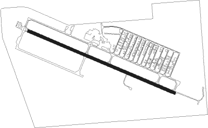
Minneapolis - Airlake
Airport details
| Country | United States of America |
| State | Minnesota |
| Region | K3 |
| Airspace | Minneapolis Ctr |
| Municipality | Lakeville |
| Elevation | 958ft (292m) |
| Timezone | GMT -6 |
| Coordinates | 44.62786, -93.22808 |
| Magnetic var | |
| Type | land |
| Available since | X-Plane v10.30 |
| ICAO code | KLVN |
| IATA code | n/a |
| FAA code | LVN |
Communication
| Airlake AWOS | 118.000 |
| Airlake CTAF/UNICOM | 123.000 |
| Airlake Minneapolis Dep | 134.700 |
Approach frequencies
| ILS-cat-I | RW30 | 108.9 | 18.00mi |
| 3° GS | RW30 | 108.9 | 18.00mi |
Nearby Points of Interest:
Emil J. Oberhoffer House
-Minneapolis Saint Paul Rochester & Dubuque Electric Traction Company Depot
-Church of the Annunciation-Catholic
-Wencl Kajer Farmstead
-District No. 72 School
-Goodsell Observatory
-Willis Hall
-Scoville Memorial Library
-Holz Family Farmstead
-Maka Yusota
-Gideon H. Pond House
-Archibald Mill
-Cedar Avenue Bridge
-Ault Store
-Church of the Most Holy Trinity (Catholic)
-Edward T. Archibald House
-Trondhjem Norwegian Lutheran Church
-Stanton Airfield
-Christdala Evangelical Swedish Lutheran Church
-Reuben Freeman House
-Saint Mary's Church of the Purification
-Fort Snelling National Cemetery
-Riley Lucas Bartholomew House
-John R. Cummins Farmhouse
-Third Street Bridge
Nearby beacons
| code | identifier | dist | bearing | frequency |
|---|---|---|---|---|
| FGT | FARMINGTON VORTAC | 1.9 | 86° | 115.70 |
| FCM | FLYING CLOUD (MINNEAPOLIS VOR/DME | 14.9 | 313° | 117.70 |
| MSP | MINNEAPOLIS VOR/DME | 16.1 | 358° | 115.30 |
| RG | REGUE (RED WING) NDB | 24.8 | 93° | 274 |
| FOW | HALFWAY (MORRISTOWN) VOR/DME | 26.1 | 199° | 111.20 |
| GEP | GOPHER (MINNEAPOLIS) VORTAC | 31.7 | 344° | 117.30 |
| OW | TONNA (OWATONNA) NDB | 33.4 | 173° | 379 |
| MKT | MANKATO VOR/DME | 38.2 | 239° | 110.80 |
| AEL | ALBERT LEA VOR/DME | 57.1 | 189° | 109.80 |
| RST | ROCHESTER VOR/DME | 57.5 | 143° | 112 |
| PNM | PRINCETON NDB | 58.5 | 338° | 368 |
| ST | HUSSK (ST CLOUD) NDB | 59.9 | 319° | 342 |
| STC | SAINT CLOUD VOR/DME | 65.5 | 318° | 112.10 |
Departure and arrival routes
| Transition altitude | 18000ft |
| Transition level | 18000ft |
| STAR starting points | distance | inbound heading | |
|---|---|---|---|
| ALL | |||
| ENCEE2 | 94.3 | 89° | |
| GEP1 | 70.4 | 157° | |
| AGUDE5 | 46.6 | 239° | |
Instrument approach procedures
| runway | airway (heading) | route (dist, bearing) |
|---|---|---|
| RW12 | JUNTU (110°) | JUNTU 3000ft |
| RNAV | JUNTU 3000ft YAVUK (6mi, 110°) 2600ft HOMGA (3mi, 110°) 1740ft KLVN (3mi, 110°) 1015ft (5543mi, 116°) 1211ft ZARPI (5533mi, 296°) 3600ft ZARPI (turn) | |
| RW30 | FGT (266°) | FGT TARKK (10mi, 116°) 3000ft TARKK (turn) 3000ft |
| RW30 | FOBUG (317°) | FOBUG TARKK (7mi, 22°) 3000ft |
| RW30 | PRESS (261°) | PRESS TARKK (17mi, 240°) 3000ft |
| RNAV | TARKK 3000ft FRRAN (6mi, 290°) 2600ft HINIS (2mi, 290°) 1820ft KLVN (3mi, 290°) 997ft (5543mi, 116°) 1152ft JUNTU (5553mi, 296°) 3000ft JUNTU (turn) |
Holding patterns
| STAR name | hold at | type | turn | heading* | altitude | leg | speed limit |
|---|---|---|---|---|---|---|---|
| AGUDE5 | BEERI | VHF | right | 127 (307)° | 1.0min timed | ICAO rules | |
| ENCEE2 | WOOOD | VHF | left | 251 (71)° | < 17999ft | DME 10.0mi | ICAO rules |
| GEP1 | GOLLF | VHF | left | 333 (153)° | < 17999ft | 1.0min timed | ICAO rules |
| TWOLF3 | TWOLF | VHF | left | 178 (358)° | < 17999ft | 1.0min timed | ICAO rules |
| *) magnetic outbound (inbound) holding course | |||||||
Disclaimer
The information on this website is not for real aviation. Use this data with the X-Plane flight simulator only! Data taken with kind consent from X-Plane 12 source code and data files. Content is subject to change without notice.
