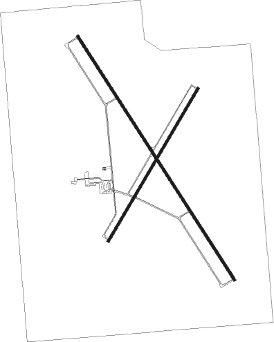
Las Vegas - Las Vegas Muni
Airport details
| Country | United States of America |
| State | New Mexico |
| Region | K2 |
| Airspace | Albuquerque Ctr |
| Municipality | San Miguel County |
| Elevation | 6876ft (2096m) |
| Timezone | GMT -7 |
| Coordinates | 35.65422, -105.14239 |
| Magnetic var | |
| Type | land |
| Available since | X-Plane v10.40 |
| ICAO code | KLVS |
| IATA code | LVS |
| FAA code | LVS |
Communication
| Las Vegas Muni ASOS | 118.525 |
| Las Vegas Muni CTAF/UNICOM | 122.800 |
Nearby Points of Interest:
Douglas-Sixth Street Historic District
-Lowery Clevenger House
-House at 915 2nd
-House at 919 2nd
-Bean-Newlee House
-Railroad Avenue Historic District (Las Vegas, New Mexico)
-House at 1513 8th
-James Cook House
-House at 16 Grand Avenue
-AT & SF Roundhouse
-Bridge Street Historic District
-Las Vegas Plaza
-Old Town Residential Historic District
-Presbyterian Mission Church
-Acequia Madre
-La Cueva Historic District
-Cassidy Mill
-Daniel Cassidy and Sons General Merchandise Store
-San Antonio de Padua Church
-Glorieta Pass Battlefield

Nearby beacons
| code | identifier | dist | bearing | frequency |
|---|---|---|---|---|
| FTI | FORT UNION VORTAC | 0.3 | 64° | 117.30 |
| ACH | ANTON CHICO VORTAC | 32.9 | 169° | 117.80 |
| SAF | SANTA FE VORTAC | 45.5 | 263° | 110.60 |
| CIM | CIMARRON VORTAC | 51.9 | 18° | 116.40 |
| OTO | OTTO VOR | 52.2 | 234° | 114 |
| TAS | TAOS VORTAC | 68.2 | 321° | 117.60 |
Instrument approach procedures
| runway | airway (heading) | route (dist, bearing) |
|---|---|---|
| RW02 | ACH (349°) | ACH WAMKA (20mi, 324°) 10000ft GAVLY (5mi, 324°) 10000ft |
| RW02 | FTI (244°) | FTI GAVLY (14mi, 221°) 10000ft GAVLY (turn) 10000ft |
| RW02 | TAFOY (54°) | TAFOY GAVLY (16mi, 64°) 10000ft |
| RNAV | GAVLY 10000ft LUGFE (7mi, 40°) 9000ft KLVS (7mi, 40°) 6906ft (6141mi, 109°) 7277ft ITBOW (6132mi, 289°) 10000ft ITBOW (turn) | |
| RW20 | CELAV (198°) | CELAV JEMAK (10mi, 176°) 11100ft ITBOW (5mi, 176°) 10000ft |
| RW20 | FTI (244°) | FTI ITBOW (13mi, 40°) 10000ft ITBOW (turn) 10000ft |
| RW20 | HOLSU (260°) | HOLSU ITBOW (14mi, 294°) 10000ft |
| RNAV | ITBOW 10000ft OVAZO (7mi, 221°) 9000ft SOPKE (5mi, 221°) 7400ft KLVS (2mi, 221°) 6901ft (6141mi, 109°) 7260ft GAVLY (6150mi, 289°) 10000ft GAVLY (turn) | |
| RW32 | ACH (349°) | ACH DOYEC (18mi, 349°) 10000ft HONAS (5mi, 66°) 10000ft |
| RW32 | FTI (244°) | FTI HONAS (14mi, 148°) 10000ft HONAS (turn) 10000ft |
| RW32 | HOLSU (260°) | HOLSU JEKIM (17mi, 218°) 10000ft HONAS (5mi, 246°) 10000ft |
| RW32 | TAFOY (54°) | TAFOY DOYEC (24mi, 81°) 10000ft HONAS (5mi, 66°) 10000ft |
| RNAV | HONAS 10000ft ZODES (7mi, 327°) 9000ft KLVS (7mi, 326°) 6917ft (6141mi, 109°) 7277ft HONAS (6137mi, 289°) 10000ft HONAS (turn) |
Disclaimer
The information on this website is not for real aviation. Use this data with the X-Plane flight simulator only! Data taken with kind consent from X-Plane 12 source code and data files. Content is subject to change without notice.