South Haven - South Haven Area Rgnl
Airport details
| Country | United States of America |
| State | Michigan |
| Region | K5 |
| Airspace | Chicago Ctr |
| Municipality | South Haven Charter Township |
| Elevation | 666ft (203m) |
| Timezone | GMT -5 |
| Coordinates | 42.35120, -86.25564 |
| Magnetic var | |
| Type | land |
| Available since | X-Plane v10.40 |
| ICAO code | KLWA |
| IATA code | LWA |
| FAA code | LWA |
Communication
| SOUTH HAVEN AREA RGNL AWOS 3 | 118.025 |
| SOUTH HAVEN AREA RGNL CTAF/UNICOM | 122.800 |
| SOUTH HAVEN AREA RGNL SOUTH BEND APCH | 118.550 |
| SOUTH HAVEN AREA RGNL SOUTH BEND Departure | 118.550 |
Nearby Points of Interest:
Liberty Hyde Bailey Birthplace
-Bangor Elevator
-North Watervliet Road – Paw Paw Lake Outlet Bridge
-Marshall's Store
-House of David
-Fidelity Building
-Shiloh House
-Wendell P. and Harriet Rounds Robbins House
-Ninth District Lighthouse Depot
-Hacklander Site
-St. Joseph North Pier Inner and Outer Lights
-St. Joseph North Pier Outer Light
-Lake Shore Chapel
-Van Buren County Courthouse
-Warner P. Sutton House
-All Saints Episcopal Church
-Rock S. Edwards Farmstead
-William H. Brown House
-Henry Franks House
-Hennepin
-Griswold Civic Center Historic District
-Dorr E. Felt Mansion
-Marshall Street Historic District
-Edward D. Born House
-Sarah Lowe Stedman House
Runway info
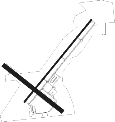
Runway 5 / 23  | ||
| length | 1463m (4800ft) | |
| bearing | 52° / 232° | |
| width | 23m (75ft) | |
| surface | asphalt | |
| Runway 14 / 32 | ||
| length | 1000m (3281ft) | |
| bearing | 124° / 304° | |
| width | 58m (190ft) | |
| surface | grass | |
| displ threshold | 294m (965ft) / 232m (761ft) | |
Nearby beacons
| code | identifier | dist | bearing | frequency |
|---|---|---|---|---|
| PMM | PULLMAN VOR/DME | 9.6 | 53° | 112.10 |
| ELX | KEELER VOR/DME | 13.7 | 147° | 116.60 |
| AZO | KALAMAZOO VOR/DME | 31.9 | 99° | 109 |
| AZ | AUSTN (KALAMAZOO) NDB | 34.8 | 107° | 371 |
| GIJ | GIPPER (NILES) VORTAC | 35.1 | 186° | 115.40 |
| SB | MISHA (SOUTH BEND) NDB | 38.8 | 177° | 341 |
| VIO | VICTORY VOR/DME | 42.5 | 60° | 115.95 |
| IRS | STURGIS NDB | 48.8 | 123° | 382 |
| MKG | MUSKEGON TACAN | 50 | 15° | 115.20 |
| GSH | GOSHEN VORTAC | 50.6 | 165° | 113.70 |
| GR | KNOBS (GRAND RAPIDS) NDB | 50.7 | 58° | 263 |
| VP | SEDLY (VALPARAISO) NDB | 60.7 | 215° | 212 |
Instrument approach procedures
| runway | airway (heading) | route (dist, bearing) |
|---|---|---|
| RW05 | ELX (327°) | ELX SUSOY (15mi, 279°) 4000ft SUSOY (turn) 4000ft |
| RW05 | PMM (233°) | PMM SUSOY (23mi, 232°) 4000ft SUSOY (turn) 4000ft |
| RW05 | YOLUR (61°) | YOLUR SUSOY (8mi, 75°) 4000ft |
| RW05 | ZIMEG (43°) | ZIMEG SUSOY (8mi, 25°) 4000ft |
| RNAV | SUSOY 4000ft NODCI (7mi, 52°) 2500ft LIVTE (4mi, 52°) 1360ft KLWA (2mi, 52°) 702ft (5239mi, 116°) 1020ft JUSRO (5230mi, 296°) 4000ft JUSRO (turn) 4000ft | |
| RW23 | ELX (327°) | ELX JUSRO (22mi, 11°) 4000ft JUSRO (turn) 4000ft |
| RW23 | OSEGO (261°) | OSEGO ZUBON (13mi, 280°) 4000ft JUSRO (7mi, 269°) 4000ft |
| RW23 | RAINE (125°) | RAINE JUSRO (20mi, 92°) 4000ft JUSRO (turn) 4000ft |
| RW23 | ZEELE (200°) | ZEELE RURDE (15mi, 177°) 4000ft JUSRO (7mi, 179°) 4000ft |
| RNAV | JUSRO 4000ft KIDTE (7mi, 232°) 2500ft PIXOE (3mi, 232°) 1500ft KLWA (3mi, 232°) 706ft (5239mi, 116°) 1060ft SUSOY (5248mi, 296°) 4000ft SUSOY (turn) 4000ft |
Disclaimer
The information on this website is not for real aviation. Use this data with the X-Plane flight simulator only! Data taken with kind consent from X-Plane 12 source code and data files. Content is subject to change without notice.