Malone - Malone-dufort
Airport details
| Country | United States of America |
| State | New York |
| Region | K6 |
| Airspace | Boston Ctr |
| Municipality | Town of Malone |
| Elevation | 790ft (241m) |
| Timezone | GMT -5 |
| Coordinates | 44.85367, -74.32894 |
| Magnetic var | |
| Type | land |
| Available since | X-Plane v10.40 |
| ICAO code | KMAL |
| IATA code | n/a |
| FAA code | MAL |
Communication
| Malone-Dufort CTAF/UNICOM | 122.800 |
Nearby Points of Interest:
Malone Armory
-United States Post Office
-Duane Methodist Episcopal Church
-Lac Saint-François National Wildlife Area
-Lake Saint Francis
-Hopkinton Green Historic District
-Dr. Buck–Stevens House
-Loon Lake Mountain Fire Observation Station
-Lyon Mountain Railroad Station
-Merrillsville Cure Cottage
-Brighton Town Hall
-Pont Jean-De La Lande
-Camp Topridge
-Coteau-du-Lac canal
-Hepburn Library
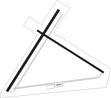
Runway info
Runway 5 / 23  | ||
| length | 1215m (3986ft) | |
| bearing | 47° / 227° | |
| width | 30m (100ft) | |
| surface | asphalt | |
| Runway 14 / 32 | ||
| length | 989m (3245ft) | |
| bearing | 118° / 298° | |
| width | 23m (75ft) | |
| surface | asphalt | |
Nearby beacons
| code | identifier | dist | bearing | frequency |
|---|---|---|---|---|
| MSS | MASSENA TACAN | 17.1 | 279° | 114.10 |
| PTD | POTSDAM NDB | 24.8 | 257° | 400 |
| MS | MISSE (MASSENA) NDB | 24.9 | 270° | 278 |
| SLK | LAKE DME | 28.6 | 165° | 109.20 |
| ZMR | HERMAS (MONTREAL) NDB | 47.4 | 17° | 272 |
| YUL | MONTREAL VOR/DME | 48.2 | 25° | 116.30 |
| ZMM | JOLY (MONTREAL) NDB | 50 | 10° | 266 |
| ZMX | JANVIER (MONTREAL) NDB | 56 | 25° | 317 |
| ZHU | HAUTS-BOIS (MONTREAL) NDB | 59.5 | 54° | 407 |
Instrument approach procedures
| runway | airway (heading) | route (dist, bearing) |
|---|---|---|
| RW05 | MITAH (47°) | MITAH 3600ft |
| RW05 | MUNZA (3°) | MUNZA WUVES (5mi, 315°) 4500ft MITAH (6mi, 315°) 3600ft |
| RW05 | SSENA (99°) | SSENA LIKME (12mi, 158°) 4500ft MITAH (6mi, 105°) 3600ft |
| RNAV | MITAH 3600ft NICVI (6mi, 46°) 2800ft ZELUV (3mi, 46°) 1820ft KMAL (3mi, 48°) 813ft (4742mi, 121°) 1190ft MITAH (4748mi, 301°) 3600ft MITAH (turn) | |
| RW23 | LETUS (78°) | LETUS LAIVS (56mi, 75°) 3000ft LAIVS (turn) 3000ft |
| RW23 | TRIKY (297°) | TRIKY ZALUM (10mi, 339°) 4700ft JORAR (9mi, 339°) 4000ft LAIVS (7mi, 272°) 3000ft |
| RNAV | LAIVS 3000ft DNWLS (5mi, 227°) 1800ft KMAL (3mi, 225°) 794ft (4742mi, 121°) 1155ft MITAH (4748mi, 301°) 3600ft MITAH (turn) |
Disclaimer
The information on this website is not for real aviation. Use this data with the X-Plane flight simulator only! Data taken with kind consent from X-Plane 12 source code and data files. Content is subject to change without notice.