Meridian - Key Fld
Airport details
| Country | United States of America |
| State | Mississippi |
| Region | K7 |
| Airspace | Memphis Ctr |
| Municipality | Meridian |
| Elevation | 295ft (90m) |
| Timezone | GMT -6 |
| Coordinates | 32.34918, -88.74666 |
| Magnetic var | |
| Type | land |
| Available since | X-Plane v10.40 |
| ICAO code | KMEI |
| IATA code | MEI |
| FAA code | MEI |
Communication
| KEY FLD ATIS | 126.475 |
| KEY FLD CTAF | 119.800 |
| KEY FLD UNICOM | 122.950 |
| KEY FLD Ground Control | 121.900 |
| KEY FLD Tower | 119.800 |
| KEY FLD MERIDIAN Approach/Departure | 120.500 |
| KEY FLD GCA | 125.125 |
Approach frequencies
| ILS-cat-I | RW19 | 111.35 | 18.00mi |
| ILS-cat-I | RW01 | 110.1 | 18.00mi |
| 3° GS | RW19 | 111.35 | 18.00mi |
| 3° GS | RW01 | 110.1 | 18.00mi |
Nearby Points of Interest:
Meridian Regional Airport
-Merrehope
-Elson-Dudley House
-Standard Drug Company
-Meridian City Hall
-Temple Theatre
-Masonic Temple
-Threefoot Building
-United States Post Office and Courthouse
-Dement Printing Company
-Cahn-Crawford House
-Porter-Crawford House
-Stuckey's Bridge
-Causeyville Historic District
-Quitman Depot
-Dr. James Alvis Beavers House
-Newton station
-Porterville General Store
-Old US Post Office
-Downtown Philadelphia Historic District
-Sumter County Courthouse
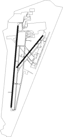
Runway info
Runway 1 / 19  | ||
| length | 3057m (10030ft) | |
| bearing | 11° / 191° | |
| width | 46m (150ft) | |
| surface | asphalt | |
| displ threshold | 305m (1001ft) / 305m (1001ft) | |
| blast zone | 255m (837ft) / 255m (837ft) | |
| Runway 4 / 22 | ||
| length | 1534m (5033ft) | |
| bearing | 49° / 229° | |
| width | 46m (150ft) | |
| surface | asphalt | |
Nearby beacons
| code | identifier | dist | bearing | frequency |
|---|---|---|---|---|
| MEI | MERIDIAN VORTAC | 3.4 | 297° | 117 |
| EWA | DME | 14.7 | 86° | 113.80 |
| NMM | MERIDIAN TACAN | 17.1 | 41° | 111.90 |
| LBY | EATON (HATTIESBURG) VORTAC | 63.4 | 212° | 110.60 |
Instrument approach procedures
| runway | airway (heading) | route (dist, bearing) |
|---|---|---|
| RW01 | ACZUP (12°) | ACZUP 2700ft |
| RNAV | ACZUP 2700ft MRVIN (7mi, 11°) 1800ft ZOROT (2mi, 11°) 1060ft KMEI (4mi, 14°) 342ft (5342mi, 110°) 800ft PAULD (5353mi, 290°) 3000ft PAULD (turn) | |
| RW04 | WEYKU (46°) | WEYKU 3200ft |
| RNAV | WEYKU 3200ft HOXAN (8mi, 49°) 2000ft JAVOP (3mi, 49°) 1160ft KMEI (4mi, 40°) 335ft (5342mi, 110°) 1300ft PAULD (5353mi, 290°) 3000ft PAULD (turn) | |
| RW19 | OVIVE (190°) | OVIVE 2700ft |
| RNAV | OVIVE 2700ft GOZAX (7mi, 191°) 1800ft HOLUN (2mi, 191°) 1200ft KMEI (2mi, 185°) 347ft (5342mi, 110°) 900ft PAULD (5353mi, 290°) 3000ft PAULD (turn) | |
| RW22 | WOXET (232°) | WOXET 3300ft |
| RNAV | WOXET 3300ft CUGOS (7mi, 229°) 1600ft KMEI (4mi, 237°) 349ft (5342mi, 110°) 1000ft PAULD (5353mi, 290°) 3000ft PAULD (turn) |
Disclaimer
The information on this website is not for real aviation. Use this data with the X-Plane flight simulator only! Data taken with kind consent from X-Plane 12 source code and data files. Content is subject to change without notice.