Mansfield - Mansfield Lahm Rgnl
Airport details
| Country | United States of America |
| State | Ohio |
| Region | K5 |
| Airspace | Cleveland Ctr |
| Municipality | Mansfield |
| Elevation | 1294ft (394m) |
| Timezone | GMT -5 |
| Coordinates | 40.81253, -82.51245 |
| Magnetic var | |
| Type | land |
| Available since | X-Plane v10.40 |
| ICAO code | KMFD |
| IATA code | MFD |
| FAA code | MFD |
Communication
| Mansfield Lahm Rgnl ATIS | 125.300 |
| Mansfield Lahm Rgnl UNICOM | 122.950 |
| Mansfield Lahm Rgnl CTAF | 119.800 |
| Mansfield Lahm Rgnl Ground Control | 121.800 |
| Mansfield Lahm Rgnl Tower | 119.800 |
| Mansfield Lahm Rgnl Approach/Departure | 127.350 |
| Mansfield Lahm Rgnl Approach/Departure | 124.200 |
Approach frequencies
| ILS-cat-I | RW32 | 110.5 | 18.00mi |
| 3° GS | RW32 | 110.5 | 18.00mi |
Nearby Points of Interest:
Anderson Schoolhouse
-Ashland County Courthouse
-Crittenden Farm
-Gregory House
-Raleigh Mound
-Crawford County Courthouse
-Huntington Grange
-Brown's Lake Bog
-United Church of Huntington
-Darlon Allen House
-Mosher House
-Knox County Courthouse
-Wayne County Courthouse District
-Huron County Courthouse and Jail
-Christ Church at the Quarry
-Carlos Avery House
-John Hosford House
-Zion Episcopal Church
-Croco House
Runway info
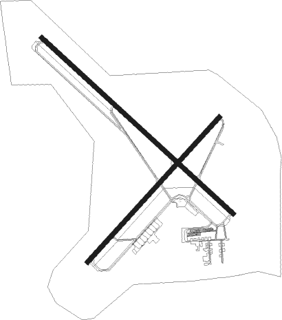
Runway 14 / 32  | ||
| length | 2742m (8996ft) | |
| bearing | 129° / 309° | |
| width | 46m (151ft) | |
| surface | asphalt | |
| blast zone | 45m (148ft) / 45m (148ft) | |
| Runway 5 / 23 | ||
| length | 2070m (6791ft) | |
| bearing | 55° / 235° | |
| width | 46m (151ft) | |
| surface | asphalt | |
| blast zone | 229m (751ft) / 137m (449ft) | |
Nearby beacons
| code | identifier | dist | bearing | frequency |
|---|---|---|---|---|
| MF | MANNS (MANSFIELD) NDB | 4.1 | 125° | 372 |
| MFD | MANSFIELD VORTAC | 4.9 | 306° | 108.80 |
| BUD | BUCKEYE (MARION) VOR | 27.7 | 250° | 109.80 |
| TII | TIFFIN NDB | 36 | 292° | 269 |
| DJB | DRYER VOR/DME | 36.4 | 33° | 113.60 |
| APE | APPLETON VORTAC | 39.8 | 187° | 116.70 |
| PCW | PORT CLINTON NDB | 45.3 | 333° | 423 |
| OS | FULER (COLUMBUS) NDB | 54.3 | 223° | 515 |
| LC | PICKL (COLUMBUS) NDB | 57.8 | 199° | 376 |
| ZZV | ZANESVILLE VOR/DME | 59.5 | 145° | 114.95 |
| BF | TABEY (CLEVELAND) NDB | 62.1 | 51° | 248 |
| BU | BOUTN (COLUMBUS) NDB | 67.5 | 215° | 230 |
Instrument approach procedures
| runway | airway (heading) | route (dist, bearing) |
|---|---|---|
| RW05 | DUSKY (99°) | DUSKY HUDOR (21mi, 109°) 3000ft JOKAM (6mi, 129°) 3000ft |
| RW05 | JOKAM (56°) | JOKAM 3000ft |
| RW05 | YOGUD (23°) | YOGUD JOKAM (6mi, 309°) 3000ft |
| RNAV | JOKAM 3000ft ZOLEL (6mi, 55°) 2700ft WOVOM (2mi, 55°) 2060ft KMFD (3mi, 61°) 1337ft (5065mi, 116°) 1547ft NANNI (5058mi, 296°) 3000ft NANNI (turn) | |
| RW14 | UPIYO (130°) | UPIYO 3000ft |
| RNAV | UPIYO 3000ft HUGIX (7mi, 129°) 2700ft WIMOS (3mi, 129°) 1820ft KMFD (3mi, 135°) 1288ft (5065mi, 116°) 1446ft PIRCI (5057mi, 296°) 3000ft PIRCI (turn) | |
| RW23 | CUDIR (259°) | CUDIR NANNI (6mi, 309°) 3000ft |
| RW23 | NANNI (233°) | NANNI 3000ft |
| RW23 | NEWLO (203°) | NEWLO UMTAW (5mi, 208°) 3000ft NANNI (6mi, 129°) 3000ft |
| RNAV | NANNI 3000ft IXHUP (6mi, 235°) 2700ft KMFD (5mi, 231°) 1321ft (5065mi, 116°) 1545ft JOKAM (5073mi, 296°) 3000ft JOKAM (turn) | |
| RW32 | HUSGI (336°) | HUSGI 3000ft PIRCI (5mi, 55°) 3000ft |
| RW32 | IDOBY (286°) | IDOBY 3000ft PIRCI (5mi, 235°) 3000ft |
| RW32 | PIRCI (308°) | PIRCI 3000ft |
| RNAV | PIRCI 3000ft OCOPO (6mi, 309°) 2700ft PUYIY (2mi, 309°) 1960ft KMFD (2mi, 301°) 1336ft (5065mi, 116°) 1490ft UPIYO (5075mi, 296°) 3000ft UPIYO (turn) |
Disclaimer
The information on this website is not for real aviation. Use this data with the X-Plane flight simulator only! Data taken with kind consent from X-Plane 12 source code and data files. Content is subject to change without notice.