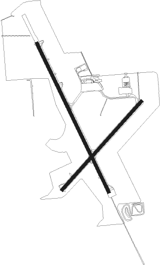
Marshfield - Marshfield Muni
Airport details
| Country | United States of America |
| State | Wisconsin |
| Region | K5 |
| Airspace | Minneapolis Ctr |
| Municipality | Marshfield |
| Elevation | 1274ft (388m) |
| Timezone | GMT -6 |
| Coordinates | 44.63688, -90.18933 |
| Magnetic var | |
| Type | land |
| Available since | X-Plane v10.40 |
| ICAO code | KMFI |
| IATA code | MFI |
| FAA code | MFI |
Communication
| Marshfield Muni ASOS | 121.575 |
| Marshfield Muni CTAF/UNICOM | 123.000 |
Nearby Points of Interest:
Willard D. Purdy Junior High and Vocational School
-Charles Foote House
-William B. and Jennie Tufts House
-Forrest D. and Marian Calway House
-Decatur and Kate Dickinson House
-John and Maria Hein House
-Neillsville Post Office
-Neillsville Downtown Historic District
-First Church of Christ, Scientist
-Neillsville Masonic Temple Lodge No. 163
-George W. and Sarah Trogner House
-Herman M. and Hanna Hediger House
-Robert Schofield House
-The Silver Dome Ballroom
-Joseph Dessert Library
-Karl Mathie House
-Owen High School

Nearby beacons
| code | identifier | dist | bearing | frequency |
|---|---|---|---|---|
| AUW | WAUSAU VOR/DME | 28.6 | 71° | 111.60 |
| DAF | NECEDAH NDB | 36.4 | 170° | 233 |
| VOK | VOLK (CAMP DOUGLAS) TACAN | 41.7 | 186° | 110.40 |
| CMY | MC COY NDB | 46.2 | 213° | 412 |
| RCX | RUSK COUNTY (LADYSMITH) NDB | 62.3 | 317° | 356 |
| RH | ARSHA (RHINELANDER) NDB | 64.2 | 30° | 272 |
| RHI | RHINELANDER VOR/DME | 67.4 | 36° | 109.20 |
Instrument approach procedures
| runway | airway (heading) | route (dist, bearing) |
|---|---|---|
| RW05 | YAJJU (55°) | YAJJU 3000ft |
| RNAV | YAJJU 3000ft ZOBER (7mi, 56°) 3000ft EVXAG (3mi, 56°) 1880ft KMFI (2mi, 53°) 1293ft (5413mi, 116°) 1640ft EXLIJ (5404mi, 296°) 3000ft EXLIJ (turn) | |
| RW16 | DUFOE (151°) | DUFOE 3000ft |
| RW16 | EDGRR (228°) | EDGRR EKTEY (9mi, 271°) 3000ft DUFOE (7mi, 251°) 3000ft |
| RNAV | DUFOE 3000ft SOWSU (6mi, 151°) 2900ft KMFI (5mi, 151°) 1323ft (5413mi, 116°) 1639ft VECSU (5409mi, 296°) 3000ft VECSU (turn) | |
| RW23 | EXLIJ (236°) | EXLIJ 3000ft |
| RNAV | EXLIJ 3000ft UWBUZ (7mi, 236°) 3000ft ASUYO (4mi, 236°) 1760ft KMFI (2mi, 239°) 1289ft (5413mi, 116°) 1640ft YAJJU (5422mi, 296°) 3000ft YAJJU (turn) |
Disclaimer
The information on this website is not for real aviation. Use this data with the X-Plane flight simulator only! Data taken with kind consent from X-Plane 12 source code and data files. Content is subject to change without notice.