Montgomery - Orange County
Airport details
| Country | United States of America |
| State | New York |
| Region | K6 |
| Airspace | Boston Ctr |
| Municipality | Town of Montgomery |
| Elevation | 370ft (113m) |
| Timezone | GMT -5 |
| Coordinates | 41.50999, -74.26464 |
| Magnetic var | |
| Type | land |
| Available since | X-Plane v10.40 |
| ICAO code | KMGJ |
| IATA code | MGJ |
| FAA code | MGJ |
Communication
| Orange County ASOS | 119.275 |
| Orange County NEW YORK RDO | 122.725 |
| Orange County CTAF/UNICOM | 122.725 |
| Orange County NEW YORK Approach/Departure | 132.750 |
Approach frequencies
| ILS-cat-I | RW04 | 111.7 | 18.00mi |
| 3° GS | RW04 | 111.7 | 18.00mi |
Nearby Points of Interest:
Johannes Miller House
-African-American Cemetery
-Jacob Shafer House
-Gideon Pelton Farm
-Tweddle Farmstead
-Union Street–Academy Hill Historic District
-Bridge Street Historic District
-Daniel Waring House
-Patchett House
-Montgomery Water Works
-John A. Crabtree House
-Peale's Barber Farm Mastodon Exhumation Site
-William Bull III House
-Bull-Jackson House
-John Blake House
-The Smith House
-Milliken-Smith Farm
-Peachcroft
-Abraham Dickerson Farmhouse
-Benjamin Haines House
-Nathaniel Hill Brick House
-Moses Mould House
-Jacob Bookstaver House
-Walden United Methodist Church
-John R. Hays House
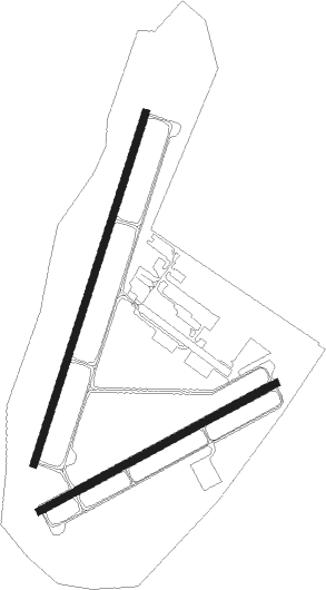
Runway info
Runway 4 / 22  | ||
| length | 1528m (5013ft) | |
| bearing | 29° / 209° | |
| width | 30m (100ft) | |
| surface | asphalt | |
| blast zone | 46m (151ft) / 45m (148ft) | |
| Runway 8 / 26 | ||
| length | 1116m (3661ft) | |
| bearing | 72° / 252° | |
| width | 30m (100ft) | |
| surface | asphalt | |
| displ threshold | 0m (0ft) / 95m (312ft) | |
| blast zone | 45m (148ft) / 75m (246ft) | |
Nearby beacons
| code | identifier | dist | bearing | frequency |
|---|---|---|---|---|
| SW | NEELY (NEWBURGH) NDB | 2.1 | 123° | 335 |
| SKU | STANWYCK (NEWBURGH) NDB | 9.9 | 85° | 261 |
| HUO | HUGUENOT VOR/DME | 15.9 | 253° | 116.10 |
| IGN | KINGSTON VOR/DME | 21.9 | 71° | 117.60 |
| SAX | SPARTA VORTAC | 29.3 | 212° | 115.70 |
| PWL | PAWLING (POUGHKEEPSIE) VOR/DME | 33.6 | 69° | 114.30 |
| CMK | CARMEL VOR/DME | 33.7 | 109° | 116.60 |
| MM | MOREE (MORRISTOWN) NDB | 37.9 | 186° | 392 |
| TEB | TETERBORO VOR/DME | 40.7 | 163° | 108.40 |
| STW | STILLWATER VOR/DME | 41.2 | 230° | 109.60 |
| TE | TORBY (TETERBORO) NDB | 42.7 | 169° | 214 |
| CAT | CHATHAM NDB | 46.7 | 192° | 254 |
| LGA | LA GUARDIA (NEW YORK) VOR/DME | 47.1 | 151° | 113.10 |
| BWZ | BROADWAY (SCHOOLEY'S MT) VOR/DME | 49.6 | 218° | 114.20 |
| DNY | DE LANCEY VOR/DME | 50.6 | 314° | 112.10 |
| PFH | PHILMONT (HUDSON) NDB | 50.7 | 36° | 272 |
| CRI | CANARSIE VOR/DME | 56.4 | 158° | 112.30 |
| FR | FRIKK (FARMINGDALE) NDB | 56.4 | 133° | 407 |
| JFK | KENNEDY (NEW YORK) VOR/DME | 57.2 | 151° | 115.90 |
| SBJ | SOLBERG VOR/DME | 59.7 | 207° | 112.90 |
| DPK | DEER PARK VOR/DME | 61.2 | 127° | 117.70 |
| RKA | ROCKDALE VOR/DME | 72 | 314° | 112.60 |
Instrument approach procedures
| runway | airway (heading) | route (dist, bearing) |
|---|---|---|
| RW04 | HAAYS (47°) | HAAYS SEDLE (5mi, 76°) 3000ft |
| RW04 | SAX (32°) | SAX SEDLE (19mi, 33°) 3000ft |
| RW04 | SEDLE (29°) | SEDLE 6000ft SEDLE (turn) 3000ft |
| RNAV | SEDLE 3000ft STUFF (6mi, 28°) 1800ft KMGJ (5mi, 30°) 407ft (4701mi, 119°) 770ft WERKA (4701mi, 299°) HELON (6mi, 327°) 5300ft HELON (turn) 5300ft | |
| RW08 | HUO (73°) | HUO OSSEK (5mi, 78°) 2900ft |
| RNAV | OSSEK 2900ft WEJTI (6mi, 72°) 2000ft KMGJ (5mi, 70°) 392ft (4701mi, 119°) 770ft YORNO (4697mi, 299°) HELON (9mi, 318°) 5300ft HELON (turn) 5300ft | |
| RW22 | PRNCE (156°) | PRNCE NUDUE (10mi, 128°) 5300ft ZUMRI (10mi, 128°) 3500ft |
| RW22 | TRESA (230°) | TRESA ZUMRI (18mi, 245°) 3500ft |
| RNAV | ZUMRI 3500ft DATRR (6mi, 209°) 2700ft KMGJ (8mi, 208°) 422ft (4701mi, 119°) 1500ft HELON (4704mi, 299°) 5300ft HELON (turn) 5300ft | |
| RW26 | BASYE (290°) | BASYE GETRE (13mi, 308°) 4000ft BUNRE (5mi, 330°) 3000ft |
| RW26 | BUNRE (252°) | BUNRE 6000ft BUNRE (turn) 3000ft |
| RW26 | SPECL (226°) | SPECL BUNRE (6mi, 147°) 3000ft |
| RNAV | BUNRE 3000ft EXEBE (4mi, 252°) 2000ft ORNGE (2mi, 252°) 1800ft KMGJ (5mi, 253°) 411ft (4701mi, 119°) 770ft WEJTI (4706mi, 299°) UTULE (8mi, 330°) HELON (8mi, 66°) 4000ft HELON (turn) |
Disclaimer
The information on this website is not for real aviation. Use this data with the X-Plane flight simulator only! Data taken with kind consent from X-Plane 12 source code and data files. Content is subject to change without notice.