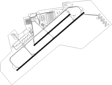
Sacramento - Sacramento Mather
Airport details
| Country | United States of America |
| State | California |
| Region | K2 |
| Airspace | Oakland Ctr |
| Municipality | Sacramento County |
| Elevation | 98ft (30m) |
| Timezone | GMT -8 |
| Coordinates | 38.55623, -121.28554 |
| Magnetic var | |
| Type | land |
| Available since | X-Plane v10.40 |
| ICAO code | KMHR |
| IATA code | MHR |
| FAA code | MHR |
Communication
| Sacramento Mather ATIS | 118.325 |
| Sacramento Mather CTAF | 120.650 |
| Sacramento Mather UNICOM | 123.075 |
| Sacramento Mather Ground Control | 121.850 |
| Sacramento Mather Tower | 120.650 |
| Sacramento Mather NORCAL Approach/Departure | 127.400 |
Approach frequencies
| ILS-cat-I | RW22L | 111.35 | 18.00mi |
| 3° GS | RW22L | 111.35 | 18.00mi |
Nearby Points of Interest:
Brighton School
-American River Grange Hall No. 172
-SMUD Headquarters Building
-Dunlap's Dining Room
-Chung Wah Cemetery
-Julia Morgan House
-Libby, McNeil and Libby Cannery
-Fire Station No. 6
-Old Tavern (Sacramento, California)
-Eastern Star Hall
-Folsom Depot
-Winters House
-J. C. Carly House
-Cohn House
-Cranston-Geary House
-Firehouse No. 3
-Calpak Plant No. 11
-Sacramento Masonic Temple
-J. Neely Johnson House
-California State Capitol
-Sacramento City Library
-Federal Building
-Blue Anchor Building
-Coolot Company Building
-Mesick House
Nearby beacons
| code | identifier | dist | bearing | frequency |
|---|---|---|---|---|
| MCC | MC CLELLAN (SACRAMENTO) VOR/DME | 8.6 | 313° | 109.20 |
| SAC | SACRAMENTO VORTAC | 14.2 | 247° | 115.20 |
| HNW | HANGTOWN (PLACERVILLE) VOR/DME | 27.1 | 73° | 115.50 |
| LIN | LINDEN VOR/DME | 31.8 | 150° | 114.80 |
| MYV | MARYSVILLE VOR/DME | 35.2 | 332° | 110.80 |
| BAB | BEALE (MARYSVILLE) TACAN | 35.4 | 345° | 108.60 |
| SUU | TRAVIS (FAIRFIELD) TACAN | 36.2 | 245° | 116.60 |
| ILA | WILLIAMS VORTAC | 46.4 | 305° | 114.40 |
| CCR | CONCORD VOR/DME | 47.1 | 236° | 117 |
| LV | REIGA (LIVERMORE) NDB | 55.2 | 205° | 374 |
| MOD | MODESTO VOR/DME | 57.8 | 161° | 114.60 |
| OAK | OAKLAND VOR/DME | 66.7 | 228° | 116.80 |
Departure and arrival routes
| Transition altitude | 18000ft |
| Transition level | 18000ft |
| STAR starting points | distance | inbound heading | |
|---|---|---|---|
| ALL | |||
| AMRVR2 | 53.0 | 258° | |
Instrument approach procedures
| runway | airway (heading) | route (dist, bearing) |
|---|---|---|
| RW04R | GALTS (2°) | GALTS LOGYE (14mi, 312°) 2000ft LOGYE (turn) 2000ft |
| RW04R | PIVSE (76°) | PIVSE SAC (7mi, 93°) 3000ft LOGYE (3mi, 89°) 2000ft |
| RNAV | LOGYE 2000ft ZISES (6mi, 60°) 1400ft KMHR (5mi, 62°) 127ft (6844mi, 108°) 331ft STNGR (6832mi, 288°) 3300ft STNGR (turn) | |
| RW22L | HAGAN (208°) | HAGAN STNGR (12mi, 168°) 4300ft STNGR (turn) 3500ft |
| RW22L | HNW (253°) | HNW STNGR (15mi, 263°) 5200ft STNGR (turn) 3500ft |
| RNAV | STNGR 3500ft JASOD (3mi, 240°) 2600ft GADBE (4mi, 240°) 1800ft JEKAX (3mi, 240°) 800ft KMHR (2mi, 235°) 154ft (6844mi, 108°) 298ft XAKBE (6850mi, 288°) SAC (8mi, 251°) 3000ft SAC (turn) | |
| RW22R | HAGAN (208°) | HAGAN BUZEF (12mi, 170°) 4000ft |
| RW22R | HNW (253°) | HNW BUZEF (15mi, 264°) 6000ft BUZEF (turn) 4000ft |
| RNAV | BUZEF 4000ft FIBAG (4mi, 240°) 2600ft GRDEN (4mi, 240°) 1800ft NUMBY (3mi, 240°) 900ft KMHR (3mi, 232°) 139ft (6844mi, 108°) 500ft SAC (6858mi, 288°) 3000ft SAC (turn) |
Disclaimer
The information on this website is not for real aviation. Use this data with the X-Plane flight simulator only! Data taken with kind consent from X-Plane 12 source code and data files. Content is subject to change without notice.

