Manchester
Airport details
| Country | United States of America |
| State | New Hampshire |
| Region | K6 |
| Airspace | Boston Ctr |
| Municipality | Manchester |
| Elevation | 241ft (73m) |
| Timezone | GMT -5 |
| Coordinates | 42.93280, -71.43575 |
| Magnetic var | |
| Type | land |
| Available since | X-Plane v10.40 |
| ICAO code | KMHT |
| IATA code | MHT |
| FAA code | MHT |
Communication
| Manchester KMHT ATIS | 119.550 |
| Manchester MANCHESTER UNIC | 122.950 |
| Manchester MANCHESTER CLD | 135.900 |
| Manchester MANCHESTER Ground Control | 121.900 |
| Manchester MANCHESTER Tower | 121.300 |
| Manchester MANCHESTER Approach | 124.900 |
| Manchester MANCHESTER Departure | 124.900 |
Approach frequencies
| ILS-cat-III | RW35 | 109.1 | 18.00mi |
| ILS-cat-I | RW06 | 109.95 | 18.00mi |
| ILS-cat-I | RW17 | 109.1 | 18.00mi |
| 3.1° GS | RW17 | 109.1 | 18.00mi |
| 3° GS | RW35 | 109.1 | 18.00mi |
| 3° GS | RW06 | 109.95 | 18.00mi |
Nearby Points of Interest:
Hoyt Shoe Factory
-Kimball Brothers Shoe Factory
-T. L. Thorpe Building
-District A
-New Hampshire State Union Armory
-Hill-Lassonde House
-Bedford Town Hall
-Old Post Office Block
-Harrington-Smith Block
-District B
-City Hall
-Dunlap Building
-Ash Street School
-District C
-Thomas Russell Hubbard House
-Alpheus Gay House
-America's Credit Union Museum
-Roger Sullivan House
-District E
-Weston Observatory
-Carpenter and Bean Block
-District D
-Frank Pierce Carpenter House
-William Parker Straw House
-Gen. John Stark House
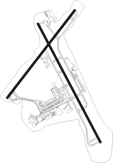
Runway info
Runway 17 / 35  | ||
| length | 2822m (9259ft) | |
| bearing | 149° / 329° | |
| width | 46m (150ft) | |
| surface | asphalt | |
| displ threshold | 102m (335ft) / 259m (850ft) | |
| blast zone | 4m (13ft) / 4m (13ft) | |
| Runway 6 / 24 | ||
| length | 2331m (7648ft) | |
| bearing | 51° / 231° | |
| width | 46m (151ft) | |
| surface | asphalt | |
| displ threshold | 135m (443ft) / 0m (0ft) | |
| blast zone | 4m (13ft) / 4m (13ft) | |
Nearby beacons
| code | identifier | dist | bearing | frequency |
|---|---|---|---|---|
| MHT | MANCHESTER VOR/DME | 4.8 | 134° | 114.40 |
| MJ | FITZY (MANCHESTER) NDB | 5.8 | 234° | 209 |
| CO | EPSOM (CONCORD) NDB | 11.1 | 355° | 216 |
| CON | CONCORD VOR/DME | 18.2 | 334° | 112.90 |
| LWM | DME | 18.9 | 119° | 112.50 |
| PSM | (PORTSMOUTH) DME | 28 | 76° | 116.50 |
| ESG | ROLLINS (ROLLINSFORD) NDB | 31.7 | 65° | 260 |
| SF | SANFD (SANFORD) NDB | 35.7 | 56° | 349 |
| GDM | GARDNER VOR/DME | 35.9 | 238° | 110.60 |
| LC | BLNAP (LACONIA) NDB | 36.5 | 350° | 328 |
| EEN | DME | 38.5 | 261° | 109.40 |
| BOS | BOSTON VOR/DME | 39.7 | 142° | 112.70 |
| ENE | KENNEBUNK VOR/DME | 46.6 | 59° | 117.10 |
| CNH | CLAREMONT NDB | 48.6 | 295° | 233 |
| OW | STOGE (NORWOOD) NDB | 50.6 | 159° | 397 |
| LEB | DME | 56.3 | 314° | 113.70 |
| LAH | HANOVER (LEBANON) NDB | 56.4 | 316° | 276 |
| PUT | PUTNAM VOR/DME | 61.4 | 203° | 117.40 |
Departure and arrival routes
| Transition altitude | 18000ft |
| Transition level | 18000ft |
| SID end points | distance | outbound heading | |
|---|---|---|---|
| RW06 | |||
| MHT1 | 42mi | 198° | |
| PPORT4 | 81mi | 232° | |
| RW17 | |||
| MHT1 | 42mi | 198° | |
| PPORT4 | 81mi | 232° | |
| RW24 | |||
| MHT1 | 42mi | 198° | |
| PPORT4 | 81mi | 232° | |
| RW35 | |||
| MHT1 | 42mi | 198° | |
| PPORT4 | 81mi | 232° | |
| STAR starting points | distance | inbound heading | |
|---|---|---|---|
| RW06 | |||
| ROZZE2 | 25.2 | 79° | |
| RW17 | |||
| ROZZE2 | 25.2 | 79° | |
| RW24 | |||
| ROZZE2 | 25.2 | 79° | |
| RW35 | |||
| ROZZE2 | 25.2 | 79° | |
Instrument approach procedures
| runway | airway (heading) | route (dist, bearing) |
|---|---|---|
| RW06 | FOSAN (77°) | FOSAN HEDGI (7mi, 124°) 3000ft |
| RW06 | HAKAM (19°) | HAKAM HEDGI (7mi, 304°) 3000ft |
| RW06 | HEDGI (52°) | HEDGI 3000ft |
| RNAV | HEDGI 3000ft CUTSA (6mi, 51°) 2000ft KMHT (6mi, 53°) 271ft (4596mi, 121°) 474ft CUXOV (4593mi, 301°) KHRIS (5mi, 117°) 3000ft KHRIS (turn) 3000ft | |
| RW17-Y | CON (154°) | CON BLUUM (11mi, 157°) 2500ft |
| RW17-Y | PURBL (97°) | PURBL 5000ft LYLAC (6mi, 10°) 3000ft BLSSM (4mi, 79°) 3000ft BLUUM (3mi, 116°) 2500ft |
| RNAV | BLUUM 2500ft ORDIE (3mi, 149°) 1600ft KMHT (5mi, 150°) 267ft (4596mi, 121°) 429ft YOULL (4591mi, 301°) 2000ft YOULL (turn) | |
| RW17-Z | GRNAT (150°) | GRNAT BLUUM (2mi, 149°) 2500ft ORDIE (3mi, 149°) 1600ft |
| RW17-Z | PURBL (97°) | PURBL 5000ft LLIVE (3mi, 64°) 4000ft FREEH (3mi, 64°) 3000ft ORDIE (4mi, 102°) 1600ft |
| RNAV | ORDIE 1600ft KMHT (5mi, 150°) 267ft YOULL (8mi, 149°) 2100ft YOULL (turn) | |
| RW24 | FABIG (254°) | FABIG WAVBO (6mi, 304°) 2900ft |
| RW24 | PUTRE (198°) | PUTRE WAVBO (6mi, 124°) 2900ft |
| RW24 | WAVBO (230°) | WAVBO 2900ft |
| RNAV | WAVBO 2900ft ONGEE (6mi, 231°) 1800ft KMHT (5mi, 229°) 292ft (4596mi, 121°) 666ft CON (4605mi, 301°) 5000ft CON (turn) 5000ft | |
| RW35-Y | PELAN (329°) | PELAN YOULL (4mi, 330°) 2500ft |
| RW35-Y | SHOWZ (49°) | SHOWZ 5000ft IHOBB (6mi, 129°) 3000ft ELEEE (5mi, 76°) 3000ft YOULL (3mi, 10°) 2500ft |
| RNAV | YOULL 2500ft MNTIN (3mi, 329°) 1600ft XOHWI (2mi, 329°) 920ft KMHT (3mi, 328°) 320ft (4596mi, 121°) 465ft BLUUM (4600mi, 301°) 3000ft BLUUM (turn) | |
| RW35-Z | PELAN (329°) | PELAN YOULL (4mi, 330°) 2500ft MNTIN (3mi, 329°) 1600ft |
| RW35-Z | SHOWZ (49°) | SHOWZ 5000ft OLDMN (3mi, 92°) 4000ft OFTHE (3mi, 92°) 3000ft MNTIN (4mi, 43°) 1600ft |
| RNAV | MNTIN 1600ft KMHT (5mi, 329°) 320ft BLUUM (8mi, 330°) 3000ft BLUUM (turn) |
Disclaimer
The information on this website is not for real aviation. Use this data with the X-Plane flight simulator only! Data taken with kind consent from X-Plane 12 source code and data files. Content is subject to change without notice.