Muncie - Delaware Co Johnson Field
Airport details
| Country | United States of America |
| State | Indiana |
| Region | K5 |
| Airspace | Indianapolis Ctr |
| Municipality | Delaware County |
| Elevation | 937ft (286m) |
| Timezone | GMT -5 |
| Coordinates | 40.24247, -85.39575 |
| Magnetic var | |
| Type | land |
| Available since | X-Plane v10.40 |
| ICAO code | KMIE |
| IATA code | MIE |
| FAA code | MIE |
Communication
| Delaware Co Johnson Field ATIS | 133.250 |
| Delaware Co Johnson Field CTAF | 120.100 |
| Delaware Co Johnson Field UNICOM | 122.950 |
| Delaware Co Johnson Field MUNCIE Ground Control | 121.900 |
| Delaware Co Johnson Field MUNCIE Tower | 120.100 |
Approach frequencies
| ILS-cat-I | RW32 | 109.1 | 18.00mi |
| 3° GS | RW32 | 109.1 | 18.00mi |
Nearby Points of Interest:
Wysor Heights Historic District
-Minnetrista Boulevard Historic District
-Westwood Historic District
-John Valentine House
-Hamilton Township Schoolhouse No. 4
-Alva Kitselman House
-Riverside Historic District
-Cincinnati, Richmond, & Muncie Depot
-Meeks Avenue Historic District
-Goldsmith C. Gilbert Historic District
-Moore-Youse-Maxon House
-Judson Building
-J.C. Johnson House
-Boyce Block
-Masonic Temple
-City Hall
-Old West End Historic District
-W.W. Shirk Building
-Carnegie Library
-Walnut Street Historic District
-Otto Carmichael House
-Emily Kimbrough Historic District
-Francis T. Roots Building
-F.D. Rose Building
-Margaret and George Riley Jones House
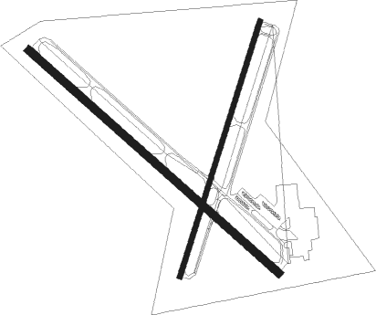
Runway info
Runway 14 / 32  | ||
| length | 1983m (6506ft) | |
| bearing | 129° / 309° | |
| width | 46m (150ft) | |
| surface | asphalt | |
| blast zone | 0m (0ft) / 61m (200ft) | |
| Runway 3 / 21 | ||
| length | 1586m (5203ft) | |
| bearing | 28° / 208° | |
| width | 30m (100ft) | |
| surface | asphalt | |
| blast zone | 0m (0ft) / 61m (200ft) | |
Nearby beacons
| code | identifier | dist | bearing | frequency |
|---|---|---|---|---|
| MIE | MUNCIE VOR/DME | 0.3 | 162° | 114.40 |
| JN | BALLL (MUNCIE) NDB | 5 | 129° | 365 |
| MI | BALLL (MUNCIE) NDB | 5 | 129° | 365 |
| AI | VIDEO (ANDERSON) NDB | 11.6 | 214° | 394 |
| MZZ | MARION VOR/DME | 19.8 | 312° | 108.60 |
| UWL | NEW CASTLE NDB | 22 | 168° | 385 |
| AWW | WINCHESTER NDB | 22.1 | 99° | 212 |
| SQ | PNTHR (CONNERSVILLE) NDB | 30.5 | 150° | 227 |
| OKK | KOKOMO VORTAC | 34.8 | 293° | 113.50 |
| UMP | METROPOLITAN (INDIANAPOLIS) NDB | 35.2 | 245° | 338 |
| RID | RICHMOND VOR/DME | 38.9 | 131° | 110.60 |
| SHB | SHELBYVILLE VOR/DME | 41.6 | 215° | 112 |
| GUS | GRISSOM (PERU) VORTAC | 42.1 | 298° | 108.45 |
| FWA | FORT WAYNE VORTAC | 45.2 | 16° | 117.80 |
| FV | LAREZ (INDIANAPOLIS) NDB | 45.8 | 240° | 349 |
| DQN | DAYTON VOR/DME | 47.8 | 103° | 114.50 |
| CO | COLFA (INDIANAPOLIS) NDB | 50.5 | 233° | 232 |
| VHP | BRICKYARD VORTAC | 51.5 | 246° | 116.30 |
| HLB | BATESVILLE NDB | 54.1 | 171° | 254 |
| BA | CLIFS (COLUMBUS) NDB | 58.6 | 205° | 410 |
| HKF | HOOK FIELD (MIDDLETOWN) NDB | 62.4 | 128° | 239 |
Instrument approach procedures
| runway | airway (heading) | route (dist, bearing) |
|---|---|---|
| RW03 | APPAL (27°) | APPAL 2800ft |
| RNAV | APPAL 2800ft CESUD (8mi, 28°) 2600ft HABIP (3mi, 28°) 1640ft KMIE (2mi, 25°) 976ft (5194mi, 115°) 1190ft IFECA (5190mi, 295°) 2800ft IFECA (turn) | |
| RW14 | MIE (342°) | MIE JOGBA (12mi, 309°) 2800ft JOGBA (turn) 2800ft |
| RW14 | MZZ (132°) | MZZ JOGBA (9mi, 136°) 2800ft |
| RNAV | JOGBA 2800ft HIXAG (6mi, 128°) 2500ft KMIE (5mi, 128°) 979ft (5194mi, 115°) 1202ft CITUK (5186mi, 295°) 2900ft CITUK (turn) | |
| RW21 | MIE (342°) | MIE IFECA (13mi, 27°) 2800ft IFECA (turn) 2800ft |
| RW21 | NOMPE (169°) | NOMPE IFECA (7mi, 107°) 2800ft |
| RW21 | UHZAW (240°) | UHZAW IFECA (7mi, 287°) 2800ft |
| RNAV | IFECA 2800ft CIKEP (7mi, 208°) 2600ft KMIE (6mi, 209°) 980ft (5194mi, 115°) 1195ft APPAL (5198mi, 295°) 2800ft APPAL (turn) | |
| RW32 | MIE (342°) | MIE CITUK (11mi, 128°) 2900ft CITUK (turn) 2900ft |
| RW32 | WAMBO (311°) | WAMBO CITUK (3mi, 320°) 2900ft |
| RNAV | CITUK 2900ft PEYIV (6mi, 309°) 2600ft KMIE (5mi, 309°) 988ft (5194mi, 115°) 1241ft JOGBA (5202mi, 295°) 2800ft JOGBA (turn) |
Disclaimer
The information on this website is not for real aviation. Use this data with the X-Plane flight simulator only! Data taken with kind consent from X-Plane 12 source code and data files. Content is subject to change without notice.