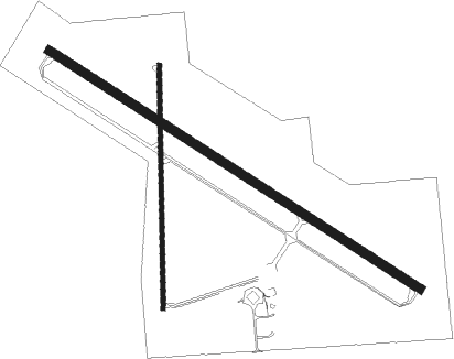
Marshalltown - Marshalltown Muni
Airport details
| Country | United States of America |
| State | Iowa |
| Region | K3 |
| Airspace | Chicago Ctr |
| Municipality | Marshall County |
| Elevation | 974ft (297m) |
| Timezone | GMT -6 |
| Coordinates | 42.11273, -92.91778 |
| Magnetic var | |
| Type | land |
| Available since | X-Plane v10.40 |
| ICAO code | KMIW |
| IATA code | n/a |
| FAA code | MIW |
Communication
| Marshalltown Muni ASOS | 128.325 |
| Marshalltown Muni CTAF/UNICOM | 122.800 |
| Marshalltown Muni WATERLOO Approach/Departure | 120.900 |
Nearby Points of Interest:
Thaddeus Binford House
-Glick-Sower House
-First Church of Christ, Scientist
-Marshalltown Downtown Historic District
-Leroy R. Willard House
-Marshall County Courthouse
-Robert H. Sunday House
-Watson's Grocery
-Dobbin Round Barn
-New Providence School Gymnasium
-Grundy County Courthouse
-Tama County Jail
-Tama County Courthouse
-Civilian Conservation Corps-Prisoner of War Recreation Hall
-Hardin County Courthouse
-Former Eldora Public Library
-Lincoln Highway Bridge
-Steamboat Rock Consolidated Schools Building
-Folkert Mound Group
-Star-Clipper-Canfield Building and Winding Stairway
-Round Barn, Buckingham Township
-B.J. Ricker House
-Christian Science Society
-Goodnow Hall
-Mears Cottage
Nearby beacons
| code | identifier | dist | bearing | frequency |
|---|---|---|---|---|
| JWJ | ELMWOOD (MARSHALTOWN) VOR/DME | 0.4 | 99° | 109.40 |
| TNU | NEWTON VOR/DME | 21.5 | 210° | 112.50 |
| ALO | WATERLOO VOR/DME | 35.2 | 49° | 112.20 |
| PEA | PELLA NDB | 42.5 | 182° | 257 |
| IIB | WAPSIE (INDEPENDENCE) NDB | 47.6 | 71° | 206 |
| DSM | DES MOINES VORTAC | 52.1 | 227° | 117.50 |
| MC | SURFF (MASON CITY) NDB | 59.2 | 336° | 348 |
| MCW | MASON CITY VOR/DME | 61.7 | 337° | 114.90 |
Instrument approach procedures
| runway | airway (heading) | route (dist, bearing) |
|---|---|---|
| RW13 | BRIDY (119°) | BRIDY 6000ft BRIDY (turn) 2700ft |
| RNAV | BRIDY 2700ft ATAXE (6mi, 119°) 2600ft IKUDY (3mi, 119°) 1620ft KMIW (2mi, 120°) 1016ft (5535mi, 114°) 1225ft VUNDY (5526mi, 294°) 2600ft VUNDY (turn) | |
| RW31 | VUNDY (299°) | VUNDY 6000ft VUNDY (turn) 2600ft |
| RNAV | VUNDY 2600ft BEKFY (6mi, 299°) 2600ft JIPTI (3mi, 299°) 1740ft KMIW (3mi, 299°) 1009ft (5535mi, 114°) 1223ft BRIDY (5544mi, 294°) 2700ft BRIDY (turn) |
Disclaimer
The information on this website is not for real aviation. Use this data with the X-Plane flight simulator only! Data taken with kind consent from X-Plane 12 source code and data files. Content is subject to change without notice.

