Muskogee - Davis Field
Airport details
| Country | United States of America |
| State | Oklahoma |
| Region | K4 |
| Airspace | Ft Worth Ctr |
| Municipality | Muskogee |
| Elevation | 610ft (186m) |
| Timezone | GMT -6 |
| Coordinates | 35.65775, -95.36164 |
| Magnetic var | |
| Type | land |
| Available since | X-Plane v10.40 |
| ICAO code | KMKO |
| IATA code | MKO |
| FAA code | MKO |
Communication
| Davis Field ASOS | 135.025 |
| Davis Field CTAF/UNICOM | 122.800 |
Nearby Points of Interest:
St. Thomas Primitive Baptist Church
-Severs Hotel
-Surety Building
-Manhattan Building
-Railway Exchange Building
-Ed Edmondson United States Courthouse
-First Baptist Church
-Central Baptist Church
-V. R. Coss House
-A.W. Patterson House
-A. C. Trumbo House
-Ward Chapel AME Church
-Grant Foreman House
-Commandant's Quarters
-Oklahoma Odd Fellows Home at Checotah
-First United Methodist Church
-Collin McKinney House
-John W. Gibson House
-Wagoner Armory
-Cobb Building
-Frederick Parkinson House
-First Presbyterian Church
-Cherokee National Jail
-American Legion Hut
-Eastside Baptist Church
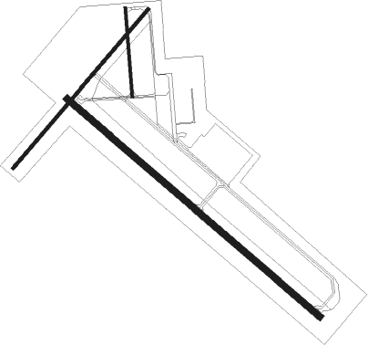
Runway info
Runway 13 / 31  | ||
| length | 2196m (7205ft) | |
| bearing | 129° / 309° | |
| width | 46m (150ft) | |
| surface | asphalt | |
| blast zone | 50m (164ft) / 43m (141ft) | |
| Runway 4 / 22 | ||
| length | 1371m (4498ft) | |
| bearing | 51° / 231° | |
| width | 23m (75ft) | |
| surface | asphalt | |
| Runway 18 / 36 | ||
| length | 582m (1909ft) | |
| bearing | 180° / 0° | |
| width | 18m (60ft) | |
| surface | asphalt | |
Nearby beacons
| code | identifier | dist | bearing | frequency |
|---|---|---|---|---|
| OKM | OKMULGEE VOR/DME | 24.6 | 274° | 114.90 |
| OK | PRESO (OKMULGEE) NDB | 29.2 | 279° | 388 |
| GNP | (TULSA) DME | 33.5 | 293° | 110.60 |
| HET | HENRYETTA NDB | 35.3 | 249° | 267 |
| TU | OILLR (TULSA) NDB | 36.8 | 310° | 338 |
| TUL | TULSA VORTAC | 38.4 | 322° | 114.40 |
| MLC | MCALESTER TACAN | 52.7 | 207° | 112 |
| SLG | SILOAM SPRINGS NDB | 53.1 | 59° | 284 |
| PGO | RICH MOUNTAIN (PAGE) VORTAC | 69.3 | 142° | 113.50 |
Instrument approach procedures
| runway | airway (heading) | route (dist, bearing) |
|---|---|---|
| RW04 | LADME (27°) | LADME MEKLE (5mi, 309°) 2400ft |
| RW04 | MEKLE (52°) | MEKLE 2400ft |
| RW04 | NADOE (74°) | NADOE MEKLE (5mi, 129°) 2400ft |
| RNAV | MEKLE 2400ft OHAGU (6mi, 51°) 2200ft KMKO (5mi, 54°) 651ft (5667mi, 111°) 1012ft CERKA (5658mi, 291°) 2600ft CERKA (turn) | |
| RW13 | JANUX (158°) | JANUX 2900ft POKYO (6mi, 231°) 2900ft |
| RW13 | MODVE (105°) | MODVE 2900ft POKYO (6mi, 51°) 2900ft |
| RW13 | POKYO (129°) | POKYO 2900ft |
| RNAV | POKYO 2900ft CULAD (6mi, 129°) 2400ft HENBI (2mi, 129°) 1620ft KMKO (3mi, 128°) 657ft FALUN (12mi, 130°) 2800ft FALUN (turn) | |
| RW22 | CERKA (229°) | CERKA 2600ft |
| RW22 | JOKAT (204°) | JOKAT 2600ft CERKA (5mi, 129°) 2600ft |
| RW22 | KURRE (251°) | KURRE 2600ft CERKA (5mi, 309°) 2600ft |
| RNAV | CERKA 2600ft FEVUP (6mi, 231°) 2200ft KMKO (5mi, 227°) 636ft MEKLE (11mi, 232°) 2400ft MEKLE (turn) | |
| RW31 | EKARE (286°) | EKARE 2800ft FALUN (6mi, 231°) 2800ft |
| RW31 | FALUN (310°) | FALUN 2800ft |
| RW31 | GAMRE (337°) | GAMRE 3700ft FALUN (6mi, 51°) 2800ft |
| RNAV | FALUN 2800ft IVCUP (6mi, 309°) 2400ft CONIK (3mi, 309°) 1540ft KMKO (4mi, 310°) 634ft POKYO (12mi, 309°) 2900ft POKYO (turn) |
Disclaimer
The information on this website is not for real aviation. Use this data with the X-Plane flight simulator only! Data taken with kind consent from X-Plane 12 source code and data files. Content is subject to change without notice.