Melbourne - Orlando Melbourne Intl
Airport details
| Country | United States of America |
| State | Florida |
| Region | K7 |
| Airspace | Miami Oceanic Ctr |
| Municipality | Melbourne |
| Elevation | 40ft (12m) |
| Timezone | GMT -5 |
| Coordinates | 28.10275, -80.64526 |
| Magnetic var | |
| Type | land |
| Available since | X-Plane v10.40 |
| ICAO code | KMLB |
| IATA code | MLB |
| FAA code | MLB |
Communication
| Orlando Melbourne Intl ATIS | 132.550 |
| Orlando Melbourne Intl UNICOM | 122.950 |
| Orlando Melbourne Intl CTAF | 118.200 |
| Orlando Melbourne Intl Clearance DEL | 132.650 |
| Orlando Melbourne Intl Ground Control | 121.900 |
| Orlando Melbourne Intl Tower | 118.200 |
| Orlando Melbourne Intl ORLANDO Approach/Departure | 132.250 |
Approach frequencies
| ILS-cat-I | RW09R | 108.3 | 18.00mi |
| 2.8° GS | RW09R | 108.3 | 18.00mi |
Nearby Points of Interest:
James Wadsworth Rossetter House
-William H. Gleason House
-Florida Power and Light Company Ice Plant
-Community Chapel of Melbourne Beach
-Persimmon Mound
-Jorgensen's General Store
-Marion S. Whaley Citrus Packing House
-Rockledge Drive Residential District
-Barton Avenue Residential District
-Valencia Subdivision Residential District
-Aladdin Theater
-Porcher House
-Dr. George E. Hill House
-J. R. Field Homestead
-Archie Smith Wholesale Fish Company
-Old Town Sebastian Historic District, West
-Old Town Sebastian Historic District, East
-Bamma Vickers Lawson House
-Marian Fell Library
-City Point Community Church
-First Methodist Episcopal Church
-Pelican Island National Wildlife Refuge
-St. Luke's Episcopal Church and Cemetery
-Cape Canaveral Space Force Station
-Operations and Checkout Building
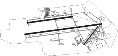
Runway info
Runway 9R / 27L  | ||
| length | 3098m (10164ft) | |
| bearing | 87° / 267° | |
| width | 46m (150ft) | |
| surface | asphalt | |
| displ threshold | 0m (0ft) / 213m (699ft) | |
| blast zone | 122m (400ft) / 122m (400ft) | |
| Runway 9L / 27R | ||
| length | 1822m (5978ft) | |
| bearing | 87° / 267° | |
| width | 46m (150ft) | |
| surface | asphalt | |
| Runway 5 / 23 | ||
| length | 916m (3005ft) | |
| bearing | 46° / 226° | |
| width | 23m (75ft) | |
| surface | asphalt | |
Nearby beacons
| code | identifier | dist | bearing | frequency |
|---|---|---|---|---|
| MLB | MELBOURNE VOR/DME | 0.5 | 76° | 115.85 |
| COF | PATRICK (COCOA) TACAN | 8.2 | 14° | 115 |
| TRV | TREASURE (VERO BEACH) VORTAC | 26.7 | 160° | 117.30 |
| FPR | FORT PIERCE NDB | 39.7 | 156° | 275 |
| ORL | ORLANDO VORTAC | 45 | 303° | 112.20 |
| OR | HERNY (ORLANDO) NDB | 48.2 | 297° | 221 |
Departure and arrival routes
| Transition altitude | 18000ft |
| Transition level | 18000ft |
| STAR starting points | distance | inbound heading | |
|---|---|---|---|
| ALL | |||
| JOKRS2 | 57.2 | 86° | |
| PRICY1 | 70.0 | 88° | |
| BITHO7 | 76.1 | 159° | |
Instrument approach procedures
| runway | airway (heading) | route (dist, bearing) |
|---|---|---|
| RW09L | CEJNO (88°) | CEJNO 2000ft |
| RW09L | PRESK (115°) | PRESK SUZEN (10mi, 121°) 3000ft FIFMU (7mi, 121°) 2000ft CEJNO (5mi, 171°) 2000ft |
| RW09L | TRV (340°) | TRV NAJBE (28mi, 311°) 2000ft CEJNO (5mi, 3°) 2000ft |
| RNAV | CEJNO 2000ft AWZAC (6mi, 87°) 1600ft KMLB (6mi, 89°) 86ft (4910mi, 109°) 281ft LIQNI (4900mi, 289°) 2000ft LIQNI (turn) | |
| RW09R | PRESK (115°) | PRESK SUZEN (10mi, 121°) 3000ft FIFMU (7mi, 121°) 2000ft SUROY (5mi, 172°) 2000ft |
| RW09R | SUROY (87°) | SUROY 2000ft |
| RW09R | TRV (340°) | TRV NAJBE (28mi, 311°) 2000ft SUROY (5mi, 2°) 2000ft |
| RNAV | SUROY 2000ft JINBA (6mi, 87°) 1600ft KMLB (6mi, 87°) 87ft (4910mi, 109°) 232ft ZUVOM (4899mi, 289°) 2000ft ZUVOM (turn) | |
| RW27L | INDIA (160°) | INDIA IGMIF (23mi, 125°) 2000ft ZUVOM (5mi, 182°) 2000ft |
| RW27L | TRV (340°) | TRV OPTOZ (21mi, 11°) 2000ft ZUVOM (5mi, 351°) 2000ft |
| RW27L | ZUVOM (267°) | ZUVOM 2000ft |
| RNAV | ZUVOM 2000ft JENOV (6mi, 267°) 1500ft KMLB (5mi, 268°) 74ft (4910mi, 109°) 222ft SUROY (4922mi, 289°) 2000ft SUROY (turn) | |
| RW27R | INDIA (160°) | INDIA IGMIF (23mi, 125°) 2000ft LIQNI (5mi, 189°) 2000ft |
| RW27R | LIQNI (266°) | LIQNI 2000ft |
| RW27R | TRV (340°) | TRV OPTOZ (21mi, 11°) 2000ft LIQNI (5mi, 345°) 2000ft |
| RNAV | LIQNI 2000ft HUKDI (6mi, 267°) 1500ft KMLB (5mi, 265°) 81ft (4910mi, 109°) 226ft CEJNO (4922mi, 289°) 2000ft CEJNO (turn) |
Holding patterns
| STAR name | hold at | type | turn | heading* | altitude | leg | speed limit |
|---|---|---|---|---|---|---|---|
| BITHO7 | LAMMA | VHF | left | 356 (176)° | < 17999ft | 1.0min timed | ICAO rules |
| BITHO7 | OMN | VHF | left | 2 (182)° | DME 10.0mi | ICAO rules | |
| JOKRS2 | FAZES | VHF | left | 169 (349)° | DME 10.0mi | ICAO rules | |
| JOKRS2 | MOANS | VHF | left | 183 (3)° | < 17999ft | 1.0min timed | ICAO rules |
| PRICY1 | CHIVE | VHF | right | 273 (93)° | DME 10.0mi | ICAO rules | |
| PRICY1 | DAAWG | VHF | right | 272 (92)° | DME 10.0mi | ICAO rules | |
| PRICY1 | DECKS | VHF | right | 276 (96)° | DME 10.0mi | ICAO rules | |
| PRICY1 | DOZES | VHF | right | 250 (70)° | DME 10.0mi | ICAO rules | |
| PRICY1 | PRICY | VHF | right | 252 (72)° | DME 10.0mi | ICAO rules | |
| *) magnetic outbound (inbound) holding course | |||||||
Disclaimer
The information on this website is not for real aviation. Use this data with the X-Plane flight simulator only! Data taken with kind consent from X-Plane 12 source code and data files. Content is subject to change without notice.