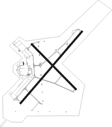
Monroe - Monroe Rgnl
Airport details
| Country | United States of America |
| State | Louisiana |
| Region | K4 |
| Airspace | Ft Worth Ctr |
| Municipality | Monroe |
| Elevation | 79ft (24m) |
| Timezone | GMT -6 |
| Coordinates | 32.51086, -92.03767 |
| Magnetic var | |
| Type | land |
| Available since | X-Plane v10.40 |
| ICAO code | KMLU |
| IATA code | MLU |
| FAA code | MLU |
Communication
| Monroe Rgnl ATIS | 125.050 |
| Monroe Rgnl UNICOM | 122.950 |
| Monroe Rgnl CTAF | 118.900 |
| Monroe Rgnl Clearance DEL | 121.650 |
| Monroe Rgnl MONROE GROUND | 121.900 |
| Monroe Rgnl MONROE TOWER | 118.900 |
| Monroe Rgnl MONROE Approach/Departure | 118.150 |
| Monroe Rgnl FT. WORTH Approach/Departure | 126.325 |
Approach frequencies
| ILS-cat-I | RW04 | 109.5 | 18.00mi |
| ILS-cat-I | RW22 | 109.5 | 18.00mi |
| 3° GS | RW04 | 109.5 | 18.00mi |
| 3° GS | RW22 | 109.5 | 18.00mi |
Nearby Points of Interest:
Masur Museum of Art
-First United Methodist Church
-Logtown Plantation
-Boscobel Cottage
-Bosco Plantation House
-Morehouse Parish Courthouse
-Rose Theatre
-Schepis Building
-Downtown Columbia Historic District
-Ruston Central Fire Station
-Dixie Center for the Arts
-Downtown Ruston Historic District

Nearby beacons
| code | identifier | dist | bearing | frequency |
|---|---|---|---|---|
| MLU | MONROE VORTAC | 0.3 | 15° | 117.20 |
| ML | SABAR (MONROE) NDB | 4.7 | 230° | 392 |
| BQP | BASTROP NDB | 16.5 | 32° | 329 |
| FWV | TRUXNO (FARMERVILLE) NDB | 24.2 | 312° | 379 |
| ROQ | RUSTON NDB | 28.4 | 280° | 368 |
| SWB | SAWMILL (WINNFIELD) VOR/DME | 45.8 | 230° | 113.75 |
| ELD | EL DORADO VOR/DME | 57.2 | 317° | 115.50 |
| EL | LADOS (EL DORADO) NDB | 58.1 | 318° | 418 |
| HAH | NATCHEZ-ADAMS COUNTY NDB | 62.1 | 138° | 388 |
| HEZ | NATCHEZ VOR/DME | 65.4 | 140° | 110 |
Instrument approach procedures
| runway | airway (heading) | route (dist, bearing) |
|---|---|---|
| RW04 | KUYRE (50°) | KUYRE 2000ft |
| RNAV | KUYRE 2000ft CAGNU (7mi, 50°) 1500ft UXGOY (3mi, 50°) 540ft KMLU (2mi, 49°) 126ft (5508mi, 109°) 276ft LURBY (5499mi, 290°) 3000ft LURBY (turn) | |
| RW14 | FLESH (138°) | FLESH 6000ft FLESH (turn) 3100ft |
| RNAV | FLESH 3100ft JIVEY (11mi, 138°) 1700ft KMLU (5mi, 136°) 129ft (5508mi, 109°) 479ft WISUT (5500mi, 289°) 3100ft WISUT (turn) 3100ft | |
| RW22 | LURBY (230°) | LURBY 2000ft |
| RNAV | LURBY 2000ft IBECI (7mi, 230°) 1700ft JUBUT (3mi, 230°) 620ft KMLU (2mi, 230°) 129ft (5508mi, 109°) 278ft KUYRE (5517mi, 289°) 3000ft KUYRE (turn) 3000ft | |
| RW32 | WISUT (315°) | WISUT 3100ft |
| RNAV | WISUT 3100ft YICUG (7mi, 315°) 1800ft XEHPO (4mi, 315°) 580ft KMLU (2mi, 314°) 127ft (5508mi, 109°) 326ft ZUNTU (5510mi, 289°) FLESH (14mi, 318°) 3000ft FLESH (turn) |
Disclaimer
The information on this website is not for real aviation. Use this data with the X-Plane flight simulator only! Data taken with kind consent from X-Plane 12 source code and data files. Content is subject to change without notice.