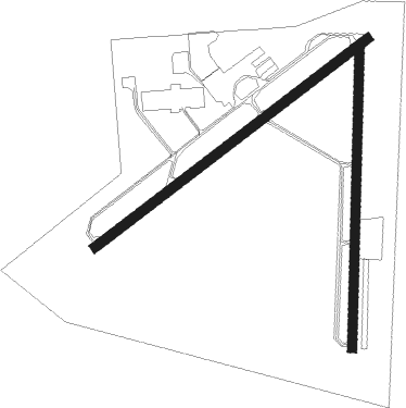
Mc Minnville - Mc Minnville Muni
Airport details
| Country | United States of America |
| State | Oregon |
| Region | K1 |
| Airspace | Seattle Ctr |
| Municipality | McMinnville |
| Elevation | 163ft (50m) |
| Timezone | GMT -8 |
| Coordinates | 45.19455, -123.13607 |
| Magnetic var | |
| Type | land |
| Available since | X-Plane v10.40 |
| ICAO code | KMMV |
| IATA code | MMV |
| FAA code | MMV |
Communication
| MC MINNVILLE MUNI ASOS | 135.675 |
| MC MINNVILLE MUNI CTAF/UNICOM | 123.000 |
| MC MINNVILLE MUNI PORTLAND Clearance DEL | 118.350 |
| MC MINNVILLE MUNI PORTLAND Approach/Departure | 126.000 |
Approach frequencies
| ILS-cat-I | RW22 | 110.9 | 18.00mi |
| 3° GS | RW22 | 110.9 | 18.00mi |
Nearby Points of Interest:
McMinnville Downtown Historic District
-Pioneer Hall
-Free Methodist Church
-John T. Hash House
-Evangelical United Brethren Church
-Baxter House
-Gottlieb Londershausen House
-Methodist Episcopal Parsonage
-Paul Londershausen House
-First Baptist Church
-Dr. Stuart House
-Evangelical Church of Lafayette
-J. C. Penney Building (Newberg, Oregon)
-Jesse Edwards House
-Minthorn Hall
-John Phillips House
-Spring Valley Presbyterian Church
-Sam Brown House
-J. S. and Melinda Waggener Farmstead
-Jones–Sherman House
-Carl E. Nelson House
-Bush–Breyman Block
-Grand Theatre
-Salem Downtown State Street – Commercial Street Historic District
-Adolph Block
Nearby beacons
| code | identifier | dist | bearing | frequency |
|---|---|---|---|---|
| UBG | NEWBERG VOR/DME | 11.6 | 45° | 117.40 |
| SL | TURNO (SALEM) NDB | 22.2 | 152° | 266 |
| PND | BANKS (PORTLAND) NDB | 26.4 | 12° | 356 |
| CBU | COLUMBIA (PORTLAND) TACAN | 32.4 | 53° | 109.20 |
| LWG | LEWISBURG (CORVALLIS) NDB | 35.3 | 193° | 225 |
| BTG | BATTLE GROUND VORTAC | 40.3 | 45° | 116.60 |
| CVO | CORVALLIS VOR/DME | 42.2 | 193° | 115.40 |
| ONP | NEWPORT VORTAC | 54.1 | 236° | 117.10 |
| AST | ASTORIA VOR/DME | 65.9 | 322° | 114 |
Instrument approach procedures
| runway | airway (heading) | route (dist, bearing) |
|---|---|---|
| RW04 | CRAAF (26°) | CRAAF PUCIV (18mi, 342°) 4900ft RIGOE (5mi, 65°) 3400ft |
| RW04 | TIYOT (60°) | TIYOT PUCIV (4mi, 31°) 4900ft RIGOE (5mi, 65°) 3400ft |
| RW04 | UBG (225°) | UBG PUCIV (27mi, 238°) 4900ft PUCIV (turn) 4900ft RIGOE (5mi, 65°) 3400ft |
| RNAV | RIGOE 3400ft JODVI (5mi, 65°) 1900ft VESYU (5mi, 65°) 369ft (6767mi, 110°) 563ft PUCIV (6781mi, 290°) 4900ft PUCIV (turn) | |
| RW22 | BTG (225°) | BTG TOCBU (25mi, 215°) 3100ft OZIER (5mi, 215°) 2900ft UNECE (3mi, 246°) 2500ft |
| RW22 | RAWER (263°) | RAWER OZIER (6mi, 303°) 2900ft UNECE (3mi, 246°) 2500ft |
| RW22 | UBG (225°) | UBG OZIER (4mi, 123°) 3800ft OZIER (turn) 2900ft UNECE (3mi, 246°) 2500ft |
| RNAV | UNECE 2500ft LIYEV (4mi, 246°) 1900ft KIGKE (2mi, 246°) 1100ft KMMV (3mi, 243°) 218ft OVUGE (3mi, 248°) PUCIV (13mi, 245°) 4900ft PUCIV (turn) |
Disclaimer
The information on this website is not for real aviation. Use this data with the X-Plane flight simulator only! Data taken with kind consent from X-Plane 12 source code and data files. Content is subject to change without notice.

