Mobile - Mobile Rgnl
Airport details
| Country | United States of America |
| State | Alabama |
| Region | K7 |
| Airspace | Houston Oceanic Ctr |
| Municipality | Mobile County |
| Elevation | 219ft (67m) |
| Timezone | GMT -6 |
| Coordinates | 30.68394, -88.24818 |
| Magnetic var | |
| Type | land |
| Available since | X-Plane v10.40 |
| ICAO code | KMOB |
| IATA code | MOB |
| FAA code | MOB |
Communication
| Mobile Rgnl ATIS | 124.750 |
| Mobile Rgnl CTAF | 118.300 |
| Mobile Rgnl UNICOM | 122.950 |
| Mobile Rgnl Clearance DEL | 119.850 |
| Mobile Rgnl Ground Control | 121.900 |
| Mobile Rgnl Tower | 118.300 |
| Mobile Rgnl Approach/Departure | 118.500 |
| Mobile Rgnl Approach/Departure | 121.000 |
Approach frequencies
| ILS-cat-I | RW33 | 111.5 | 18.00mi |
| ILS-cat-I | RW15 | 109.9 | 18.00mi |
| 3° GS | RW33 | 111.5 | 18.00mi |
| 3° GS | RW15 | 109.9 | 18.00mi |
Nearby Points of Interest:
Collins-Robinson House
-Collins-Marston House
-Roberts House
-Robert L. Spotswood House
-Ross Knox House
-James Arthur Morrison House
-Carolina Hall
-Stewartfield
-19th Century Spring Hill Neighborhood TR
-Sodality Chapel
-Spring Hill College Quadrangle
-Center–Gaillard House
-Beal-Gaillard House
-Pfau-Crichton Cottage
-Georgia Cottage
-Convent and Academy of the Visitation
-Arthur VanderSys House
-Wade Askew House
-George Levy House
-Jacob VanderSys House
-Ernest Megginson House
-D'Iberville Apartments
-Joseph M. Walker House
-J. E. Paterson House
-Greene-Marston House
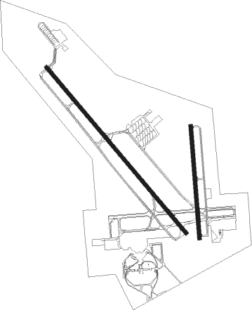
Runway info
Runway 15 / 33  | ||
| length | 2595m (8514ft) | |
| bearing | 140° / 320° | |
| width | 46m (150ft) | |
| surface | asphalt | |
| blast zone | 0m (0ft) / 255m (837ft) | |
| Runway 18 / 36 | ||
| length | 1338m (4390ft) | |
| bearing | 180° / 360° | |
| width | 46m (150ft) | |
| surface | asphalt | |
| blast zone | 0m (0ft) / 183m (600ft) | |
Nearby beacons
| code | identifier | dist | bearing | frequency |
|---|---|---|---|---|
| MOB | WISLE (MOBILE) NDB | 5.4 | 324° | 248 |
| SJI | SEMMES (MOBILE) VORTAC | 6.2 | 291° | 115.30 |
| BFM | BROOKLEY (MOBILE) VORTAC | 10.8 | 110° | 112.80 |
| GCV | GREENE CO. (LEAKESVILLE) VORTAC | 27.7 | 330° | 115.70 |
| BIX | KEESLER (BILOXI) TACAN | 38.9 | 248° | 111.80 |
| GPT | GULFPORT VORTAC | 45.9 | 252° | 109 |
| GP | BAYOU NDB | 48.7 | 258° | 360 |
| NUN | SAUFLEY (PENSACOLA) VOR | 48.8 | 103° | 108.80 |
| NPA | PENSACOLA TACAN | 52 | 109° | 117.20 |
| MVC | MONROEVILLE VORTAC | 65.5 | 49° | 116.80 |
Instrument approach procedures
| runway | airway (heading) | route (dist, bearing) |
|---|---|---|
| RW15 | BAYAS (142°) | BAYAS 2000ft |
| RNAV | BAYAS 2000ft CAYAT (7mi, 140°) 1800ft DICAD (2mi, 140°) 1020ft KMOB (3mi, 147°) 268ft (5315mi, 109°) 413ft JOTEN (5313mi, 289°) SAINT (6mi, 187°) 2000ft SAINT (turn) | |
| RW18 | CECAP (183°) | CECAP 2000ft |
| RNAV | CECAP 2000ft BAKAY (7mi, 180°) 2000ft DIDEC (3mi, 180°) 1120ft KMOB (3mi, 192°) 261ft (5315mi, 109°) 489ft IPAPE (5314mi, 289°) 2000ft IPAPE (turn) | |
| RW33 | PTREO (318°) | PTREO 1900ft |
| RNAV | PTREO 1900ft JABAK (7mi, 320°) 1900ft FANEP (3mi, 320°) 1060ft KMOB (3mi, 312°) 270ft (5315mi, 109°) 700ft SQWID (5327mi, 289°) 2000ft SQWID (turn) | |
| RW36 | IPAPE (357°) | IPAPE 2000ft |
| RNAV | IPAPE 2000ft EYEDY (7mi, 360°) 2000ft HISAL (3mi, 360°) 900ft KMOB (2mi, 341°) 269ft (5315mi, 109°) 482ft CECAP (5314mi, 289°) 2000ft CECAP (turn) |
Disclaimer
The information on this website is not for real aviation. Use this data with the X-Plane flight simulator only! Data taken with kind consent from X-Plane 12 source code and data files. Content is subject to change without notice.