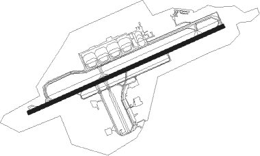
Martinsburg - Eastern Wv Rgnl Shepherd Fld
Airport details
| Country | United States of America |
| State | West Virginia |
| Region | K6 |
| Airspace | Washington Ctr |
| Municipality | Berkeley County |
| Elevation | 557ft (170m) |
| Timezone | GMT -5 |
| Coordinates | 39.40236, -77.98300 |
| Magnetic var | |
| Type | land |
| Available since | X-Plane v10.40 |
| ICAO code | KMRB |
| IATA code | MRB |
| FAA code | MRB |
Communication
| Eastern Wv Rgnl Shepherd Fld ASOS | 119.925 |
| Eastern Wv Rgnl Shepherd Fld UNICOM | 122.950 |
| Eastern Wv Rgnl Shepherd Fld CTAF | 124.300 |
| Eastern Wv Rgnl Shepherd Fld POTOMAC Clearance DEL | 132.075 |
| Eastern Wv Rgnl Shepherd Fld Ground Control | 121.800 |
| Eastern Wv Rgnl Shepherd Fld MARTINSBURG Tower | 124.300 |
| Eastern Wv Rgnl Shepherd Fld POTOMAC Approach/Departure | 126.100 |
Approach frequencies
| ILS-cat-I | RW26 | 108.3 | 18.00mi |
| 3° GS | RW26 | 108.3 | 18.00mi |
Nearby Points of Interest:
Tabler's Station Historic District
-Rauch House
-John Evans House
-George W. F. Mulliss House
-Continental Clay Brick Plant
-Elias Pitzer House
-Newcomer Mansion
-Henry J. Seibert II House
-The Bower
-Boydville Historic District
-Martinsburg Mining, Manufacturing & Improvement Co. Historic District
-Stone House Mansion
-Boomtown Historic District
-Boydville
-Adam Stephen House
-Downtown Martinsburg Historic District
-Green Hill Cemetery Historic District
-South Water Street Historic District
-East Martinsburg Historic District
-Opequon Golf Club
-Baltimore and Ohio and Related Industries Historic District
-Ar-Qua Springs
-Federal Aviation Administration Records Center
-Aspen Hall
-Traveller's Rest
Nearby beacons
| code | identifier | dist | bearing | frequency |
|---|---|---|---|---|
| MRB | MARTINSBURG VORTAC | 6.3 | 97° | 112.10 |
| HGR | HAGERSTOWN VOR | 18.6 | 23° | 109.80 |
| FDK | FREDERICK VOR | 28.2 | 89° | 109 |
| THS | SAINT THOMAS VORTAC | 31.9 | 3° | 115 |
| LDN | LINDEN VORTAC | 34.5 | 202° | 114.30 |
| AML | ARMEL (WASH.,D.C.) VOR/DME | 36.9 | 132° | 113.50 |
| CSN | CASANOVA VORTAC | 46 | 171° | 116.30 |
| LUA | CAVERNS (LURAY) NDB | 47.9 | 215° | 245 |
| GTN | GEORGETOWN (WASH., D.C.) NDB | 49 | 119° | 323 |
| DCA | WASHINGTON, D.C. VOR/DME | 54.8 | 120° | 111 |
| MSQ | NAILR (CULPEPER) NDB | 57 | 175° | 351 |
| DCA | OXONN (WASHINGTON) NDB | 58.6 | 124° | 332 |
| SYS | STOYSTOWN (SOMERSET) NDB | 59.5 | 306° | 209 |
| DAA | DAVEE (FT BELVOIR) NDB | 60.3 | 130° | 223 |
| CX | LATLE (HARRISBURG) NDB | 64.8 | 52° | 219 |
| JST | JOHNSTOWN VOR/DME | 67.4 | 317° | 113 |
| HAR | HARRISBURG VORTAC | 68.5 | 45° | 112.50 |
Departure and arrival routes
| Transition altitude | 18000ft |
| Transition level | 18000ft |
| SID end points | distance | outbound heading | |
|---|---|---|---|
| ALL | |||
| JDUBB4 | 156mi | 204° | |
| SCRAM6 | 128mi | 209° | |
| CLTCH3 | 111mi | 222° | |
| RW08 | |||
| TRIXY5 | 35mi | 202° | |
| RW26 | |||
| TRIXY5 | 35mi | 202° | |
| STAR starting points | distance | inbound heading | |
|---|---|---|---|
| ALL | |||
| PRIVO2 | 42.2 | 199° | |
| HYPER8 | 71.2 | 247° | |
| TRSTN3 | 79.6 | 351° | |
Instrument approach procedures
| runway | airway (heading) | route (dist, bearing) |
|---|---|---|
| RW08 | CAPON (78°) | CAPON JOSRU (8mi, 83°) 4100ft |
| RW08 | MRB (277°) | MRB JOSRU (20mi, 262°) 4100ft JOSRU (turn) 4100ft |
| RNAV | JOSRU 4100ft WAVMU (6mi, 75°) 3000ft VUCUR (3mi, 75°) 2080ft YASUT (2mi, 75°) 1280ft KMRB (3mi, 75°) 615ft (4849mi, 117°) 815ft BURGY (4838mi, 297°) 3400ft BURGY (turn) | |
| RW26 | MAPEL (255°) | MAPEL BURGY (7mi, 255°) 3400ft |
| RW26 | MRB (277°) | MRB BURGY (7mi, 53°) 4000ft BURGY (turn) 3400ft |
| RNAV | BURGY 3400ft CEBER (6mi, 255°) 2400ft KMRB (6mi, 255°) 600ft JOSRU (14mi, 255°) 4100ft JOSRU (turn) |
Holding patterns
| STAR name | hold at | type | turn | heading* | altitude | leg | speed limit |
|---|---|---|---|---|---|---|---|
| HYPER8 | BINNS | VHF | right | 68 (248)° | 1.0min timed | 265 | |
| HYPER8 | HYPER | VHF | left | 65 (245)° | 6001ft - 14000ft | 1.0min timed | 210 |
| PRIVO2 | DAFIX | VHF | left | 357 (177)° | 6001ft - 14000ft | 1.0min timed | 210 |
| TRSTN3 | JOHOF | VHF | right | 214 (34)° | DME 10.0mi | ICAO rules | |
| *) magnetic outbound (inbound) holding course | |||||||
Disclaimer
The information on this website is not for real aviation. Use this data with the X-Plane flight simulator only! Data taken with kind consent from X-Plane 12 source code and data files. Content is subject to change without notice.
