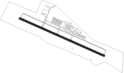
Martinsville - Martinsville - Blue Ridge
Airport details
| Country | United States of America |
| State | Virginia |
| Region | K6 |
| Airspace | Washington Ctr |
| Municipality | Henry County |
| Elevation | 939ft (286m) |
| Timezone | GMT -5 |
| Coordinates | 36.63075, -80.01833 |
| Magnetic var | |
| Type | land |
| Available since | X-Plane v10.40 |
| ICAO code | KMTV |
| IATA code | n/a |
| FAA code | MTV |
Communication
| Martinsville - Blue Ridge AWOS 3 | 118.450 |
| Martinsville - Blue Ridge CTAF/UNICOM | 122.700 |
| Martinsville - Blue Ridge GREENSBORO Approach/Departure | 124.350 |
Approach frequencies
| LOC | RW31 | 111.3 | 18.00mi |
Nearby Points of Interest:
John D. Bassett High School
-Grassdale Farm
-Aurora (Spencer, Virginia)
-Marshall Field and Company Clubhouse
-Fieldale Historic District
-Virginia Home
-Reynolds Homestead
-Belleview (Ridgeway, Virginia)
-Eltham Manor
-Spring Valley Rural Historic District
-Stoneleigh, Virginia
-Martinsville Fish Dam
-Edgewood (Stanleytown, Virginia)
-Fayette Street Historic District
-R.L. Stone House
-Martinsville Historic District
-Little Post Office
-Martinsville Novelty Corporation Factory
-Ingleside
-East Church Street-Starling Avenue Historic District
-John Waddey Carter House
-Scuffle Hill
-Beaver Creek Plantation
-Dry Bridge School
-Fairy Stone State Park
Nearby beacons
| code | identifier | dist | bearing | frequency |
|---|---|---|---|---|
| UV | BALES (MARTINSVILLE) NDB | 5.4 | 112° | 396 |
| SIF | SLAMMER (REIDSVILLE) NDB | 19.3 | 134° | 423 |
| DAN | DANVILLE VOR | 33 | 95° | 113.10 |
| IN | REENO (WINSTON SALEM) NDB | 34.3 | 195° | 317 |
| VIT | VINTON (ROANOKE) NDB | 35 | 13° | 277 |
| GSO | GREENSBORO VORTAC | 35.1 | 176° | 116.20 |
| TEC | TECH (BLACKSBURG) NDB | 39.3 | 326° | 368 |
| ODR | WOODRUM (ROANOKE) VOR | 41.6 | 3° | 114.90 |
| ROA | ROANOKE VOR/DME | 42.8 | 356° | 109.40 |
| PSK | PULASKI (DUBLIN) VORTAC | 43.2 | 303° | 116.80 |
| HB | ALAMM NDB | 44.4 | 146° | 361 |
| HUR | PERSON (ROXBORO) NDB | 51.8 | 113° | 220 |
| LIB | LIBERTY VORTAC | 52.9 | 154° | 113 |
| LYH | LYNCHBURG VOR/DME | 53 | 51° | 109.20 |
| LY | BOJAR (LYNCHBURG) NDB | 53.1 | 51° | 385 |
| RU | ROVDY (SALISBURY) NDB | 58.5 | 208° | 275 |
Instrument approach procedures
| runway | airway (heading) | route (dist, bearing) |
|---|---|---|
| RW13 | ALMAA (113°) | ALMAA 5800ft |
| RW13 | HOCUS (89°) | HOCUS ALMAA (9mi, 33°) 5800ft |
| RW13 | HUSIR (141°) | HUSIR ALMAA (9mi, 214°) 5800ft |
| RNAV | ALMAA 5800ft AREVE (7mi, 113°) 4300ft AIRER (5mi, 113°) 2400ft KMTV (4mi, 113°) 981ft (4925mi, 115°) 1301ft ULAKE (4909mi, 295°) 3000ft ULAKE (turn) | |
| RW31 | ULAKE (293°) | ULAKE 3000ft |
| RNAV | ULAKE 3000ft UBWAY (12mi, 294°) 2600ft ZAGUP (3mi, 293°) 1800ft KMTV (3mi, 293°) 952ft (4925mi, 115°) 1800ft ULAKE (4909mi, 295°) 3000ft ULAKE (turn) |
Disclaimer
The information on this website is not for real aviation. Use this data with the X-Plane flight simulator only! Data taken with kind consent from X-Plane 12 source code and data files. Content is subject to change without notice.
