Moses Lake - Grant Co Intl
Airport details
| Country | United States of America |
| State | Washington |
| Region | K1 |
| Airspace | Seattle Ctr |
| Municipality | Grant County |
| Elevation | 1185ft (361m) |
| Timezone | GMT -8 |
| Coordinates | 47.20858, -119.31914 |
| Magnetic var | |
| Type | land |
| Available since | X-Plane v10.40 |
| ICAO code | KMWH |
| IATA code | MWH |
| FAA code | MWH |
Communication
| Grant Co Intl ATIS | 119.050 |
| Grant Co Intl CTAF | 118.250 |
| Grant Co Intl UNICOM | 122.950 |
| Grant Co Intl Ground Control | 121.900 |
| Grant Co Intl Tower | 118.250 |
| Grant Co Intl Tower | 128.000 |
| Grant Co Intl Approach/Departure | 126.400 |
| Grant Co Intl Approach/Departure | 134.350 |
Approach frequencies
| ILS-cat-I | RW32R | 109.5 | 18.00mi |
| 3° GS | RW32R | 109.5 | 18.00mi |
Nearby Points of Interest:
Grant County Courthouse
-Grand Coulee
-Drumheller Channels National Natural Landmark
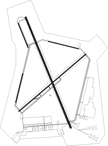
Runway info
Runway 14L / 32R  | ||
| length | 4116m (13504ft) | |
| bearing | 155° / 335° | |
| width | 61m (200ft) | |
| surface | asphalt | |
| blast zone | 255m (837ft) / 255m (837ft) | |
| Runway 4 / 22 | ||
| length | 3043m (9984ft) | |
| bearing | 64° / 244° | |
| width | 30m (100ft) | |
| surface | asphalt | |
| blast zone | 255m (837ft) / 255m (837ft) | |
| Runway 9 / 27 | ||
| length | 1064m (3491ft) | |
| bearing | 103° / 283° | |
| width | 27m (90ft) | |
| surface | concrete | |
| Runway 18 / 36 | ||
| length | 1019m (3343ft) | |
| bearing | 206° / 26° | |
| width | 23m (75ft) | |
| surface | asphalt | |
| blast zone | 28m (92ft) / 0m (0ft) | |
| Runway 14R / 32L | ||
| length | 895m (2936ft) | |
| bearing | 155° / 335° | |
| width | 23m (75ft) | |
| surface | concrete | |
Nearby beacons
| code | identifier | dist | bearing | frequency |
|---|---|---|---|---|
| MWH | MOSES LAKE VOR/DME | 0.1 | 45° | 115 |
| MW | PELLY (MOSES LAKE) NDB | 5.8 | 154° | 408 |
| EPH | EPHRATA VORTAC | 11 | 328° | 112.60 |
| EAT | WENATCHEE VOR/DME | 38 | 282° | 111 |
| PSC | PASCO VOR/DME | 56.9 | 168° | 109.80 |
Instrument approach procedures
| runway | airway (heading) | route (dist, bearing) |
|---|---|---|
| RW04-Y | EDSEW (81°) | EDSEW ONPIC (10mi, 101°) 4000ft |
| RW04-Y | MWH (225°) | MWH ONPIC (12mi, 243°) 4000ft ONPIC (turn) 4000ft |
| RW04-Y | RUBEL (61°) | RUBEL ONPIC (5mi, 56°) 4000ft |
| RNAV | ONPIC 4000ft UBGUY (6mi, 64°) 2800ft ZOBEM (3mi, 64°) 1680ft KMWH (2mi, 58°) 1239ft (6572mi, 112°) 1389ft YELUG (6565mi, 292°) WIPES (9mi, 26°) 4000ft WIPES (turn) | |
| RW04-Z | EDSEW (81°) | EDSEW ZIRVO (11mi, 93°) 3800ft HUSMI (2mi, 79°) 3300ft |
| RW04-Z | RUBEL (61°) | RUBEL ONPIC (5mi, 56°) 4300ft WESKO (2mi, 64°) 3800ft HUSMI (2mi, 64°) 3300ft |
| RNAV | HUSMI 3300ft UBGUY (2mi, 64°) 2800ft KMWH (6mi, 62°) 1239ft YELUG (7mi, 66°) WIPES (9mi, 26°) 4000ft WIPES (turn) | |
| RW14LY | MWH (225°) | MWH JUKRI (13mi, 334°) 4000ft JUKRI (turn) 4000ft |
| RW14LY | QUINT (91°) | QUINT JUKRI (23mi, 68°) 5200ft JUKRI (turn) 4000ft |
| RW14LY | WIPES (226°) | WIPES JUKRI (13mi, 271°) 4200ft JUKRI (turn) 4000ft |
| RNAV | JUKRI 4000ft ILARE (6mi, 155°) 3000ft VIMFY (4mi, 155°) 1780ft KMWH (3mi, 155°) 1220ft (6572mi, 112°) 1368ft HEDBI (6572mi, 292°) UPBOB (15mi, 131°) 4000ft UPBOB (turn) | |
| RW14LZ | UPBOB (317°) | UPBOB SUGSE (18mi, 346°) 5000ft WEXAG (5mi, 5°) 5000ft HOTEP (5mi, 315°) 4000ft ZITNI (4mi, 259°) 3800ft |
| RW14LZ | WIPES (226°) | WIPES WOXOL (3mi, 267°) 5000ft HUGTI (4mi, 243°) 4100ft ZITNI (1mi, 222°) 3800ft |
| RNAV | ZITNI 3800ft LACIP (1mi, 233°) 3600ft JOMPU (2mi, 233°) HODPA (3mi, 197°) KMWH (4mi, 155°) 1220ft JIDAG (6mi, 154°) WOTKU (10mi, 76°) BATUM (6mi, 329°) 4000ft BATUM (turn) | |
| RW22-Y | EPH (148°) | EPH MALEE (14mi, 99°) 4000ft MALEE (turn) 4000ft |
| RW22-Y | MWH (225°) | MWH MALEE (12mi, 65°) 4000ft MALEE (turn) 4000ft |
| RW22-Y | SUBDY (258°) | SUBDY MALEE (11mi, 270°) 4000ft |
| RNAV | MALEE 4000ft IPROF (6mi, 244°) 2800ft EVUCU (3mi, 244°) 1920ft KMWH (3mi, 248°) 1203ft (6572mi, 112°) 1353ft ONPIC (6584mi, 291°) 4000ft ONPIC (turn) | |
| RW22-Z | EPH (148°) | EPH YERUD (8mi, 84°) 4000ft OPMIE (8mi, 149°) 3100ft |
| RW22-Z | SUBDY (258°) | SUBDY MALEE (11mi, 270°) 4000ft OPMIE (4mi, 244°) 3100ft |
| RNAV | OPMIE 3100ft IPROF (2mi, 244°) 2800ft KMWH (6mi, 246°) 1203ft ONPIC (12mi, 243°) 4000ft ONPIC (turn) | |
| RW32RY | FEBUS (61°) | FEBUS PEWYE (20mi, 84°) 4000ft IWKID (8mi, 78°) 4000ft |
| RW32RY | MWH (225°) | MWH IWKID (14mi, 155°) 4000ft IWKID (turn) 4000ft |
| RW32RY | ODECE (347°) | ODECE IWKID (7mi, 15°) 4000ft |
| RW32RY | SUBDY (258°) | SUBDY YUNUV (19mi, 215°) 4100ft IWKID (9mi, 258°) 4000ft |
| RW32RY | UPBOB (317°) | UPBOB IWKID (8mi, 291°) 4000ft |
| RNAV | IWKID 4000ft ZAVYO (8mi, 335°) 2800ft UKMEZ (3mi, 335°) 1720ft KMWH (3mi, 334°) 1222ft (6572mi, 112°) 1367ft JUKRI (6571mi, 292°) 4000ft JUKRI (turn) | |
| RW32RZ | COYYA (94°) | COYYA PLUSS (12mi, 105°) 8000ft CUSPI (10mi, 136°) 6000ft ZONOK (4mi, 104°) 4500ft ZETEK (5mi, 38°) 2900ft |
| RW32RZ | FEBUS (61°) | FEBUS JIBOD (14mi, 79°) 7100ft ZONOK (10mi, 79°) 4500ft ZETEK (5mi, 38°) 2900ft |
| RW32RZ | SUBDY (258°) | SUBDY WIDKO (10mi, 230°) 7700ft HIXOS (10mi, 230°) 5100ft ZETEK (6mi, 277°) 2900ft |
| RW32RZ | UPBOB (317°) | UPBOB IWKID (8mi, 291°) 4000ft ZOBLI (5mi, 335°) 3100ft ZETEK (turn) 2900ft |
| RNAV | ZETEK 2900ft ZAVYO (2mi, 335°) 2800ft KMWH (6mi, 334°) 1222ft FORWY (6mi, 335°) WEPMO (9mi, 76°) BATUM (6mi, 148°) 4000ft BATUM (turn) |
Disclaimer
The information on this website is not for real aviation. Use this data with the X-Plane flight simulator only! Data taken with kind consent from X-Plane 12 source code and data files. Content is subject to change without notice.