Middletown - Hook Field Muni
Airport details
| Country | United States of America |
| State | Ohio |
| Region | K5 |
| Airspace | Indianapolis Ctr |
| Municipality | Middletown |
| Elevation | 648ft (198m) |
| Timezone | GMT -5 |
| Coordinates | 39.53181, -84.39645 |
| Magnetic var | |
| Type | land |
| Available since | X-Plane v10.40 |
| ICAO code | KMWO |
| IATA code | n/a |
| FAA code | MWO |
Communication
| Hook Field Muni AWOS 3 | 120.025 |
| Hook Field Muni CTAF/UNICOM | 123.000 |
| Hook Field Muni DAYTON Approach | 118.850 |
| Hook Field Muni DAYTON Departure | 126.500 |
Approach frequencies
| LOC | RW23 | 111.1 | 18.00mi |
Nearby Points of Interest:
John B. Tytus House
-South Main Street District
-Harding-Jones Paper Company District
-Great Mound
-Franklin Post Office
-Christian Ehresman Farm
-Mann Mound
-Charles Butler House
-John Augspurger Farm No. 2
-John Augspurger Farm No. 1
-Hughes Manor
-Henry P. Deuscher House
-John Kennel, Sr., Farm
-Christian Iutzi Farm
-Samuel Augspurger Farm
-John Kennel Jr. Farm
-Frederick Augspurger Farm
-Augspurger Schoolhouse
-Augspurger Paper Company Rowhouse 1
-Mill Office and Post Office
-Samuel Augspurger House
-Augspurger Paper Company Rowhouse 2
-Augspurger Grist Mill
-Dr. Aaron Wright House
-Springboro Historic District
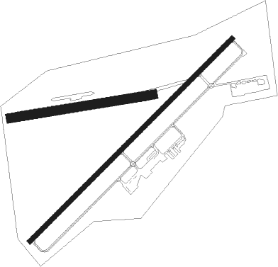
Runway info
Runway 5 / 23  | ||
| length | 1858m (6096ft) | |
| bearing | 56° / 236° | |
| width | 30m (98ft) | |
| surface | asphalt | |
| displ threshold | 0m (0ft) / 91m (299ft) | |
| Runway 08 / 26 | ||
| length | 935m (3068ft) | |
| bearing | 86° / 266° | |
| width | 60m (197ft) | |
| surface | grass | |
| displ threshold | 296m (971ft) / 0m (0ft) | |
Nearby beacons
| code | identifier | dist | bearing | frequency |
|---|---|---|---|---|
| HKF | HOOK FIELD (MIDDLETOWN) NDB | 3 | 237° | 239 |
| MW | ONIDA (MIDDLETOWN) NDB | 4.3 | 58° | 223 |
| AT | BRUNY (DAYTON) NDB | 19.1 | 11° | 315 |
| FFO | PATTERSON (DAYTON) TACAN | 23.3 | 50° | 115.20 |
| RID | RICHMOND VOR/DME | 24.4 | 297° | 110.60 |
| HW | CUBLA (WILMINGTON) NDB | 26.4 | 109° | 299 |
| MXQ | MIDWEST (WILMINGTON) VOR/DME | 28.2 | 100° | 112.90 |
| PWF | SPORTYS (BATAVIA) NDB | 28.5 | 158° | 245 |
| DQN | DAYTON VOR/DME | 29.1 | 360° | 114.50 |
| IL | AIRBO (WILMINGTON) NDB | 30.5 | 93° | 407 |
| SGH | DME | 31.3 | 61° | 113.20 |
| XSF | SPRINGFIELD TACAN | 31.5 | 61° | 133.80 |
| CVG | CINCINNATI VORTAC | 34.1 | 211° | 117.30 |
| SQ | PNTHR (CONNERSVILLE) NDB | 36.9 | 288° | 227 |
| HLB | BATESVILLE NDB | 41.5 | 258° | 254 |
| AWW | WINCHESTER NDB | 45.2 | 320° | 212 |
| UWL | NEW CASTLE NDB | 47.4 | 291° | 385 |
| ROD | ROSEWOOD VORTAC | 48.2 | 25° | 117.50 |
| FLM | FALMOUTH VOR/DME | 53.1 | 174° | 117 |
| JN | BALLL (MUNCIE) NDB | 57.7 | 305° | 365 |
| MI | BALLL (MUNCIE) NDB | 57.7 | 305° | 365 |
| MIE | MUNCIE VOR/DME | 62.5 | 305° | 114.40 |
Departure and arrival routes
| Transition altitude | 18000ft |
| Transition level | 18000ft |
| STAR starting points | distance | inbound heading | |
|---|---|---|---|
| ALL | |||
| DANEI3 | 53.3 | 228° | |
Instrument approach procedures
| runway | airway (heading) | route (dist, bearing) |
|---|---|---|
| RW05 | AVIDE (88°) | AVIDE CISPO (10mi, 132°) 3100ft |
| RW05 | CISPO (56°) | CISPO 3100ft |
| RW05 | MOAKS (320°) | MOAKS DOSVE (12mi, 264°) 3100ft CISPO (10mi, 312°) 3100ft |
| RNAV | CISPO 3100ft FABVU (8mi, 56°) 2000ft HASPU (2mi, 56°) 1320ft KMWO (2mi, 55°) 687ft (5146mi, 115°) 1051ft YEBTO (5136mi, 295°) 3100ft YEBTO (turn) | |
| RW23 | FRAAM (146°) | FRAAM WIBAR (11mi, 83°) 3100ft YEBTO (10mi, 132°) 3100ft |
| RW23 | PRUDE (283°) | PRUDE ZABSI (8mi, 325°) 3100ft YEBTO (10mi, 312°) 3100ft |
| RW23 | YEBTO (237°) | YEBTO 3100ft |
| RNAV | YEBTO 3100ft VOYUV (9mi, 237°) 2000ft KMWO (5mi, 237°) 695ft (5146mi, 115°) 1800ft YEBTO (5136mi, 295°) 3100ft YEBTO (turn) |
Holding patterns
| STAR name | hold at | type | turn | heading* | altitude | leg | speed limit |
|---|---|---|---|---|---|---|---|
| DANEI3 | DANEI | VHF | right | 73 (253)° | 1.0min timed | ICAO rules | |
| *) magnetic outbound (inbound) holding course | |||||||
Disclaimer
The information on this website is not for real aviation. Use this data with the X-Plane flight simulator only! Data taken with kind consent from X-Plane 12 source code and data files. Content is subject to change without notice.