Monticello - Monticello Regl
Airport details
| Country | United States of America |
| State | Iowa |
| Region | K3 |
| Airspace | Chicago Ctr |
| Municipality | Monticello |
| Elevation | 833ft (254m) |
| Timezone | GMT -6 |
| Coordinates | 42.22036, -91.16330 |
| Magnetic var | |
| Type | land |
| Available since | X-Plane v10.40 |
| ICAO code | KMXO |
| IATA code | n/a |
| FAA code | MXO |
Communication
| Monticello Regl AWOS 3 | 119.275 |
| Monticello Regl CTAF/UNICOM | 122.800 |
| Monticello Regl CEDAR RAPIDS Approach/Departure | 134.050 |
Nearby Points of Interest:
Odd Fellows Hall
-St. Luke's Methodist Church
-S.S. Farwell House
-Corbett's/Eby's Mill Bridge
-Sauser-Lane House
-Col. William T. and Elizabeth C. Shaw House
-Anamosa Main Street Historic District
-Anamosa State Penitentiary
-Edmund and Mary Ann Walworth Booth House
-Anamosa Public Library
-Jones County Courthouse
-Rick's Brewery
-Lower Road Bridge
-Farm No. 1, Iowa Men's Reformatory
-Anamosa State Penitentiary Cemetery
-Wapsipinicon State Park
-John A. Green Estate
-St. Joseph's Roman Catholic Church
-Grant Wood's "Fall Plowing" Rural Historic Landscape District
-Dr. Martin H. Caulkins House and Office
-Canton School
-Central School
-St. Patrick's Church-Garryowen
-Allen House
-Memorial Building
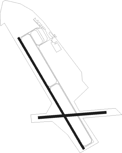
Runway info
Runway 15 / 33  | ||
| length | 1342m (4403ft) | |
| bearing | 146° / 326° | |
| width | 23m (75ft) | |
| surface | concrete | |
| Runway 09 / 27 | ||
| length | 696m (2283ft) | |
| bearing | 90° / 270° | |
| width | 27m (90ft) | |
| surface | grass | |
Nearby beacons
| code | identifier | dist | bearing | frequency |
|---|---|---|---|---|
| DBQ | DUBUQUE VORTAC | 22.9 | 68° | 115.80 |
| DB | ZILOM (DUBUQUE) NDB | 25.8 | 80° | 341 |
| CID | CEDAR RAPIDS VOR/DME | 34.2 | 242° | 114.10 |
| IIB | WAPSIE (INDEPENDENCE) NDB | 37.6 | 286° | 206 |
| CVA | DAVENPORT VORTAC | 43.2 | 127° | 113.80 |
| FN | HILLZ (CLINTON) NDB | 44.5 | 121° | 517 |
| IOW | IOWA CITY VOR/DME | 46.6 | 213° | 116.20 |
| DDD | CITY DME | 51.2 | 179° | 116.50 |
| MZV | MOLINE VOR/DME | 58.9 | 150° | 114.40 |
Instrument approach procedures
| runway | airway (heading) | route (dist, bearing) |
|---|---|---|
| RW15 | OREVY (146°) | OREVY 3000ft |
| RNAV | OREVY 3000ft ILETY (7mi, 146°) 2600ft TUNUC (3mi, 146°) 1500ft KMXO (2mi, 146°) 868ft (5457mi, 115°) 1232ft PBURG (5451mi, 295°) 3000ft PBURG (turn) | |
| RW33 | PBURG (327°) | PBURG 3000ft |
| RNAV | PBURG 3000ft YOMNG (7mi, 327°) 2600ft YIXIR (3mi, 327°) 1520ft KMXO (2mi, 327°) 860ft (5457mi, 115°) 1220ft OREVY (5462mi, 295°) 3000ft OREVY (turn) |
Disclaimer
The information on this website is not for real aviation. Use this data with the X-Plane flight simulator only! Data taken with kind consent from X-Plane 12 source code and data files. Content is subject to change without notice.