New Orleans - New Orleans N A S
Airport details
| Country | United States of America |
| State | Louisiana |
| Region | K4 |
| Airspace | Houston Oceanic Ctr |
| Municipality | Belle Chasse |
| Elevation | 1ft (0m) |
| Timezone | GMT -6 |
| Coordinates | 29.82721, -90.02659 |
| Magnetic var | |
| Type | land |
| Available since | X-Plane v10.40 |
| ICAO code | KNBG |
| IATA code | NBG |
| FAA code | NBG |
Communication
| New Orleans N A S NAVY NEW ORLEANS Ground Control | 121.600 |
| New Orleans N A S NAVY NEW ORLEANS Tower | 123.800 |
| New Orleans N A S Approach/Departure | 123.850 |
Approach frequencies
| ILS-cat-I | RW04 | 109.5 | 18.00mi |
| 3° GS | RW04 | 109.5 | 18.00mi |
Nearby Points of Interest:
Mary Plantation House
-Promised Land
-Gretna Historic District
-Old Jefferson Parish Courthouse
-Kerner House
-George Washington Cable House
-St. Peter A.M.E. Church
-Adolph Meyer School
-Chalmette Unit of Jean Lafitte National Historical Park
-Aldrich–Genella House
-Robert E. Lee Monument
-St. Patrick's Church
-Jackson Barracks
-Gallier Hall
-Magnolia Projects
-John Minor Wisdom United States Court of Appeals Building
-United States Custom House
-Deluge
-National American Bank Building
-Karnofsky Tailor Shop–House
-St. Charles Streetcar Line
-1010 Common
-Louisiana State Bank Building
-Bank of Louisiana
-Orpheum Theater
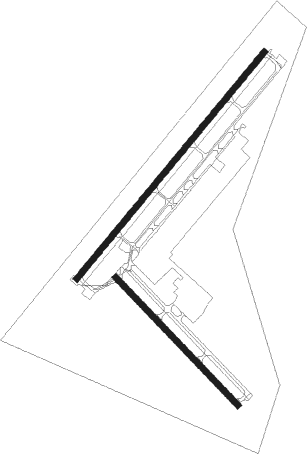
Runway info
Runway 4 / 22  | ||
| length | 3049m (10003ft) | |
| bearing | 48° / 228° | |
| width | 61m (200ft) | |
| surface | asphalt | |
| blast zone | 255m (837ft) / 255m (837ft) | |
| Runway 14 / 32 | ||
| length | 1831m (6007ft) | |
| bearing | 137° / 317° | |
| width | 61m (200ft) | |
| surface | asphalt | |
| blast zone | 0m (0ft) / 61m (200ft) | |
Nearby beacons
| code | identifier | dist | bearing | frequency |
|---|---|---|---|---|
| HRV | HARVEY (NEW ORLEANS) VORTAC | 1.8 | 46° | 114.10 |
| MS | KINTE (NEW ORLEANS) NDB | 22.7 | 298° | 338 |
| RQR | RESERVE VOR/DME | 33.1 | 295° | 110.80 |
| LEV | LEEVILLE (GRAND ISLE) VORTAC | 39.3 | 187° | 113.50 |
| TBD | TIBBY (THIBODAUX) VOR/DME | 42.9 | 259° | 112 |
| PCU | PICAYUNE VOR/DME | 46.6 | 22° | 113.95 |
| HS | HANCO (BAY ST LOUIS) NDB | 47.7 | 42° | 221 |
| HP | ANGER (HAMMOND) NDB | 51 | 333° | 212 |
| GP | BAYOU NDB | 59.8 | 53° | 360 |
| GPT | GULFPORT VORTAC | 60.3 | 59° | 109 |
Instrument approach procedures
| runway | airway (heading) | route (dist, bearing) |
|---|---|---|
| RW04 | GOING (19°) | GOING 2000ft MISSB (11mi, 344°) 2000ft |
| RW04 | MISSB (49°) | MISSB 2000ft |
| RW04 | OLEDD (80°) | OLEDD 2000ft MISSB (16mi, 99°) 2000ft |
| RNAV | MISSB 2000ft JERAN (6mi, 48°) 1500ft KNBG (5mi, 51°) 49ft (5407mi, 108°) 380ft DORPS (5405mi, 288°) BIBLY (9mi, 48°) 2100ft BIBLY (turn) 6000ft | |
| RW14 | JASPO (146°) | JASPO 4000ft CETVA (8mi, 164°) 3000ft |
| RNAV | CETVA 3000ft ELUKE (6mi, 138°) 2000ft KNBG (6mi, 133°) 48ft (5407mi, 108°) 402ft SULPA (5399mi, 288°) 2100ft SULPA (turn) 6000ft | |
| RW22 | KOCEL (264°) | KOCEL 2000ft BIBLY (10mi, 310°) 2000ft |
| RNAV | BIBLY 2000ft MACKV (6mi, 228°) 1600ft KNBG (6mi, 226°) 40ft (5407mi, 108°) 402ft AMUPE (5408mi, 288°) MISSB (9mi, 228°) 2000ft MISSB (turn) 6000ft | |
| RW32 | SULPA (327°) | SULPA 2100ft |
| RNAV | SULPA 2100ft HOSEK (9mi, 332°) 2000ft KNBG (7mi, 320°) 48ft (5407mi, 108°) 402ft MISSB (5414mi, 288°) 2000ft MISSB (turn) 6000ft |
Disclaimer
The information on this website is not for real aviation. Use this data with the X-Plane flight simulator only! Data taken with kind consent from X-Plane 12 source code and data files. Content is subject to change without notice.