China Lake - China Lake Naws
Airport details
| Country | United States of America |
| State | California |
| Region | K2 |
| Airspace | Los Angeles Ctr |
| Municipality | Kern County |
| Elevation | 2283ft (696m) |
| Timezone | GMT -8 |
| Coordinates | 35.68564, -117.69182 |
| Magnetic var | |
| Type | land |
| Available since | X-Plane v10.40 |
| ICAO code | KNID |
| IATA code | NID |
| FAA code | NID |
Communication
| China Lake Naws Tower | 120.150 |
| China Lake Naws JOSHUA Approach/Departure | 133.650 |
Nearby Points of Interest:
Walker Pass
-Coso Rock Art District
-Burro Schmidt Tunnel
-Last Chance Canyon
-Coso Hot Springs
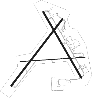
Runway info
Runway 3 / 21  | ||
| length | 3047m (9997ft) | |
| bearing | 48° / 228° | |
| width | 61m (200ft) | |
| surface | asphalt | |
| blast zone | 255m (837ft) / 255m (837ft) | |
| Runway 14 / 32 | ||
| length | 2750m (9022ft) | |
| bearing | 149° / 329° | |
| width | 61m (200ft) | |
| surface | asphalt | |
| blast zone | 255m (837ft) / 255m (837ft) | |
| Runway 8 / 26 | ||
| length | 2373m (7785ft) | |
| bearing | 91° / 271° | |
| width | 23m (75ft) | |
| surface | asphalt | |
| displ threshold | 0m (0ft) / 210m (689ft) | |
Nearby beacons
| code | identifier | dist | bearing | frequency |
|---|---|---|---|---|
| NID | CHINA LAKE TACAN | 0.1 | 30° | 111.60 |
| EDW | EDWARDS VORTAC | 42.2 | 183° | 116.40 |
Departure and arrival routes
| Transition altitude | 18000ft |
| Transition level | 18000ft |
| SID end points | distance | outbound heading | |
|---|---|---|---|
| RW03 | |||
| ROSIE4 | 99mi | 222° | |
| RW14 | |||
| SALTD7 | 81mi | 126° | |
| ROSIE4 | 99mi | 222° | |
| RW21 | |||
| SALTD7 | 81mi | 126° | |
| ROSIE4 | 99mi | 222° | |
| RW26 | |||
| ROSIE4 | 99mi | 222° | |
| RW32 | |||
| SALTD7 | 81mi | 126° | |
| ROSIE4 | 99mi | 222° | |
Instrument approach procedures
| runway | airway (heading) | route (dist, bearing) |
|---|---|---|
| RW03 | MIGPE (52°) | MIGPE 7600ft SAVEW (7mi, 57°) 5400ft |
| RNAV | SAVEW 5400ft POLSE (2mi, 48°) 4800ft OYSER (2mi, 48°) 4100ft KNID (7mi, 50°) 2324ft (6737mi, 107°) 3600ft JEBUR (6734mi, 287°) PEXOE (11mi, 236°) MIGPE (11mi, 286°) 7600ft MIGPE (turn) 7600ft | |
| RW32 | CIBIV (18°) | CIBIV 6500ft CAMAD (12mi, 64°) 6500ft |
| RNAV | CAMAD 6500ft PIBAE (6mi, 360°) 5300ft KATIE (4mi, 331°) 4400ft EKJER (2mi, 331°) 3600ft KNID (5mi, 327°) 2291ft (6737mi, 107°) 2800ft CIBIV (6749mi, 287°) 8100ft CIBIV (turn) 13000ft |
Disclaimer
The information on this website is not for real aviation. Use this data with the X-Plane flight simulator only! Data taken with kind consent from X-Plane 12 source code and data files. Content is subject to change without notice.