Cherry Point - Cherry Point Mcas
Airport details
| Country | United States of America |
| State | North Carolina |
| Region | K7 |
| Airspace | Washington Ctr |
| Municipality | Havelock |
| Elevation | 26ft (8m) |
| Timezone | GMT -5 |
| Coordinates | 34.90317, -76.88078 |
| Magnetic var | |
| Type | land |
| Available since | X-Plane v10.40 |
| ICAO code | KNKT |
| IATA code | NKT |
| FAA code | NKT |
Communication
| Cherry Point MCAS Clearance DEL | 125.950 |
| Cherry Point MCAS Ground Control | 128.625 |
| Cherry Point MCAS Tower | 121.300 |
| Cherry Point MCAS Approach/Departure | 119.350 |
| Cherry Point MCAS Approach/Departure | 119.750 |
| Cherry Point MCAS Approach/Departure | 124.100 |
| Cherry Point MCAS Approach/Departure | 132.575 |
Nearby Points of Interest:
New Bern Battlefield Site
-China Grove (Oriental, North Carolina)
-Mount Shiloh Missionary Baptist Church
-Morehead City Historic District
-Ocracoke Historic District
-Morehead City Municipal Building
-Isaac Taylor House
-York-Gordon House
-New Bern City Hall
-First Baptist Church
-Benjamin Smith House
-Christ Episcopal Church and Parish House
-Coor-Bishop House
-Gull Harbor
-Coor-Gaston House
-Hawks House
-Stevenson House
-Bryan House and Office
-Smith-Whitford House
-Eli Smallwood House
-Dr. Earl S. Sloan House
-Slover-Bradham House
-Jones-Jarvis House
-Attmore-Oliver House
-Jerkins-Duffy House
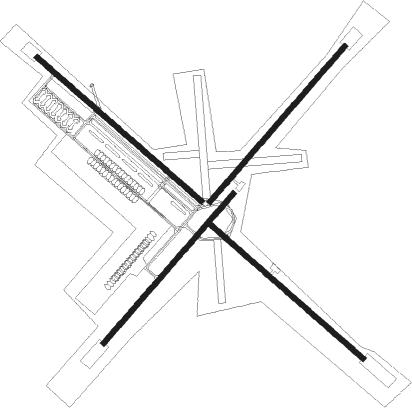
Runway info
Runway 14L / 32R  | ||
| length | 2741m (8993ft) | |
| bearing | 130° / 310° | |
| width | 61m (200ft) | |
| surface | asphalt | |
| Runway 14R / 32L | ||
| length | 2563m (8409ft) | |
| bearing | 130° / 310° | |
| width | 61m (200ft) | |
| surface | asphalt | |
| displ threshold | 258m (846ft) / 0m (0ft) | |
| Runway 5L / 23R | ||
| length | 2591m (8501ft) | |
| bearing | 51° / 231° | |
| width | 61m (200ft) | |
| surface | asphalt | |
| displ threshold | 286m (938ft) / 0m (0ft) | |
| Runway 5R / 23L | ||
| length | 2498m (8196ft) | |
| bearing | 51° / 231° | |
| width | 61m (200ft) | |
| surface | asphalt | |
Nearby beacons
| code | identifier | dist | bearing | frequency |
|---|---|---|---|---|
| NKT | CHERRY POINT TACAN | 0.2 | 99° | 112.80 |
| EW | KAFTI (NEW BERN) NDB | 12 | 301° | 362 |
| EWN | NEW BERN VOR/DME | 13 | 316° | 113.60 |
| NCA | NEW RIVER TACAN | 29.9 | 251° | 115.40 |
| DIW | DIXON NDB | 34.6 | 240° | 198 |
| RNW | CHOCOWINITY NDB | 38 | 340° | 388 |
| OA | ELLAS (JACKSONVILLE) NDB | 41.6 | 260° | 261 |
| ISO | KINSTON VORTAC | 43.5 | 305° | 109.60 |
| IS | STALS (KINSTON) NDB | 45 | 293° | 276 |
| AQE | ALWOOD (GREENVILLE) NDB | 53.9 | 329° | 230 |
| GM | WILZE NDB | 57.2 | 239° | 205 |
| ILM | WILMINGTON VORTAC | 59.2 | 241° | 117 |
| IL | AIRLI (WILMINGTON) NDB | 64.8 | 234° | 281 |
Instrument approach procedures
| runway | airway (heading) | route (dist, bearing) |
|---|---|---|
| RW05R | FEELY (130°) | FEELY 3100ft OSPIE (14mi, 201°) 3100ft WEDUV (9mi, 130°) 3100ft |
| RNAV | WEDUV 3100ft ICORE (6mi, 51°) 1600ft KNKT (6mi, 50°) 78ft (4761mi, 114°) 429ft GRAVY (4757mi, 294°) 3100ft GRAVY (turn) 6000ft | |
| RW14L | HULAN (130°) | HULAN 3100ft |
| RW14L | ISO (125°) | ISO HULAN (32mi, 123°) 3100ft |
| RNAV | HULAN 3100ft NAYEP (6mi, 129°) 1600ft KNKT (6mi, 130°) 74ft (4761mi, 114°) 429ft JUNIR (4751mi, 294°) 3100ft JUNIR (turn) 4000ft | |
| RW23R | FEELY (130°) | FEELY 3100ft JIBUS (13mi, 66°) 3100ft WASEB (11mi, 131°) 3000ft |
| RNAV | WASEB 3000ft JIMEK (6mi, 231°) 1600ft KNKT (6mi, 231°) 73ft (4761mi, 114°) 400ft ICORE (4764mi, 294°) 3100ft ICORE (turn) 3100ft | |
| RW32L | FEELY (130°) | FEELY 3100ft JUNIR (27mi, 130°) 3100ft JUNIR (turn) 3100ft |
| RNAV | JUNIR 3100ft KKING (6mi, 309°) 1600ft KNKT (6mi, 311°) 67ft (4761mi, 114°) 429ft HULAN (4770mi, 294°) 3100ft HULAN (turn) 6000ft |
Disclaimer
The information on this website is not for real aviation. Use this data with the X-Plane flight simulator only! Data taken with kind consent from X-Plane 12 source code and data files. Content is subject to change without notice.