Kingsville - Kingsville Nas
Airport details
| Country | United States of America |
| State | Texas |
| Region | K4 |
| Airspace | Houston Oceanic Ctr |
| Municipality | Kleberg County |
| Elevation | 48ft (15m) |
| Timezone | GMT -6 |
| Coordinates | 27.50451, -97.80829 |
| Magnetic var | |
| Type | land |
| Available since | X-Plane v10.40 |
| ICAO code | KNQI |
| IATA code | NQI |
| FAA code | NQI |
Communication
| KINGSVILLE NAS Tower | 124.100 |
| KINGSVILLE NAS Approach | 119.900 |
Approach frequencies
| ILS-cat-I | RW13R | 110.9 | 18.00mi |
| 3° GS | RW13R | 110.9 | 18.00mi |
Nearby Points of Interest:
John B. Ragland Mercantile Company Building
-King Ranch
-Brooks County Courthouse
-Novillo Line Camp
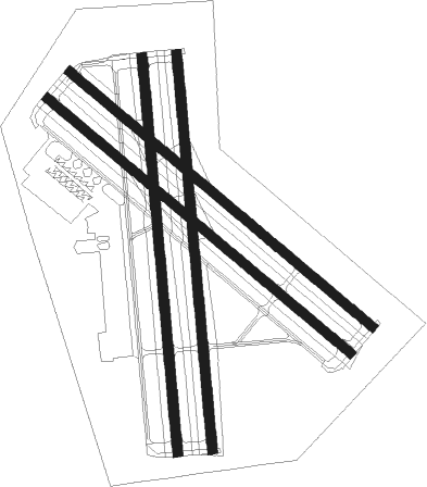
Runway info
Runway 13L / 31R  | ||
| length | 2442m (8012ft) | |
| bearing | 131° / 311° | |
| width | 61m (200ft) | |
| surface | asphalt | |
| Runway 13R / 31L | ||
| length | 2442m (8012ft) | |
| bearing | 131° / 311° | |
| width | 61m (200ft) | |
| surface | asphalt | |
| Runway 17L / 35R | ||
| length | 2447m (8028ft) | |
| bearing | 179° / 359° | |
| width | 61m (200ft) | |
| surface | asphalt | |
| Runway 17R / 35L | ||
| length | 2447m (8028ft) | |
| bearing | 179° / 359° | |
| width | 61m (200ft) | |
| surface | asphalt | |
Nearby beacons
| code | identifier | dist | bearing | frequency |
|---|---|---|---|---|
| NQI | KINGSVILLE TACAN | 0.3 | 153° | 117.80 |
| ALI | ALICE VOR | 18.1 | 318° | 114.50 |
| NOG | ORANGE GROVE TACAN | 26.5 | 329° | 133.60 |
| NGP | TRUAX (CORPUS CHRISTI) TACAN | 29.4 | 71° | 114 |
| CRP | CORPUS CHRISTI VORTAC | 30.7 | 42° | 115.50 |
| EOC | COYOTE (ENCINO) NDB | 44.8 | 212° | 232 |
Disclaimer
The information on this website is not for real aviation. Use this data with the X-Plane flight simulator only! Data taken with kind consent from X-Plane 12 source code and data files. Content is subject to change without notice.