Imperial Beach
Airport details
| Country | United States of America |
| State | California |
| Region | K2 |
| Airspace | Los Angeles Ctr |
| Municipality | Imperial Beach |
| Elevation | 22ft (7m) |
| Timezone | GMT -8 |
| Coordinates | 32.56540, -117.11684 |
| Magnetic var | |
| Type | land |
| Available since | X-Plane v10.40 |
| ICAO code | KNRS |
| IATA code | NRS |
| FAA code | NRS |
Communication
| Imperial Beach Tower | 120.650 |
Nearby Points of Interest:
Tijuana River Estuary
-United States Custom House
-Granger Hall
-Heilman Villas
-Rockwell Field
-Independent Order of Odd Fellows Building
-Eagles Hall
-Old Police Headquarters
-Jacob Weinberger United States Courthouse
-San Diego Trust and Savings Bank Building
-San Diego Athletic Club
-Naval Air Station North Island
-Pilot
-Ford Building
-El Prado Complex
-California Quadrangle
-Rosecroft
-Park Place Methodist Episcopal Church South
-Spruce Street Suspension Bridge
-Mission Brewery
-Naval Training Center San Diego
-Marine Corps Recruit Depot San Diego
-Casa de Estudillo
-Hubert H. Bancroft Ranch House
-Presidio of San Diego
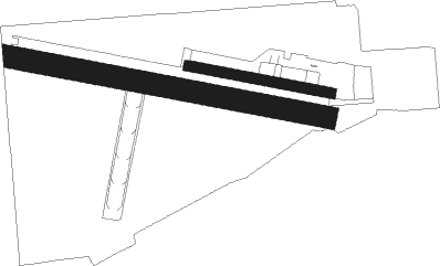
Runway info
Runway 9 / 27  | ||
| length | 1523m (4997ft) | |
| bearing | 103° / 283° | |
| width | 102m (336ft) | |
| surface | concrete | |
| Runway 8 / 26 | ||
| length | 682m (2238ft) | |
| bearing | 103° / 283° | |
| width | 46m (151ft) | |
| surface | concrete | |
Nearby beacons
| code | identifier | dist | bearing | frequency |
|---|---|---|---|---|
| NRS | IMPERIAL BEACH TACAN | 0.3 | 100° | 109.20 |
| PGY | POGGI (SAN DIEGO) VORTAC | 7.4 | 72° | 116.45 |
| TIJ | TIJUANA VOR/DME | 8.4 | 99° | 116.50 |
| NZY | NORTH ISLAND (SAN DIEGO) TACAN | 9.6 | 324° | 117 |
| MZB | MISSION BAY (SAN DIEGO) VORTAC | 14.1 | 333° | 117.80 |
| NKX | MIRAMAR (SAN DIEGO) TACAN | 18.3 | 353° | 109.60 |
| OCN | OCEANSIDE VORTAC | 43.2 | 336° | 115.30 |
| JLI | JULIAN VORTAC | 43.7 | 43° | 114 |
| NFG | CAMP PENDLETON (OCEANSIDE TACAN | 44.7 | 339° | 111.80 |
| ENS | ENSENADA NDB | 52.9 | 146° | 400 |
Disclaimer
The information on this website is not for real aviation. Use this data with the X-Plane flight simulator only! Data taken with kind consent from X-Plane 12 source code and data files. Content is subject to change without notice.