Milton - Whiting Field Nas North
Airport details
| Country | United States of America |
| State | Florida |
| Region | K7 |
| Airspace | Jacksonville Ctr |
| Municipality | Santa Rosa County |
| Elevation | 199ft (61m) |
| Timezone | GMT -6 |
| Coordinates | 30.72247, -87.02390 |
| Magnetic var | |
| Type | land |
| Available since | X-Plane v10.40 |
| ICAO code | KNSE |
| IATA code | NSE |
| FAA code | NSE |
Communication
| Whiting Field NAS North ATIS | 126.200 |
| Whiting Field NAS North Tower | 121.400 |
| Whiting Field NAS North PENSACOLA Approach | 127.350 |
| Whiting Field NAS North PENSACOLA Departure | 127.350 |
Approach frequencies
| ILS-cat-I | RW14 | 111.75 | 18.00mi |
| 3° GS | RW14 | 111.75 | 18.00mi |
Nearby Points of Interest:
Milton Historic District
-Louisville and Nashville Depot
-Mt. Pilgrim African Baptist Church
-Ollinger-Cobb House
-Arcadia Sawmill and Arcadia Cotton Mill
-Alger-Sullivan Lumber Company Residential Historic District
-Archeological Properties of the Naval Live Oaks Reservation MPS
-John Edmunds Apartment House
-Crystal Ice Company Building
-James House
-Pensacola Hospital
-Sacred Heart Catholic Church
-First Christian Church
-King-Hooton House
-Louisville and Nashville Passenger Station and Express Building
-North Hill Preservation District
-Winston E. Arnow Federal Building
-Charles William Jones House
-Pensacola Historic District
-Clara Barkley Dorr House
-Thiesen Building
-Palafox Historic District
-Lavalle House
-American National Bank Building
-United States Customs House and Post Office
Runway info
Runway 5 / 23  | ||
| length | 1831m (6007ft) | |
| bearing | 51° / 231° | |
| width | 61m (200ft) | |
| surface | asphalt | |
| Runway 14 / 32 | ||
| length | 1832m (6010ft) | |
| bearing | 133° / 313° | |
| width | 61m (200ft) | |
| surface | asphalt | |
Airport layout
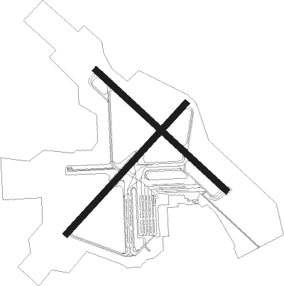
Taxiway locations
Parking locations
|
Nearby beacons
| code | identifier | dist | bearing | frequency |
|---|---|---|---|---|
| NSE | WHITING (MILTON) TACAN | 0.3 | 75° | 112.30 |
| NGS | SANTA ROSA (MILTON) TACAN | 7.8 | 141° | 133.60 |
| CEW | CRESTVIEW VORTAC | 18.8 | 73° | 115.90 |
| PKZ | PICKENS (PENSACOLA) NDB | 18.9 | 208° | 326 |
| NUN | SAUFLEY (PENSACOLA) VOR | 22 | 231° | 108.80 |
| HRT | HURLBURT (MARY ESTHER) TACAN | 24.7 | 131° | 110.80 |
| CE | KOBRA (CRESTVIEW) NDB | 26.3 | 75° | 201 |
| NPA | PENSACOLA TACAN | 26.6 | 219° | 117.20 |
| DWG | WARRINGTON (VALPARAISO) TACAN | 29.8 | 116° | 134.50 |
| MVC | MONROEVILLE VORTAC | 47.3 | 336° | 116.80 |
| JUY | JUDD (ANDALUSIA) NDB | 47.8 | 47° | 264 |
Instrument approach procedures
| runway | airway (heading) | route (dist, bearing) |
|---|---|---|
| RW14 | MERTY (134°) | MERTY 3000ft |
| RW14 | PENSI (106°) | PENSI 3000ft MERTY (7mi, 64°) 3000ft |
| RNAV | MERTY 3000ft CAGLE (5mi, 133°) 1700ft JOHNC (2mi, 133°) 1100ft KNSE (4mi, 135°) 248ft (5252mi, 109°) 700ft ANTUA (5247mi, 290°) 3000ft ANTUA (turn) 4000ft | |
| RW23 | ANTUA (214°) | ANTUA 3000ft |
| RW23 | PENSI (106°) | PENSI 3000ft ANTUA (19mi, 78°) 3000ft ANTUA (turn) 3000ft |
| RNAV | ANTUA 3000ft LINZE (6mi, 200°) 1600ft KNSE (5mi, 231°) 235ft (5252mi, 109°) 700ft TROJN (5261mi, 289°) 3000ft TROJN (turn) 4000ft |
Disclaimer
The information on this website is not for real aviation. Use this data with the X-Plane flight simulator only! Data taken with kind consent from X-Plane 12 source code and data files. Content is subject to change without notice.