Point Mugu
Airport details
| Country | United States of America |
| State | California |
| Region | K2 |
| Airspace | Los Angeles Ctr |
| Municipality | Ventura County |
| Elevation | 13ft (4m) |
| Timezone | GMT -8 |
| Coordinates | 34.11949, -119.11268 |
| Magnetic var | |
| Type | land |
| Available since | X-Plane v10.40 |
| ICAO code | KNTD |
| IATA code | NTD |
| FAA code | NTD |
Communication
| Point Mugu Point Mugu Ground | 121.600 |
| Point Mugu Point Mugu Tower | 124.850 |
| Point Mugu Point Mugu Tower (2) | 135.175 |
| Point Mugu Point Mugu Approach | 128.650 |
| Point Mugu Point Mugu Departure | 128.650 |
Approach frequencies
| ILS-cat-I | RW21 | 109.3 | 18.00mi |
| 3° GS | RW21 | 109.3 | 18.00mi |
Nearby Points of Interest:
Women's Improvement Club of Hueneme
-Berylwood
-Backbone Trail
-Saticoy Southern Pacific Railroad Depot
-George Washington Faulkner House
-First Baptist Church of Ventura
-Elizabeth Bard Memorial Hospital
-Emmanuel Franz House
-Feraud General Merchandise Store
-Ebell Club of Santa Paula
-Union Oil Company Building
-Joel McCrea Ranch
-San Buenaventura Mission Aqueduct
-Colony House (Simi, California)
-Charles M. Pratt House
-Grandma Prisbrey's Bottle Village
-Carpinteria
-Minnie Hill Palmer House
-Pico Canyon Oilfield
-Will Rogers State Historic Park
-Bradbury House
-Henry Weaver House
-Charmont Apartments
-Santa Monica Looff Hippodrome
-Rancho Los Encinos
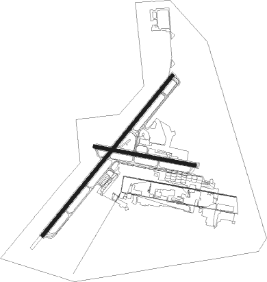
Runway info
Runway 3 / 21  | ||
| length | 3386m (11109ft) | |
| bearing | 49° / 229° | |
| width | 61m (200ft) | |
| surface | asphalt | |
| Runway 9 / 27 | ||
| length | 1676m (5499ft) | |
| bearing | 103° / 283° | |
| width | 61m (200ft) | |
| surface | asphalt | |
| blast zone | 255m (837ft) / 0m (0ft) | |
Nearby beacons
| code | identifier | dist | bearing | frequency |
|---|---|---|---|---|
| NTD | POINT MUGU (OXNARD) TACAN | 0.5 | 292° | 110.60 |
| VTU | VENTURA (OXNARD) VOR/DME | 3.1 | 94° | 108.20 |
| CMA | CAMARILLO VOR/DME | 5.6 | 11° | 115.80 |
| FIM | FILLMORE VORTAC | 18.3 | 44° | 112.50 |
| VNY | VAN NUYS VOR/DME | 31.4 | 80° | 113.10 |
| SMO | SANTA MONICA VOR/DME | 33.2 | 99° | 110.80 |
| LAX | LOS ANGELES VORTAC | 35.6 | 105° | 113.60 |
| RZS | SAN MARCUS (SANTA BARBARA VORTAC | 40.1 | 301° | 114.90 |
| GMN | GORMAN VORTAC | 42.9 | 20° | 116.10 |
| LHS | LAKE HUGHES VORTAC | 43 | 44° | 114.35 |
| GVO | GAVIOTA VORTAC | 54.4 | 293° | 113.80 |
| NSI | SAN NICOLAS (SAN NICOLAS TACAN | 55.8 | 201° | 110.20 |
| SXC | SANTA CATALINA VORTAC | 56.5 | 137° | 111.40 |
| FLW | FELLOWS VOR/DME | 69.3 | 322° | 117.50 |
Departure and arrival routes
| Transition altitude | 18000ft |
| Transition level | 18000ft |
| SID end points | distance | outbound heading | |
|---|---|---|---|
| RW03 | |||
| RZS1 | 82mi | 1° | |
| DOYLE9 | 57mi | 137° | |
| RW21 | |||
| RZS1 | 82mi | 1° | |
| DOYLE9 | 57mi | 137° | |
| RW27 | |||
| RZS1 | 82mi | 1° | |
| DOYLE9 | 57mi | 137° | |
| STAR starting points | distance | inbound heading | |
|---|---|---|---|
| RW21 | |||
| GUERA2 | 27.6 | 233° | |
Instrument approach procedures
| runway | airway (heading) | route (dist, bearing) |
|---|---|---|
| RW03 | CMA (191°) | CMA 2600ft RENET (21mi, 218°) 2600ft RENET (turn) 2600ft |
| RW03 | VTU (274°) | VTU 2700ft RENET (18mi, 235°) 2600ft RENET (turn) 2600ft |
| RNAV | RENET 2600ft CAADE (5mi, 44°) 2600ft REALL (5mi, 44°) 1500ft CEBIG (3mi, 49°) 680ft KNTD (3mi, 55°) 56ft (6832mi, 106°) 600ft RENET (6845mi, 286°) 2600ft RENET (turn) 6000ft | |
| RW21 | CMA (191°) | CMA 4000ft TROYE (9mi, 66°) 4000ft TROYE (turn) 4000ft |
| RW21 | FIM (224°) | FIM 4000ft TROYE (5mi, 214°) 4000ft |
| RNAV | TROYE 4000ft CIRET (4mi, 229°) 2900ft CIELO (2mi, 229°) 2400ft KOCKA (5mi, 229°) 880ft KNTD (3mi, 223°) 59ft (6832mi, 106°) 600ft RENET (6845mi, 286°) 2600ft RENET (turn) 6000ft |
Disclaimer
The information on this website is not for real aviation. Use this data with the X-Plane flight simulator only! Data taken with kind consent from X-Plane 12 source code and data files. Content is subject to change without notice.