Virginia Beach - Naval Air Station Oceana
Airport details
| Country | United States of America |
| State | Virginia |
| Region | K6 |
| Airspace | Washington Ctr |
| Municipality | Virginia Beach |
| Elevation | 20ft (6m) |
| Timezone | GMT -5 |
| Coordinates | 36.82547, -76.01817 |
| Magnetic var | |
| Type | land |
| Available since | X-Plane v10.40 |
| ICAO code | KNTU |
| IATA code | NTU |
| FAA code | NTU |
Communication
Nearby Points of Interest:
Oceana Neighborhood Historic District
-Upper Wolfsnare
-Camp Pendleton
-Briarwood
-Shirley Hall
-Francis Land House
-Dr. John Miller-Masury House
-Green Hill (Virginia Beach, Virginia)
-Ferry Plantation House
-Adam Keeling House
-Pembroke Manor
-Woodhouse House
-Lynnhaven House
-Adam Thoroughgood House
-The Hermitage
-Pleasant Hall
-Albemarle and Chesapeake Canal
-Weblin House
-Poplar Hall (Norfolk, Virginia)
-Thomas Murray House
-Centreville-Fentress Historic District
-Ballentine Place Historic District
-American Cigar Company
-St. Peter's Episcopal Church (Norfolk, Virginia)
-Lafayette Residence Park
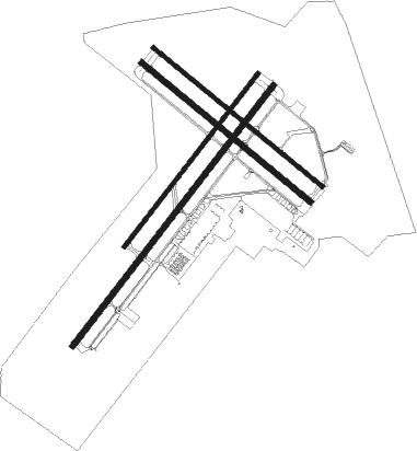
Runway info
Runway 5R / 23L  | ||
| length | 3664m (12021ft) | |
| bearing | 48° / 228° | |
| width | 61m (200ft) | |
| surface | asphalt | |
| blast zone | 40m (131ft) / 255m (837ft) | |
| Runway 5L / 23R | ||
| length | 2441m (8009ft) | |
| bearing | 48° / 228° | |
| width | 46m (150ft) | |
| surface | concrete | |
| blast zone | 46m (151ft) / 255m (837ft) | |
| Runway 14L / 32R | ||
| length | 2443m (8015ft) | |
| bearing | 128° / 308° | |
| width | 46m (150ft) | |
| surface | concrete | |
| blast zone | 11m (36ft) / 255m (837ft) | |
| Runway 14R / 32L | ||
| length | 2438m (7999ft) | |
| bearing | 128° / 308° | |
| width | 61m (200ft) | |
| surface | asphalt | |
| blast zone | 18m (59ft) / 255m (837ft) | |
Nearby beacons
| code | identifier | dist | bearing | frequency |
|---|---|---|---|---|
| NTU | OCEANA TACAN | 0.9 | 266° | 116.60 |
| NFE | CHESAPEAKE TACAN | 9.5 | 223° | 108.25 |
| ORF | NORFOLK VORTAC | 9.6 | 290° | 116.90 |
| OR | INGLE (NORFOLK) NDB | 11.2 | 274° | 329 |
| NGU | CHAMBERS (NORFOLK) TACAN | 14.2 | 294° | 113.95 |
| LFI | LANGLEY (HAMPTON) TACAN | 22.6 | 307° | 112.30 |
| CCV | CAPE CHARLES VORTAC | 31.3 | 2° | 112.20 |
| ECG | ELIZABETH CITY VOR/DME | 34.9 | 195° | 112.50 |
| LLW | WOODVILLE (ELIZABETH CITY) NDB | 36.3 | 206° | 254 |
| AKQ | WAKEFIELD NDB | 48.1 | 279° | 274 |
| FKN | FRANKLIN VORTAC | 48.2 | 264° | 110.60 |
| CVI | COFIELD VORTAC | 49.3 | 242° | 114.60 |
| HCM | HARCUM VORTAC | 50 | 312° | 108.80 |
| RBX | WRIGHT BROTHERS (MANTEO) VOR/DME | 56.5 | 160° | 111.60 |
| MQI | MANTEO NDB | 56.8 | 160° | 370 |
Departure and arrival routes
| Transition altitude | 18000ft |
| Transition level | 18000ft |
| SID end points | distance | outbound heading | |
|---|---|---|---|
| RW05 (ALL) | |||
| WYNNS3 | 145mi | 251° | |
| NTU4 | 14mi | 294° | |
| RW14 (ALL) | |||
| WYNNS3 | 145mi | 251° | |
| NTU4 | 14mi | 294° | |
| RW23 (ALL) | |||
| WYNNS3 | 145mi | 251° | |
| NTU4 | 14mi | 294° | |
| RW32 (ALL) | |||
| WYNNS3 | 145mi | 251° | |
| NTU4 | 14mi | 294° | |
| STAR starting points | distance | inbound heading | |
|---|---|---|---|
| ALL | |||
| TERKS2 | 160.9 | 109° | |
Instrument approach procedures
| runway | airway (heading) | route (dist, bearing) |
|---|---|---|
| RW05L | CVI (62°) | CVI 3000ft JUGRO (38mi, 66°) 3000ft JUGRO (turn) 3000ft |
| RNAV | JUGRO 3000ft OSUTY (6mi, 48°) 1600ft KNTU (6mi, 53°) 75ft (4735mi, 116°) 220ft HENIP (4730mi, 296°) 3000ft HENIP (turn) 6000ft | |
| RW05R | CVI (62°) | CVI 3000ft ZOKEN (38mi, 66°) 3000ft ZOKEN (turn) 3000ft |
| RNAV | ZOKEN 3000ft JAVLU (5mi, 48°) 1600ft KNTU (7mi, 51°) 73ft (4735mi, 116°) 219ft JAGNI (4730mi, 296°) 3000ft JAGNI (turn) 6000ft | |
| RW23L | CCV (182°) | CCV 3000ft JAGNI (24mi, 164°) 3000ft JAGNI (turn) 3000ft |
| RNAV | JAGNI 3000ft WAXUL (5mi, 228°) 1600ft LEVNN (3mi, 228°) 700ft KNTU (2mi, 219°) 76ft (4735mi, 116°) 221ft ZOKEN (4742mi, 296°) 3000ft ZOKEN (turn) 6000ft | |
| RW23R | CCV (182°) | CCV 3000ft HENIP (24mi, 165°) 3000ft HENIP (turn) 3000ft |
| RNAV | HENIP 3000ft COXOG (5mi, 228°) 1600ft SUTUE (3mi, 228°) 700ft KNTU (2mi, 216°) 75ft (4735mi, 116°) 221ft JUGRO (4742mi, 296°) 3000ft JUGRO (turn) 6000ft | |
| RW32L | HUGEE (310°) | HUGEE 6000ft HUGEE (turn) 3000ft |
| RNAV | HUGEE 3000ft GIBIE (5mi, 308°) 1600ft EGOBE (4mi, 308°) 236ft (4735mi, 116°) 1100ft GRAIT (4741mi, 296°) 3000ft GRAIT (turn) 6000ft | |
| RW32R | HUGEE (310°) | HUGEE 6000ft HUGEE (turn) 3000ft |
| RNAV | HUGEE 3000ft GIBIE (5mi, 308°) 1600ft EGOBE (4mi, 308°) 237ft (4735mi, 116°) 1100ft GRAIT (4741mi, 296°) 3000ft GRAIT (turn) 6000ft |
Disclaimer
The information on this website is not for real aviation. Use this data with the X-Plane flight simulator only! Data taken with kind consent from X-Plane 12 source code and data files. Content is subject to change without notice.