Mountain View - Moffett Federal Afld
Airport details
| Country | United States of America |
| State | California |
| Region | K2 |
| Airspace | Oakland Ctr |
| Municipality | Santa Clara County |
| Elevation | 33ft (10m) |
| Timezone | GMT -8 |
| Coordinates | 37.41614, -122.04914 |
| Magnetic var | |
| Type | land |
| Available since | X-Plane v10.40 |
| ICAO code | KNUQ |
| IATA code | NUQ |
| FAA code | NUQ |
Communication
| Moffett Federal AFLD MOFFETT AWOS | 122.100 |
| Moffett Federal AFLD ATIS | 124.175 |
| Moffett Federal AFLD MOFFETT CTAF | 119.550 |
| Moffett Federal AFLD MOFFETT Ground Control | 121.850 |
| Moffett Federal AFLD MOFFETT Tower | 119.550 |
| Moffett Federal AFLD MOFFETT Approach | 134.500 |
| Moffett Federal AFLD MOFFETT Departure | 121.300 |
Approach frequencies
| LOC | RW14L | 110.35 | 18.00mi |
| ILS-cat-I | RW32R | 110.35 | 18.00mi |
| 3° GS | RW32R | 110.35 | 18.00mi |
Nearby Points of Interest:
Hangar One
-Unitary Plan Wind Tunnel
-Rengstorff House
-Coyote Creek
-Greenmeadow
-Green Gables
-Paul Shoup House
-Pedro de Lemos House
-Kee House
-Agnews Developmental Center
-Pettigrew House
-Theophilus Allen House
-Norris House
-James Lick Mansion
-T. B. Downing House
-Palo Alto Medical Clinic
-Dunker House
-John Adam Squire House
-Wilson House
-Hanna–Honeycomb House
-United States Post Office (Palo Alto, California)
-Fraternal Hall Building
-Ramona Street Architectural District
-MacFarland House
-Le Petit Trianon
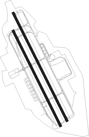
Runway info
Runway 14L / 32R  | ||
| length | 2807m (9209ft) | |
| bearing | 153° / 333° | |
| width | 61m (200ft) | |
| surface | concrete | |
| displ threshold | 0m (0ft) / 60m (197ft) | |
| blast zone | 31m (102ft) / 19m (62ft) | |
| Runway 14R / 32L | ||
| length | 2472m (8110ft) | |
| bearing | 153° / 333° | |
| width | 61m (200ft) | |
| surface | asphalt | |
| displ threshold | 0m (0ft) / 183m (600ft) | |
| blast zone | 31m (102ft) / 31m (102ft) | |
Nearby beacons
| code | identifier | dist | bearing | frequency |
|---|---|---|---|---|
| NUQ | MOFFETT (MOUNTAIN VIEW) TACAN | 1 | 333° | 117.60 |
| SJC | SAN JOSE VOR/DME | 5.5 | 112° | 114.10 |
| OSI | WOODSIDE VOR/DME | 11.1 | 264° | 113.90 |
| SFO | SAN FRANCISCO VOR/DME | 19.7 | 302° | 115.80 |
| OAK | OAKLAND VOR/DME | 20.3 | 331° | 116.80 |
| LV | REIGA (LIVERMORE) NDB | 24 | 53° | 374 |
| SAU | SAUSALITO VOR/DME | 34.6 | 313° | 116.20 |
| CCR | CONCORD VOR/DME | 37.7 | 0° | 117 |
| MR | MUNSO (MONTEREY) NDB | 48 | 172° | 385 |
| SGD | SCAGGS ISLAND (NAPA) VORTAC | 48.3 | 337° | 112.10 |
| SNS | SALINAS VORTAC | 49.9 | 149° | 117.30 |
| SUU | TRAVIS (FAIRFIELD) TACAN | 50 | 7° | 116.60 |
| PYE | POINT REYES VOR/DME | 55.6 | 309° | 113.70 |
| UAD | CHUALAR (SALINAS) NDB | 62 | 148° | 263 |
Departure and arrival routes
| Transition altitude | 18000ft |
| Transition level | 18000ft |
| SID end points | distance | outbound heading | |
|---|---|---|---|
| RW14 (ALL) | |||
| SOLN3 | 74mi | 119° | |
| HOOKS2 | 50mi | 149° | |
| OSI2 | 11mi | 264° | |
| RW32 (ALL) | |||
| SOLN3 | 74mi | 119° | |
| OSI2 | 11mi | 264° | |
| STAR starting points | distance | inbound heading | |
|---|---|---|---|
| ALL | |||
| PYE3 | 55.6 | 129° | |
Instrument approach procedures
| runway | airway (heading) | route (dist, bearing) |
|---|---|---|
| RW14L | OAK (151°) | OAK PEYIC (3mi, 139°) 3200ft EVOCU (5mi, 153°) 2600ft |
| RNAV | EVOCU 2600ft NIRYI (6mi, 153°) 1700ft KNUQ (6mi, 153°) 58ft (6902mi, 107°) 500ft PEYIC (6903mi, 287°) 3200ft PEYIC (turn) | |
| RW14R | OAK (151°) | OAK PEYIC (3mi, 139°) 3200ft EVOCU (5mi, 153°) 2600ft |
| RNAV | EVOCU 2600ft WHELP (6mi, 154°) 1700ft KNUQ (6mi, 152°) 57ft (6902mi, 107°) 540ft PEYIC (6903mi, 287°) 3200ft PEYIC (turn) | |
| RW32L | HOSNU (333°) | HOSNU 5500ft CEVGI (4mi, 333°) 5000ft |
| RNAV | CEVGI 5000ft WUMAG (4mi, 333°) 4500ft HOTLU (2mi, 333°) 3600ft FEGUM (4mi, 333°) 2500ft PUROE (5mi, 333°) 740ft JIRAP (1mi, 333°) 271ft (6902mi, 107°) 337ft PEYIC (6903mi, 287°) 3200ft PEYIC (turn) | |
| RW32R | ZAPEP (333°) | ZAPEP 5500ft AGAPE (4mi, 333°) 5200ft |
| RNAV | AGAPE 5200ft RIROC (4mi, 333°) 4400ft ORZOS (3mi, 333°) 3600ft JULUD (2mi, 333°) 3000ft EBIYI (3mi, 333°) 2100ft NUNLE (4mi, 333°) 780ft CIKGA (2mi, 333°) 237ft (6902mi, 107°) 237ft PEYIC (6903mi, 287°) 3200ft PEYIC (turn) |
Holding patterns
| STAR name | hold at | type | turn | heading* | altitude | leg | speed limit |
|---|---|---|---|---|---|---|---|
| PYE3 | PYE | NDB | right | 325 (145)° | 1.0min timed | ICAO rules | |
| PYE3 | STINS | VHF | right | 324 (144)° | 1.0min timed | ICAO rules | |
| *) magnetic outbound (inbound) holding course | |||||||
Disclaimer
The information on this website is not for real aviation. Use this data with the X-Plane flight simulator only! Data taken with kind consent from X-Plane 12 source code and data files. Content is subject to change without notice.