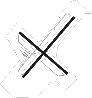
Okeechobee - Okeechobee Co
Airport details
| Country | United States of America |
| State | Florida |
| Region | K7 |
| Airspace | Miami Oceanic Ctr |
| Municipality | Okeechobee County |
| Elevation | 34ft (10m) |
| Timezone | GMT -5 |
| Coordinates | 27.26658, -80.85039 |
| Magnetic var | |
| Type | land |
| Available since | X-Plane v10.40 |
| ICAO code | KOBE |
| IATA code | OBE |
| FAA code | OBE |
Communication
| Okeechobee Co ASOS | 118.675 |
| Okeechobee Co CTAF/UNICOM | 123.000 |
Nearby Points of Interest:
Freedman-Raulerson House
-Okeechobee Battlefield
-Red Barn
-Cypress Lodge
-Immokolee
-Archbold Biological Station
-Captain Hammond House
-Old Lake Placid Atlantic Coast Line Railroad Depot
-Moore Haven Downtown Historic District
-Jules Frere House
-Moore Haven Residential Historic District
-Zora Neale Hurston House
-St. Lucie High School
-Casa Caprona
-Old St. Anastasia Catholic School
-Old Fort Pierce Post Office
-Arcade Building
-Old Fort Pierce City Hall
-Boston House
-Treasure Hammock Ranch Farmstead
-Executive House
-St. Lucie Village Historic District
-Capt. F. Deane Duff House
-Scharnberg House
-Clewiston Theater

Nearby beacons
| code | identifier | dist | bearing | frequency |
|---|---|---|---|---|
| FPR | FORT PIERCE NDB | 28.6 | 65° | 275 |
| PHK | PAHOKEE VOR/DME | 30.2 | 162° | 115.40 |
| TRV | TREASURE (VERO BEACH) VORTAC | 31.3 | 41° | 117.30 |
| UTX | UNITED NDB | 34.9 | 125° | 405 |
| LBV | LA BELLE VORTAC | 39.1 | 231° | 110.40 |
| MLB | MELBOURNE VOR/DME | 51.6 | 14° | 115.85 |
| PBI | PALM BEACH VORTAC | 53.9 | 128° | 115.70 |
| COF | PATRICK (COCOA) TACAN | 59.6 | 14° | 115 |
| RSW | LEE COUNTY (FORT MYERS) VORTAC | 66.4 | 231° | 111.80 |
Instrument approach procedures
| runway | airway (heading) | route (dist, bearing) |
|---|---|---|
| RW05 | LLNCH (222°) | LLNCH FINLO (24mi, 225°) 2000ft FINLO (turn) 2000ft |
| RW05 | SIGNL (50°) | SIGNL FINLO (9mi, 51°) 2000ft |
| RNAV | FINLO 2000ft CORDI (6mi, 48°) 1500ft KOBE (5mi, 48°) 73ft (4917mi, 109°) 283ft JABIT (4910mi, 289°) 2000ft JABIT (turn) | |
| RW14 | TRV (221°) | TRV JOKOB (29mi, 241°) 2000ft |
| RNAV | JOKOB 2000ft ZEBMO (6mi, 163°) 1600ft OTAGE (3mi, 132°) 580ft KOBE (2mi, 130°) 73ft (4917mi, 109°) 340ft LIYZU (4909mi, 289°) 2000ft LIYZU (turn) | |
| RW23 | SIGNL (50°) | SIGNL JABIT (32mi, 49°) 2000ft JABIT (turn) 2000ft |
| RW23 | SMUGS (278°) | SMUGS JABIT (25mi, 297°) 2000ft |
| RW23 | TRV (221°) | TRV JABIT (20mi, 217°) 2000ft |
| RNAV | JABIT 2000ft NEPOE (6mi, 228°) 1600ft HEGIP (3mi, 228°) 600ft KOBE (2mi, 228°) 91ft (4917mi, 109°) 315ft FINLO (4924mi, 289°) 2000ft FINLO (turn) | |
| RW32 | PHK (342°) | PHK LIYZU (21mi, 358°) 2000ft |
| RW32 | SHEDS (262°) | SHEDS LIYZU (12mi, 215°) 2000ft LIYZU (turn) 2000ft |
| RNAV | LIYZU 2000ft ODNAE (6mi, 312°) 1600ft MUVPY (3mi, 312°) 700ft KOBE (2mi, 313°) 72ft (4917mi, 109°) 283ft KEVBE (4920mi, 289°) IDLUW (6mi, 48°) JABIT (7mi, 82°) 2000ft JABIT (turn) |
Disclaimer
The information on this website is not for real aviation. Use this data with the X-Plane flight simulator only! Data taken with kind consent from X-Plane 12 source code and data files. Content is subject to change without notice.