Odessa - Odessa-schlemeyer Field
Airport details
| Country | United States of America |
| State | Texas |
| Region | K4 |
| Airspace | Ft Worth Ctr |
| Municipality | Ector County |
| Elevation | 3002ft (915m) |
| Timezone | GMT -6 |
| Coordinates | 31.92141, -102.38713 |
| Magnetic var | |
| Type | land |
| Available since | X-Plane v10.40 |
| ICAO code | KODO |
| IATA code | n/a |
| FAA code | ODO |
Communication
| Odessa-Schlemeyer Field ASOS | 119.275 |
| Odessa-Schlemeyer Field CTAF/UNICOM | 123.000 |
| Odessa-Schlemeyer Field MIDLAND Approach/Departure | 124.600 |
Runway info
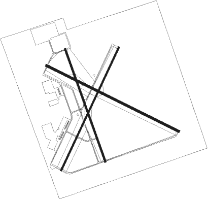
Runway 2 / 20  | ||
| length | 1740m (5709ft) | |
| bearing | 34° / 214° | |
| width | 23m (75ft) | |
| surface | asphalt | |
| Runway 16 / 34 | ||
| length | 1526m (5007ft) | |
| bearing | 162° / 342° | |
| width | 23m (75ft) | |
| surface | asphalt | |
| Runway 11 / 29 | ||
| length | 1892m (6207ft) | |
| bearing | 117° / 297° | |
| width | 30m (100ft) | |
| surface | asphalt | |
Nearby beacons
| code | identifier | dist | bearing | frequency |
|---|---|---|---|---|
| MA | FARLY (MIDLAND) NDB | 5.1 | 43° | 326 |
| MAF | MIDLAND VORTAC | 11.3 | 66° | 114.80 |
| INK | WINK VORTAC | 43.7 | 267° | 112.10 |
| BGS | BIG SPRING VORTAC | 53.7 | 63° | 117.20 |
| HOB | HOBBS VORTAC | 62.1 | 309° | 111 |
| FST | FORT STOCKTON VORTAC | 65.5 | 211° | 116.90 |
Instrument approach procedures
| runway | airway (heading) | route (dist, bearing) |
|---|---|---|
| RW11 | GOMIT (123°) | GOMIT KIMTE (6mi, 135°) 5000ft |
| RW11 | PIZON (163°) | PIZON KIMTE (11mi, 220°) 5000ft |
| RW11 | YOGSU (97°) | YOGSU KIMTE (5mi, 40°) 5000ft |
| RNAV | KIMTE 5000ft ISOBY (6mi, 117°) 4700ft JIVDU (3mi, 117°) 3640ft KODO (2mi, 119°) 3014ft (6035mi, 107°) 3174ft JEMBI (6026mi, 287°) 5000ft JEMBI (turn) | |
| RW20 | MERGE (214°) | MERGE NOING (13mi, 213°) 5100ft |
| RW20 | PIZON (163°) | PIZON NOING (11mi, 113°) 5100ft |
| RNAV | NOING 5100ft FERTH (6mi, 214°) 4700ft KODO (6mi, 213°) 3042ft (6035mi, 107°) 3410ft PIZON (6037mi, 287°) 5100ft PIZON (turn) | |
| RW29 | JOKES (274°) | JOKES JEMBI (18mi, 259°) 5000ft |
| RW29 | OHARA (14°) | OHARA WAGVO (12mi, 68°) 5000ft JEMBI (5mi, 35°) 5000ft |
| RNAV | JEMBI 5000ft FODGA (6mi, 297°) 4700ft HUDUP (3mi, 297°) 3660ft KODO (3mi, 295°) 3020ft KIMTE (12mi, 297°) 5000ft KIMTE (turn) |
Disclaimer
The information on this website is not for real aviation. Use this data with the X-Plane flight simulator only! Data taken with kind consent from X-Plane 12 source code and data files. Content is subject to change without notice.