Olean - Cattaraugus Co Olean
Airport details
| Country | United States of America |
| State | New York |
| Region | K6 |
| Airspace | Cleveland Ctr |
| Municipality | Cattaraugus County |
| Elevation | 2132ft (650m) |
| Timezone | GMT -5 |
| Coordinates | 42.24122, -78.37136 |
| Magnetic var | |
| Type | land |
| Available since | X-Plane v10.40 |
| ICAO code | KOLE |
| IATA code | n/a |
| FAA code | OLE |
Communication
| Cattaraugus Co Olean CTAF/UNICOM | 122.800 |
Approach frequencies
| LOC | RW22 | 109.3 | 18.00mi |
Nearby Points of Interest:
Main Street Historic District
-South Street Historic District
-McKinney Stables of Empire City Farms
-Randolph Historic District
-North Lyndon Schoolhouse
-Park Square Historic District
-Simeon B. Robbins House
-Pfeiffer-Wheeler American Chestnut Cabin
-Beardsley-Oliver House
-Olean Armory
-Conklin Mountain House
-Union and State Streets Historic District
-United States Post Office
-Olean School No. 10
-Friendship Free Library
-Bryant Hill Cemetery
-William E. Wheeler House
-Portville Free Library
-Rail and Titsworth Canal Warehouse
-Jefferson Street Cemetery
-Ellicottville Historic District
-House at 520 Hostageh Road
-Belmont Grange No. 1243
-Belmont Literary and Historical Society Free Library
-Belvidere
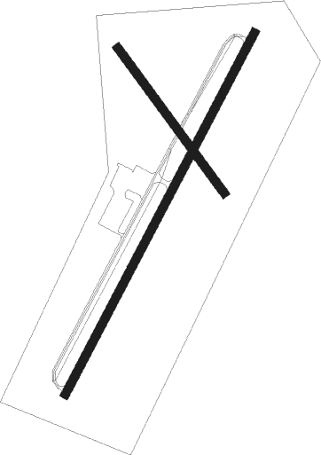
Runway info
Runway 4 / 22  | ||
| length | 1465m (4806ft) | |
| bearing | 40° / 220° | |
| width | 30m (100ft) | |
| surface | asphalt | |
| displ threshold | 30m (98ft) / 61m (200ft) | |
| Runway 16 / 34 | ||
| length | 645m (2116ft) | |
| bearing | 140° / 320° | |
| width | 30m (100ft) | |
| surface | grass | |
Nearby beacons
| code | identifier | dist | bearing | frequency |
|---|---|---|---|---|
| ELZ | DME | 18.8 | 112° | 111.40 |
| BFD | DME | 29.4 | 209° | 116.60 |
| JHW | JAMESTOWN VOR/DME | 33.5 | 266° | 114.70 |
| DKK | DME | 42.7 | 285° | 116.20 |
| GB | PLAZZ (BUFFALO) NDB | 42.7 | 325° | 204 |
| BUF | BUFFALO VOR/DME | 43 | 338° | 116.40 |
| GEE | GENESEO VOR/DME | 45.4 | 47° | 108.20 |
| BU | KLUMP (BUFFALO) NDB | 47.2 | 340° | 231 |
| SLT | SLATE RUN VORTAC | 47.2 | 151° | 113.90 |
| SFK | STONYFORK VOR/DME | 53.6 | 120° | 108.60 |
| IA | KATHI (NIAGRA FALLS) NDB | 56 | 332° | 329 |
| IAG | NIAGARA FALLS TACAN | 58.4 | 326° | 111 |
| ROC | ROCHESTER VOR/DME | 61 | 39° | 110 |
| SN | ST CATHARINES NDB | 66.9 | 316° | 408 |
Instrument approach procedures
| runway | airway (heading) | route (dist, bearing) |
|---|---|---|
| RW04 | VAKTY (40°) | VAKTY 6000ft VAKTY (turn) 4900ft |
| RNAV | VAKTY 4900ft WOCDO (8mi, 40°) 3300ft KOLE (4mi, 40°) 2172ft (4890mi, 118°) 2382ft UGASE (4885mi, 298°) 4500ft UGASE (turn) | |
| RW22 | UGASE (220°) | UGASE 6000ft UGASE (turn) 4500ft |
| RNAV | UGASE 4500ft UHZOS (8mi, 220°) 3200ft KOLE (4mi, 221°) 2154ft (4890mi, 118°) 2382ft VAKTY (4895mi, 298°) 4900ft VAKTY (turn) |
Disclaimer
The information on this website is not for real aviation. Use this data with the X-Plane flight simulator only! Data taken with kind consent from X-Plane 12 source code and data files. Content is subject to change without notice.